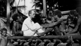
This is a short collection, which features the work of students in Dr. …
This is a short collection, which features the work of students in Dr. Mark Kinney's course, ICST 471, ANTH 470, SOCI 493: Enculturation and Spiritual Development Across Cultures, taught at Evangel University, 2022-2023. The course has used the open textbook Discovering Cultural Anthropology by Antonia M. Santangelo.
With increasing public awareness of the multiple effects of global environmental change, …
With increasing public awareness of the multiple effects of global environmental change, the terms water, energy, and food crisis have become widely used in scientific and political debates on sustainable development and environmental policy. Although each of these crises has distinct drivers and consequences, providing sustainable supplies of water, energy, and food are deeply interrelated challenges and require a profound understanding of the political, socioeconomic, and cultural factors that have historically shaped these interrelations at a local and global scale.
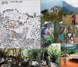
This module provides descriptive notes and images that can support teaching and …
This module provides descriptive notes and images that can support teaching and learning about ethnobotany and landscape ethnoecology, or the integrative study of human-resource relationships. The photos and graphics are mostly derived from field study and research at Mt. Kasigau, Kenya (1999-2015) as a case example. I openly make them available through the OER site for educational purposes. The resources attached to the module include:I. Ethnobotany- descriptive notes and images (ethnobotany_notes_oer) and a powerpoint presentation (ethno_div_oer);II. Landscape Ethnoecology- descriptive notes and images (landscape_ethnoecology_oer) and a powerpoint presentation (landscape_ethno_oer);III. Participatory Inquiry in Ethnobotany and Landscape Ethnoecology- descriptive notes and images (ethno_participatory_oer) and a powerpoint presentation (ethno_process_outcome_oer);IV. Collaborative Field Guide to Woody Plants and their Uses at Mt. Kasigau, Kenya (kasigauplantbook_may2013.pdf)
n 2021, the United States saw the addition of 851 new electric …
n 2021, the United States saw the addition of 851 new electric generating and storage units with at least 1 MW capacity, totaling 37,769 MW of new capacity. Wind and solar accounted for 79% of this new capacity, followed by natural gas (11%) and storage (9%).
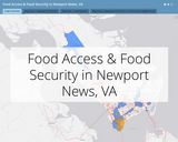
The series of maps presented here accompany a mixed-method, collaborative, and community-based …
The series of maps presented here accompany a mixed-method, collaborative, and community-based research project conducted as a part of a field research course in the Department of Sociology, Social Work, and Anthropology at Christopher Newport University.
The project focused on food access and its implications for food security and food justice in Newport News’ Southeast Community, a neighborhood marked by high levels of food insecurity and decades of racial segregation and economic divestment. The U.S. Department of Agriculture defines the Southeast Community of Newport News as a food desert, meaning that census tracts in this part of the city have higher than normal rates of poverty and include many areas that are more than 1-km walking distance from a grocery store or other source of competitively priced, nutritious food.
The discipline of Geography focuses on the science of place and space; …
The discipline of Geography focuses on the science of place and space; on how humans and the environment interact and influence each other. Our world is not flat and even though the problems we face seem global, each place on earth is experiencing them unevenly because of its location, resources, culture, and history. This course will help students to understand how most of the contemporary global challenges date back to colonialism and how complex our problems are and display spatial variability. Several global issues, such as migration, security, food, health, energy, and climate are the major topics to study the increasing global interconnectedness and socio ecological impacts of political, economic, and cultural globalization.
In this course students will: Demonstrate an ability to think globally and use geographic perspectives to analyze global phenomena. Critique various economic and political systems with regards to government influence in trade, development , environmental impacts, and social welfare. Evaluate their own lives and their connection to other cultures, places, and peoples in the world.
Latin America covers part of North America, South America and the West …
Latin America covers part of North America, South America and the West Indies. It stretches from Atacama desert to rugged highlands and Alpine glaciers of the Andes mountains, from the Rio Grande to Tierra del Fuego.The fertile plains of the Pampas is one of the world's richest agricultural regions. The Amazon Basin is the largest and wettest lowland in the world. Culturally, Latin America is a great mixture of European, indigenous and African cultures.
In this course, we will examine the peoples and places of Latin America from a geographical perspective. We will explore the geographical dimensions of economic, cultural, political, and physical forces influencing Latin America as a region. We will have a mixture of thematic and regional approaches to study the concepts and look into various physical and historical processes that have shaped dynamic and diverse cultural landscapes. We will study contemporary environmental and developmental issues, trends in migration, agricultural change, and globalization to understand Latin America's position in the global economy.
Learning Outcomes: *Analyze and articulate geographic concepts related to the geography of Latin America, its physical environment, peoples, cultures, and history. *Analyze changing political and economic relationships between the United States and countries in Latin America in order to be a more informed and engaged global citizen. *Interpret maps, graphs, and visuals as tools for analyzing the distribution patterns of phenomena and understanding their importance. *Evaluate how changing cultural, social, political, and economic characteristics of Latin American countries influence internal strife and external intervention. *Understand the complexities that contribute to the social inequality, political conflict, and environmental concerns prevalent in some Latin American countries and discuss possible solutions.
The goal of these class activities is to help students interpret maps …
The goal of these class activities is to help students interpret maps and associated data. The first activity highlights underinvestment in disadvantaged communities across the United States. The second activity explores women’s rights and inequality from a global perspective.
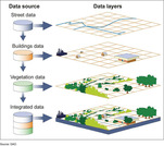
A geographic information system (GIS) is a computer system for capturing, storing, …
A geographic information system (GIS) is a computer system for capturing, storing, checking, and displaying data related to positions on Earth’s surface.
After decades of efforts to promote development, why is there so much …
After decades of efforts to promote development, why is there so much poverty in the world? What are some of the root causes of inequality world-wide and why do poverty, economic transformations and development policies often have different consequences for women and men? This course explores these issues while also examining the history of development itself, its underlying assumptions, and its range of supporters and critics. It considers the various meanings given to development by women and men, primarily as residents of particular regions, but also as aid workers, policy makers and government officials. In considering how development projects and policies are experienced in daily life in urban and rural areas in Africa, Latin America, Asia and Melanesia, this course asks what are the underlying political, economic, social, and gender dynamics that make "development" an ongoing problem world-wide.
This Lesson Plan was created by Joanna Pruitt as part of the …
This Lesson Plan was created by Joanna Pruitt as part of the 2020 ESU-NDE Remote Learning Plan Project. This original lesson is for classroom use; however, there is a virtual option as well. Educators worked with coaches to create Remote Learning Plans as a result of the COVID-19 pandemic. The attached Lesson Plan is designed for Grades 9-12 English Language Arts students; however, this could also be used as a Social Studies project as well. Students will evaluate credible sources through research on genocides post World War II after completing a novel unit covering the Holocaust. Students will also create scrapbooks using summarizing, citation, informative writing, textual evidence, caption writing, and persuasive writing. Students will also be expected to demonstrate oral communication skills as they have to present their projects to the class. Students will use background knowledge to clarify text and also gain a deeper understanding by using relevant evidence from a variety of sources to assist in analysis and reflection of informative text.
A good detective or researcher like Sherlock Holmes knows the fundamental questions …
A good detective or researcher like Sherlock Holmes knows the fundamental questions that need to be answered to gather facts to solve a problem. So how does geospatial intelligence contribute to answering these questions? While geospatial technology is useful in revealing who, what, when, and where events take place, it is less useful in explaining why events occur. However, geospatial intelligence analysis leverages geographic information science and technology with the intelligence tradecraft to develop products that support decision-making in national and homeland security, law enforcement, emergency management, and international relief efforts. GEOG 882 will challenge you to think critically, consider alternative viewpoints, and question your own assumptions when analyzing why human events occur over place and time.
Word Count: 55656 (Note: This resource's metadata has been created automatically by …
Word Count: 55656
(Note: This resource's metadata has been created automatically by reformatting and/or combining the information that the author initially provided as part of a bulk import process.)
What factors lead to a natural disaster? What causes a famine? Why …
What factors lead to a natural disaster? What causes a famine? Why do cities flood? According to a recent article in The Atlantic, Houston's flooding during the 2017 Hurricane Harvey was primarily caused by impervious pavement which prevents the absorption of water into the land. This example illustrates how nature and society are interlinked, which is the main focus of Geography 30, Penn State's introductory course to nature-society geography. In addition to examining the linkages between human development and natural hazards, this course will also explore human society's connection to food systems, climate change, urbanization and biodiversity. The course will also cover topics of ethics and decision making in order to help students evaluate the tradeoffs of these interconnections. \The Atlantic\" needs to be made into a link pointing to this: https://www.theatlantic.com/technology/archive/2017/08/why-cities-flood/538251/"
Latin America covers part of North America, South America, and the West …
Latin America covers part of North America, South America, and the West Indies. It stretches from lifeless Atacama desert to rugged highlands and Alpine glaciers of the Andes mountains. The fertile plains of the Pampas are one of the world's richest agricultural regions. The Amazon Basin is the largest and wettest lowland in the world. Culturally, Latin America is a great mixture of European, indigenous and African cultures.
In this course, we will examine the peoples and places of Latin America from a geographical perspective. We will explore the geographical dimensions of economic, cultural, political, and physical forces influencing Latin America as a region. We will have a mixture of thematic and regional approaches to study the concepts and look into various physical and historical processes that have shaped dynamic and diverse cultural landscapes. We will study contemporary environmental and developmental issues, trends in migration, agricultural change, and globalization to understand Latin America's position in the global economy.
COURSE LEVEL LEARNING OUTCOMES
Define Latin America as a world region. Identify the main physical and cultural features and characteristics of Latin America. Interpret maps, graphs, and visuals as tools for analyzing the distribution patterns of phenomena and understanding their importance in the context of Latin America. Explain the impacts of European colonialism in Latin America. Evaluate how changing cultural, social, political, and economic characteristics of Latin American countries influence internal strife and external intervention. Explain the complexities that contributed to the social inequality, political conflict, and environmental concerns prevalent in some Latin American countries. Discuss the changing political and economic relationships between the United States and countries in Latin America.
This lesson plan was created by Jennifer Pritchett as part of the …
This lesson plan was created by Jennifer Pritchett as part of the 2020 Nebraska CTE-Beginning Teachers Institute. The attached lesson plan is designed for students in grades 7-12 as a introduction to a service learning project. This lesson plan can also be used in classes such as Sociology, Introduction to Education, Ethics, Leadership, etc. Students will learn the meanings of values and rank their top 5 values in a hands on or virtual format. The culminating project is collaboration on a Google Slides presentation with the rest of the class.
The Council on Foreign Relations (CFR) and National Geographic commissioned a survey …
The Council on Foreign Relations (CFR) and National Geographic commissioned a survey to gauge what young people educated in American colleges and universities know about geography, the environment, demographics, U.S. foreign policy, recent international events, and economics. The survey, conducted in May 2016 among 1,203 respondents aged eighteen to twenty-six, revealed significant gaps between what young people understand about today’s world and what they need to know to successfully navigate and compete in it. Included on site is the full survey report (PDF) and a sample quiz of some of the survey questions.
This subject examines the paradoxes of contemporary globalization. Through lectures, discussions and …
This subject examines the paradoxes of contemporary globalization. Through lectures, discussions and student presentations, we will study the cultural, linguistic, social and political impact of globalization across broad international borders. We will pay attention to the subtle interplay of history, geography, language and cultural norms that gave rise to specific ways of life. The materials for the course include fiction, nonfiction, audio pieces, maps and visual materials.
This course explores the values (aesthetic, moral, cultural, religious, prudential, political) expressed …
This course explores the values (aesthetic, moral, cultural, religious, prudential, political) expressed in the choices of food people eat. Analyzes the decisions individuals make about what to eat, how society should manage food production and consumption collectively, and how reflection on food choices might help resolve conflicts between different values.
Renew Boston Trust is a program launched by the City of Boston …
Renew Boston Trust is a program launched by the City of Boston to improve energy efficiency in municipal buildings. By implementing energy conservation measures, such as lighting upgrades and weatherization, the program aims to reduce energy use and lower greenhouse gas emissions
No restrictions on your remixing, redistributing, or making derivative works. Give credit to the author, as required.
Your remixing, redistributing, or making derivatives works comes with some restrictions, including how it is shared.
Your redistributing comes with some restrictions. Do not remix or make derivative works.
Most restrictive license type. Prohibits most uses, sharing, and any changes.
Copyrighted materials, available under Fair Use and the TEACH Act for US-based educators, or other custom arrangements. Go to the resource provider to see their individual restrictions.