This presentation offers an overview of the developing concept of The Anthropocene …
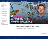
This presentation offers an overview of the developing concept of The Anthropocene -- a term coined to describe our current geological epoch, in which human impact on the planet will leave a permanent trace.
In which John Green, Hank Green, and Emily Graslie teach you about …
In which John Green, Hank Green, and Emily Graslie teach you about the Anthropocene, an unofficial geological era that covers the last century or so, in which humanity has made massive progress. We've discovered the Higgs-Boson particle, and awesome electric cars, and amazing smartphones. So all this collective learning and progress has been good for everyone, right? Maybe not. We'll look at some of the pros and cons of all this "progress," including environmental impact, changes in the way people live and work, and political changes and wars that come along with the modern world. We've come a long way, but there's a long way to go. Crash Course will also take a look at what's going to happen in the near future. If we manage to make our way through the coming bottlenecks, we could be OK in coming centuries. Don't get too hopeful, though. The Sun will eventually die, and the Earth will be destroyed, and later the universe will eventually experience heat death.
This course focuses on the practical applications of the continuum concept for …
This course focuses on the practical applications of the continuum concept for deformation of solids and fluids, emphasizing force balance. Topics include stress tensor, infinitesimal and finite strain, and rotation tensors. Constitutive relations applicable to geological materials, including elastic, viscous, brittle, and plastic deformation are studied.
This lab exercise provides students with activities utilizing vector operations within the …
This lab exercise provides students with activities utilizing vector operations within the context of the atmospheric and oceanic environments.
(Note: this resource was added to OER Commons as part of a batch upload of over 2,200 records. If you notice an issue with the quality of the metadata, please let us know by using the 'report' button and we will flag it for consideration.)
In this jigsaw-method activity on subduction zone volcanism, students apply lessons learned …
In this jigsaw-method activity on subduction zone volcanism, students apply lessons learned from four historic eruptions to the volcanic hazards associated with Mt. Rainier in the Pacific Northwest.
(Note: this resource was added to OER Commons as part of a batch upload of over 2,200 records. If you notice an issue with the quality of the metadata, please let us know by using the 'report' button and we will flag it for consideration.)
This short video from NASA discusses the role that salinity plays in …
This short video from NASA discusses the role that salinity plays in Earth's climate and ocean circulation, focusing on the observations of the Aquarius satellite.
Students describe the hydrogeologic properties of different sedimentary and volcanic rocks. (Note: …
Students describe the hydrogeologic properties of different sedimentary and volcanic rocks.
(Note: this resource was added to OER Commons as part of a batch upload of over 2,200 records. If you notice an issue with the quality of the metadata, please let us know by using the 'report' button and we will flag it for consideration.)
This activity is best placed as a follow-up activity to the study …
This activity is best placed as a follow-up activity to the study of minerals and the three major rock types in an introductory physical geology course. Students are required to work in small cooperative groups. Each group chooses a major building to research. The group divides the tasks associated with the research and presentation of information. The overall goal of the project is for students to gain an understanding of the importance and uses of earth materials in building and planning major buildings in an urban setting.
The general format of the project is: 1. Students research building design, placement and use of earth materials in a major building. 2. Students research the earth materials used in their building. 3. Students create and show their PowerPoint presentation in class. 4. Students prepare and deliver an on-site oral presentation about their building.
The activity helps students connect a basic study of earth materials to urban planning and living.
(Note: this resource was added to OER Commons as part of a batch upload of over 2,200 records. If you notice an issue with the quality of the metadata, please let us know by using the 'report' button and we will flag it for consideration.)
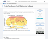
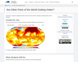
In this middle school and high school unit, students engage with 360° …
In this middle school and high school unit, students engage with 360° virtual reality tours, authentic Arctic datasets, and app-based labs to construct models and explanations for the unit driving question, "Why might the Arctic be warming twice as fast as the rest of the world?"
Students will complete this survey that determines their personal and household contributions …
Students will complete this survey that determines their personal and household contributions to atmospheric Carbon dioxide by using information about their previous year's consumption. They will understand that Carbon dioxide is a greenhouse gas produced by the combustion of fossil fuels, and that its production can be minimized by taking personal steps to conserve.
In this problem-based learning module, students will ‘dig’ for fossils in a digital …
In this problem-based learning module, students will ‘dig’ for fossils in a digital environment, using the advanced graphing techniques of line-of-best-fit and piecewise functions to look for different kinds of trends in the health of the history of the earth. They will apply this information to their knowledge of the laws of superposition and index fossils to form a complete analysis in the historical health as well as to predict where we are going in the future.
In this laboratory exercise students will have an opportunity to examine the …
In this laboratory exercise students will have an opportunity to examine the crystal structures, optical properties and health hazards of the common asbestos minerals. The laboratory will reinforce optical microscopic skills that students have learned in mineralogy and show them how mineralogy can be critical to understanding a current public policy issue.
(Note: this resource was added to OER Commons as part of a batch upload of over 2,200 records. If you notice an issue with the quality of the metadata, please let us know by using the 'report' button and we will flag it for consideration.)
Assemble a regional geologic history by compiling observations made a several sites. …
Assemble a regional geologic history by compiling observations made a several sites.
(Note: this resource was added to OER Commons as part of a batch upload of over 2,200 records. If you notice an issue with the quality of the metadata, please let us know by using the 'report' button and we will flag it for consideration.)
Instruction on use of Fisher statistics to determine the mean and 95% …
Instruction on use of Fisher statistics to determine the mean and 95% confidence interval of geological vectors, lines or planes, with examples, problems and an Excel spreadsheet for computation.
(Note: this resource was added to OER Commons as part of a batch upload of over 2,200 records. If you notice an issue with the quality of the metadata, please let us know by using the 'report' button and we will flag it for consideration.)
This project helps familiarize students with data commonly available from well drillers, …
This project helps familiarize students with data commonly available from well drillers, the Department of Natural Resources and Conservation, and the Montana Bureau of Mines and Geology. Such data is often used to produce consulting reports. In this exercise, students practice working with available data and writing a consulting report while working on a real project of local interest. The question involves the probability of success in drilling a large well for a new county park. Students are given various maps and are guided through the use of a statewide database that contains well logs and well data. The outcome is a written report that describes the location and general geology of the site, uses the available data to summarize the types of materials that a driller might encounter, answers the questions that the client is interested in, and identifies problems or advantages presented by the groundwater system as indicated by available data.
(Note: this resource was added to OER Commons as part of a batch upload of over 2,200 records. If you notice an issue with the quality of the metadata, please let us know by using the 'report' button and we will flag it for consideration.)
Through this earth science curricular unit, student teams are presented with the …
Through this earth science curricular unit, student teams are presented with the scenario that an asteroid will impact the Earth. In response, their challenge is to design the location and size of underground caverns to shelter the people from an uninhabitable Earth for one year. Driven by this adventure scenario, student teams 1) explore general and geological maps of their fictional state called Alabraska, 2) determine the area of their classroom to help determine the necessary cavern size, 3) learn about map scales, 4) test rocks, 5) identify important and not-so-important rock properties for underground caverns, and 6) choose a final location and size.
This course covers the fundamentals of astrodynamics, focusing on the two-body orbital …
This course covers the fundamentals of astrodynamics, focusing on the two-body orbital initial-value and boundary-value problems with applications to space vehicle navigation and guidance for lunar and planetary missions, including both powered flight and midcourse maneuvers. Other topics include celestial mechanics, Kepler's problem, Lambert's problem, orbit determination, multi-body methods, mission planning, and recursive algorithms for space navigation. Selected applications from the Apollo, Space Shuttle, and Mars exploration programs are also discussed.
LiDAR-Derived Digital Outcrops, 3D Hand Samples, Petrography, and Geochemistry Short Description: Classic …
LiDAR-Derived Digital Outcrops, 3D Hand Samples, Petrography, and Geochemistry
Short Description: Classic Central Gneiss Belt of the Grenville outcrops are revealed in this image-dense geological reference book. Each site is complete with 3D models of outcrops, rock samples, and virtual thin sections. Geochemical data is also available for some samples. High resolution images of thin sections and more detailed descriptions are available to post-secondary instructors upon request.
Word Count: 7112
(Note: This resource's metadata has been created automatically by reformatting and/or combining the information that the author initially provided as part of a bulk import process.)
LiDAR-Derived Digital Outcrops, 3D Hand Samples, Petrography, and Geochemistry Short Description: Classic …
LiDAR-Derived Digital Outcrops, 3D Hand Samples, Petrography, and Geochemistry
Short Description: Classic Central Metasedimentary Belt of the Grenville outcrops are revealed in this image-dense geological reference book. Each site is complete with 3D models of outcrops, rock samples, and virtual thin sections. Geochemical data is also available for some samples. High resolution images of thin sections and more detailed descriptions are available to post-secondary instructors upon request.
Word Count: 5365
(Note: This resource's metadata has been created automatically by reformatting and/or combining the information that the author initially provided as part of a bulk import process.)
No restrictions on your remixing, redistributing, or making derivative works. Give credit to the author, as required.
Your remixing, redistributing, or making derivatives works comes with some restrictions, including how it is shared.
Your redistributing comes with some restrictions. Do not remix or make derivative works.
Most restrictive license type. Prohibits most uses, sharing, and any changes.
Copyrighted materials, available under Fair Use and the TEACH Act for US-based educators, or other custom arrangements. Go to the resource provider to see their individual restrictions.