This is not a typical e-book; it is a free, web-based, open-source …
This is not a typical e-book; it is a free, web-based, open-source “textbook” available to anyone interested in using mapping tools to create maps. This e-text focuses primarily on Geographic Information Systems (GIS)—a geospatial technology that enables you to create spatial databases, analyze spatial patterns, and produce maps that communicate more effectively. While this GIS textbook is principally an introduction to GIS, most of the chapter’s concepts are applicable to other geotechnologies including remote sensing, global positioning systems (GPS), Internet mapping, and virtual globes.
Creating good maps and analyzing spatial data is a time consuming and challenging practice, but recently, a new set of powerful mapping tools has enabled almost anyone with a computer to make maps easily and to perform at least some low-level analyses. The results, however, are not encouraging. Most of the new mapmakers do not have adequate training in mapping concepts and spatial analysis principles, and their maps are often improperly designed and do not communicate easily nor effectively. This e-text—GIS Commons—seeks to help you analyze spatial data and communicate more effectively. In short, GIS education is our goal.
A geographic information system (GIS) is a computer system for capturing, storing, …
A geographic information system (GIS) is a computer system for capturing, storing, checking, and displaying data related to positions on Earth’s surface.
This resource was created as part of a project to develop open-access …
This resource was created as part of a project to develop open-access lab notes for the University of Ottawa's "GIS and the Digital Earth" course and its French counterpart "SIG et la Terre numérique". It contains lab notes for five labs with exercises for this introductory course, as well as the data needed for students to work through the labs. All labs are based on ArcGIS Pro, and requires students to have access to this software.
This is a freshman advising seminar. The professor of a FAS is …
This is a freshman advising seminar. The professor of a FAS is the first year advisor to the (no more than 8) students in the seminar. The use of Global Positioning System (GPS) in a wide variety of applications has exploded in the last few years. In this seminar we explore how positions on the Earth were determined before GPS; how GPS itself works and the range of applications in which GPS is now a critical element. This seminar is followed by a UROP research project in the spring semester where results from precise GPS measurements will be analyzed and displayed on the Web.
A good detective or researcher like Sherlock Holmes knows the fundamental questions …
A good detective or researcher like Sherlock Holmes knows the fundamental questions that need to be answered to gather facts to solve a problem. So how does geospatial intelligence contribute to answering these questions? While geospatial technology is useful in revealing who, what, when, and where events take place, it is less useful in explaining why events occur. However, geospatial intelligence analysis leverages geographic information science and technology with the intelligence tradecraft to develop products that support decision-making in national and homeland security, law enforcement, emergency management, and international relief efforts. GEOG 882 will challenge you to think critically, consider alternative viewpoints, and question your own assumptions when analyzing why human events occur over place and time.
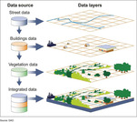
In this data rich world, we need to understand how things are …
In this data rich world, we need to understand how things are organized on the Earth's surface. Those things are represented by spatial data and necessarily depend upon what surrounds them. Spatial statistics provide insights into explaining processes that create patterns in spatial data. In geographical information analysis, spatial statistics such as point pattern analysis, spatial autocorrelation, and spatial interpolation will analyze the spatial patterns, spatial processes, and spatial association that characterize spatial data. Understanding spatial analysis will help you realize what makes spatial data special and why spatial analysis reveals a truth about spatial data.
Essentials of Geographic Information Systems integrates key concepts behind the technology with …
Essentials of Geographic Information Systems integrates key concepts behind the technology with practical concerns and real-world applications. Recognizing that many potential GIS users are nonspecialists or may only need a few maps, this book is designed to be accessible, pragmatic, and concise. Essentials of Geographic Information Systems also illustrates how GIS is used to ask questions, inform choices, and guide policy. From the melting of the polar ice caps to privacy issues associated with mapping, this book provides a gentle, yet substantive, introduction to the use and application of digital maps, mapping, and GIS.
This guide compiles starting points for OER and freely available resources for …
This guide compiles starting points for OER and freely available resources for Geography courses and topics. This OER subject guide was created for TCC faculty and staff and reflects TCC credit, continuing education, and corrections course offerings. The purpose of this guide is to help faculty and staff more easily find and review OER in their areas so that they can make decisions about quality, accuracy, relevancy, and potential use.
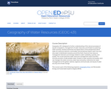
Geography 431 is designed to further understanding of the natural processes of …
Geography 431 is designed to further understanding of the natural processes of aquatic ecosystems, management of water resources, and threats to sustaining water quantity. Develop awareness and appreciation of the perspectives about water as a precious resource, commodity, and sometimes hazard. Learn how and why water is distributed unevenly around the Earth. Examine how resource management decisions are strongly related to water availability, quantity, and quality. The course examines water resources management; dams and dam removal; provision of safe potable water; threats to water quantity and quality; land use changes; the water economy; water laws and policy; institutions for water management at the global, national, regional, and local scale; and issues of water security and climate change.
Geo-information has proven to be extremely helpful in many aspects of risk …
Geo-information has proven to be extremely helpful in many aspects of risk and disaster management: locational and situational awareness, monitoring of hazards, damage detection, sharing of information, defining vulnerability areas, etc. This course aims to provide knowledge on risk and disaster management activities, demonstrate use of geo-information technologies in emergency response, outline current challenges and motivate young geo-specialist to seek for advanced solutions. The course is organised as lectures and practicals. The practicals will be in the form of group assignments. Some excursions and guest lectures will be organised as well.
This lab is part of a Lunar and Planetary Geology course offered …
This lab is part of a Lunar and Planetary Geology course offered to both geology and non-geology majors, and it involves basic geological mapping of an area within the Tyrrhena Patera region on Mars. Students are encouraged to work in groups to prepare a geological map from a photomosaic map and to interpret the geologic stratigraphy from a geological map of the greater area. This activity reinforces mapping skills as well as group work skills, and aims to teach students more about Martian stratigraphy and geology through a hands-on activity.
(Note: this resource was added to OER Commons as part of a batch upload of over 2,200 records. If you notice an issue with the quality of the metadata, please let us know by using the 'report' button and we will flag it for consideration.)
This was an assignment for students in two parts: (1) for a …
This was an assignment for students in two parts:
(1) for a given week, students sign up for a landform that pertains to the processes we’ll be studying (e.g. landslides, streams, volcanoes, etc…). The student will use wikipedia, govt. agency websites, or primary sources to present a “show and tell” of the landform including 4 things: a) describe the process by which that feature is formed, b) give an example of where it can be found, c) find 3 pictures of the landform, & d) sketch (or find a depiction) of what the feature would look like on a topographic contour map.
(2) Students will take their presentations and use them to create pages on a Google Sites webpage that will become an online textbook. Students will be able to use the book to study for quizzes on the landforms.
(3) Students will read and leave comments on 2 other students’ pages to provide constructive feedback to help improve the textbook’s content and readability.
Learning Objectives: Students gain oral and written communication skills by presenting and documenting/sharing their research. Students will describe the shape of landforms and connect landforms with the processes responsible for their formation by learning from each other and from doing their own research.
Geographic Intelligence (GEOINT) is more than people working with computers in a …
Geographic Intelligence (GEOINT) is more than people working with computers in a secure intelligence facility. Join us for this exciting journey to learn about GEOINT's application in business, law enforcement, and defense. Advances in satellites, GPS, unmanned aerial systems, wireless communications, handheld computing, and the ability to automate laborious map analysis processes has transformed what used to be called geographic intelligence, or GEOINT, and the nature of the insights provided to managers and leaders. We have gone from mountains of hardcopy maps to amazing automated systems that provide previously unavailable understanding. GEOINT combines geographic information science and technologies with an analytic tradecraft. You will experience the value of GEOINT. We welcome you to the Revolution.
In GEOG 871, we'll take a critical look at geospatial project management. …
In GEOG 871, we'll take a critical look at geospatial project management. Project management is a broad discipline that encompasses technical methods such as system design and analysis and also interpersonal factors that affect professional relationships. Project management is also a discipline that has matured outside of, but can be incorporated into, geospatial technology. By the end of this course, you'll have devised a project plan from a scenario built upon a real-life project involving the city of Metropolis geodatabase. We'll work through each of the components in an organized and logical manner and will incorporate constructive peer review to help everyone achieve the best product possible.
The Council on Foreign Relations (CFR) and National Geographic commissioned a survey …
The Council on Foreign Relations (CFR) and National Geographic commissioned a survey to gauge what young people educated in American colleges and universities know about geography, the environment, demographics, U.S. foreign policy, recent international events, and economics. The survey, conducted in May 2016 among 1,203 respondents aged eighteen to twenty-six, revealed significant gaps between what young people understand about today’s world and what they need to know to successfully navigate and compete in it. Included on site is the full survey report (PDF) and a sample quiz of some of the survey questions.
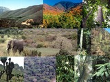
This module focuses on the description of different vetation types that may …
This module focuses on the description of different vetation types that may be of use as part of an introductory physical geography course (biogeography), or for a class focused on the study of plants and vegetation. All images were collected from travels to learn about vegetation over the past 40 years and I openly make them available through the OER site. The resources attached to the module include:I. Description of terms used to describe and distinguish among global vegetation types (biomes)- descriptive notes and imagesII. Tropical Vegetation Types- descriptive notes and powerpoint slide showIIIl Subtropical_Temperate_Arctic Vegetation Types- descriptive notes; powerpoint slide show; supportive lists for desert and montane species.
This activity from a Geomorphology course is designed to familiiarize students with …
This activity from a Geomorphology course is designed to familiiarize students with using Google Earth, as well as making the connection between features they see in a map or satellite view vs. what they might see from ground level. Students will use this exercise as the first of several where they will evaluate landforms and the materials and processes responsible for their development.
This lab is designed to help students apply hillslope diffusion equations (derived …
This lab is designed to help students apply hillslope diffusion equations (derived in class prior to the lab) to understand real-world hillslopes. The major goal is a deeper understanding of hillslope processes and the equations used to describe hillslope diffusion by observing the same factors described in the equations on real-world hillslopes.
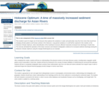
This is one component of the Source to Sink Mini Lesson Set …
This is one component of the Source to Sink Mini Lesson Set This module is part of a larger set of mini-lessons that explores the variations in water and particulate mass flux from rivers that result from changing climate patterns and human activity in the Holocene. Long-period variations in runoff will be explored in this module on the Holocene Climatic Optimum, when intensification of the Southwest monsoon affected massively increased river discharge in South Asia. The exercise will detail the operation of the Asian monsoon and interpret stratigraphic evidence for increased sediment discharge during the Holocene Climatic Optimum using the Ganges-Brahmaputra as an example.
Geography 430 is an active, creative learning community focused around understanding the …
Geography 430 is an active, creative learning community focused around understanding the changing relationships between people and their environments, the causes and consequences of environmental degradation, strategies for building a more sustainable world, and the methods and approaches that scholars have used to understand human-environment interactions. The primary course objectives are to help geographers, earth scientists, and other professionals to deepen their appreciation for the complexity of human-environment systems and to develop skills that allow them to interpret, analyze, and communicate effectively regarding human-environment interactions in their lives as students, professionals, and citizens.
No restrictions on your remixing, redistributing, or making derivative works. Give credit to the author, as required.
Your remixing, redistributing, or making derivatives works comes with some restrictions, including how it is shared.
Your redistributing comes with some restrictions. Do not remix or make derivative works.
Most restrictive license type. Prohibits most uses, sharing, and any changes.
Copyrighted materials, available under Fair Use and the TEACH Act for US-based educators, or other custom arrangements. Go to the resource provider to see their individual restrictions.