Students take on the role of geographers and civil engineers and use …
Students take on the role of geographers and civil engineers and use a device enabled with the global positioning system (GPS) to locate geocache locations via a number of waypoints. Teams save their data points, upload them to geographic information systems (GIS) software, such as Google Earth, and create scale drawings of their explorations while solving problems of area, perimeter and rates. The activity is unique in its integration of technology for solving mathematical problems and asks students to relate GPS and GIS to engineering.
In this lesson, students learn how to determine location by triangulation. We …
In this lesson, students learn how to determine location by triangulation. We describe the process of triangulation and practice finding your location on a worksheet, in the classroom, and outdoors.
Students use graph theory to create social graphs for their own social …
Students use graph theory to create social graphs for their own social networks and apply what learn to create a graph representing the social dynamics found in a dramatic text. Students then derive meaning based on what they know about the text from the graphs they created. Students learn graph theory vocabulary, as well as engineering applications of graph theory.
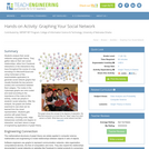
Students analyze their social networks using graph theory. They gather data on …
Students analyze their social networks using graph theory. They gather data on their own social relationships, either from Facebook interactions or the interactions they have throughout the course of a day, recording it in Microsoft Excel and using Cytoscape (a free, downloadable application) to generate social network graphs that visually illustrate the key persons (nodes) and connections between them (edges). The nodes in the Cytoscape graphs are color-coded and sized according to the importance of the node (in this activity, nodes are people in students' social networks). After the analysis, the graphs are further examined to see what can be learned from the visual representation. Students gain practice with graph theory vocabulary, including node, edge, betweeness centrality and degree on interaction, and learn about a range of engineering applications of graph theory.
The marine environment is unique and requires technologies that can use sound …
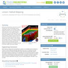
The marine environment is unique and requires technologies that can use sound to gather information since there is little light underwater. The sea-floor is characterized using underwater sound and acoustical systems. Current technological innovations are allowing scientists to further understand and apply information about animal locations and habitat. Remote sensing and exploration with underwater vehicles allows scientists to map and understand the sea floor, and in some cases, the water column. In this lesson, the students will be shown benthic habitat images produced by GIS. These imaged will lead to a class discussion on why habitat mapping is useful and how current technology works to make bathymetry mapping possible. The teacher will then ask inquiry-based questions to have students brainstorm about the importance of bathymetry mapping.
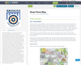
Home Town Map (art + social studies) As basic as it seems, …
Home Town Map (art + social studies) As basic as it seems, young children need to be taught to be observant and aware of their surroundings. This lesson plan helps children in grades K–3 pay more attention to the world around them as they travel back and forth between their homes and their schools. As they create maps of their route, they’ll learn about distance, signs, symbols, landmarks and other things that will reinforce the quickest — and safest — way for them to get to school and back home again. As their classroom teacher or art teacher, you can help your students identify familiar landmarks and create images that reinforce what they already know about their daily journey.
Older students can build more details into their maps, such as weather maps or treasure maps, as well as more complex legends, keys and measurements. Whatever the age of your students, you can help them make this exercise fun!
Both groups of students can take advantage of free city maps and state maps provided by the Department of Transportation and state agencies. Phone books also often include city maps and historical maps. Students will learn that map-making and map-reading can be fun as they trace rivers, parks and the world outside their home and school.
Grade Levels K-6
Note: instructions and materials based on a class of 25 students. Adjust as needed.
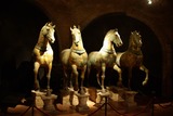
The Horses of Saint Mark have a long itinerary through space and …
The Horses of Saint Mark have a long itinerary through space and time. On this lesson, we will through the visualisation of their whole itinerary to make the students of their relation with powerful states on their whole history.
Comment naviguer le métro parisien? Have you ever been lost in another …
Comment naviguer le métro parisien? Have you ever been lost in another city, another country? How would you ask for directions? Would you know how to navigate the French Metro to get from point A to point B? This activity relates to the theme of directions, navigation. Students will use their prior knowledge of vocabulary related to this theme, as well as the imperative form of verbs. Also, most likely students have all experienced being lost in a new city - it is less likely now because of cell phones and satellite maps. However, taking the wrong subway train, going in the wrong direction in a street can still happen regardless of cell phone availability. This activity teaches students how to ask and give directions in the imperative form.
Historically, seafloor mapping occurred with a simple data collection method: soundings. Soundings …
Historically, seafloor mapping occurred with a simple data collection method: soundings. Soundings are taken by dropping a weight with a pre-measured rope off the side of a boat and noting the measurement on the rope when the weight hits the bottom. In this activity, student teams replicate the creation of seafloor bathymetry by taking a simplified form of soundings of an unseen seafloor model inside a shoebox and translating their collected data into a visualization of the topography, enabling them to better understand and appreciate modern remote sensing.
Students are introduced to the concept of tracking and spatial movements of …
Students are introduced to the concept of tracking and spatial movements of animals in relation to the environments in which they live. Students improve their understanding of animal tracking and how technology is used in this process.
De todos os dados obtidos na pesquisa de Mestrado, geramos o Mapa …
De todos os dados obtidos na pesquisa de Mestrado, geramos o Mapa que representa a realidade mais próxima que temos com relação a presença de cursos, projetos e programas sobre educação ambiental e educomunicação no Território de Identidade da Chapada Diamantina. Os projetos são vinculados às escolas municipais e estaduais presentes nos municípios, a iniciativas privadas, a ONGs, a grupos sociais, à UNEB-Seabra, ao IFBA-Seabra e outras ações do Governo (Estadual e/ou Federal).
The past decade has seen an explosion of new mechanisms for understanding …
The past decade has seen an explosion of new mechanisms for understanding and using location information in widely-accessible technologies. This Geospatial Revolution has resulted in the development of consumer GPS tools, interactive web maps, and location-aware mobile devices. This course brings together core concepts in cartography, geographic information systems, and spatial thinking with real-world examples to provide the fundamentals necessary to engage with Geographic Information Science. We explore what makes spatial information special, how spatial data is created, how spatial analysis is conducted, and how to design maps so that they're effective at telling the stories we wish to share. To gain experience using this knowledge, we work with the latest mapping and analysis software to explore geographic problems.
The marine environment is unique and because little light penetrates under water, …
The marine environment is unique and because little light penetrates under water, technologies that use sound are required to gather information. The seafloor is characterized using underwater sound and acoustical systems. Current technological innovations enable scientists to further understand and apply information about animal locations and habitat. Remote sensing and exploration with underwater vehicles enables researchers to map and understand the sea floor. Similar technologies also aid in animal tracking, a method used within science and commercial industries. Through inquiry-based learning techniques, students learn the importance of habitat mapping and animal tracking.
MASLab (Mobile Autonomous System Laboratory), also known as 6.186, is a robotics …
MASLab (Mobile Autonomous System Laboratory), also known as 6.186, is a robotics contest. The contest takes place during MIT's Independent Activities Period and participants earn 6 units of P/F credit and 6 Engineering Design Points. Teams of three to four students have less than a month to build and program sophisticated robots which must explore an unknown playing field and perform a series of tasks. MASLab provides a significantly more difficult robotics problem than many other university-level robotics contests. Although students know the general size, shape, and color of the floors and walls, the students do not know the exact layout of the playing field. In addition, MASLab robots are completely autonomous, or in other words, the robots operate, calculate, and plan without human intervention. Finally, MASLab is one of the few robotics contests in the country to use a vision based robotics problem.
Normally we find things using landmark navigation. When you move to a …
Normally we find things using landmark navigation. When you move to a new place, it may take you awhile to explore the new streets and buildings, but eventually you recognize enough landmarks and remember where they are in relation to each other. However, another accurate method for locating places and things is using grids and coordinates. In this activity, students will come up with their own system of a grid and coordinates for their classroom and understand why it is important to have one common method of map-making.
This resource is a video abstract of a research paper created by …
This resource is a video abstract of a research paper created by Research Square on behalf of its authors. It provides a synopsis that's easy to understand, and can be used to introduce the topics it covers to students, researchers, and the general public. The video's transcript is also provided in full, with a portion provided below for preview:
"Despite advances in therapy, the prognosis and survival of patients with glioblastoma remain dismal. Part of the reason is poor targeting. The sheer complexity of tumor growth at the molecular scale makes it difficult to pinpoint the origin of gliomas. In recent years, more targeted research has led to the discovery of chains of molecular events that regulate glioma development, including the unusual trafficking of proteins into the nucleus of glioma cells. In a new study, researchers examined this glioma-related behavior for the protein doublecortin (DCX). DCX is a neuronal protein crucial for the formation of new neurons in adulthood and for neuronal migration. While researchers have looked at how glioma cells shuttle different proteins to their nucleus, this marked the first time that scientists zeroed in on DCX. The team found that high accumulation of DCX in the nucleus boosted the invasiveness of glioma cells, whereas blocking the nuclear import of DCX reduced glioma proliferation..."
The rest of the transcript, along with a link to the research itself, is available on the resource itself.
No restrictions on your remixing, redistributing, or making derivative works. Give credit to the author, as required.
Your remixing, redistributing, or making derivatives works comes with some restrictions, including how it is shared.
Your redistributing comes with some restrictions. Do not remix or make derivative works.
Most restrictive license type. Prohibits most uses, sharing, and any changes.
Copyrighted materials, available under Fair Use and the TEACH Act for US-based educators, or other custom arrangements. Go to the resource provider to see their individual restrictions.