Students collect a soil near their house or other location, analyze it …
Students collect a soil near their house or other location, analyze it using grain size, plot the locations and collectively create a soils map of campus or larger area. This exercise can be tailored for many different grade levels. I've used it from 4th grade through Physical Geology classes
This class focuses on representation tools used by architects during the design …
This class focuses on representation tools used by architects during the design process and attempts to discuss the relationship they develop with the object of design. Representation plays a key role in architectural design, not only as a medium of conveying and narrating a determined meaning or a preconceived idea, but also as a code of creating new meaning, while the medium seeks to establish a relationship with itself. In this sense, mediums of representation, as external parameters to the design process, are not neutral tools of translating an idea into its concrete form. They are neither authentic means of creativity, nor vapid carriers of an idea. Therefore, an important aspect in issues of meaning is how the architect manipulates the play of translating a concept to its concrete version, through the use of a medium of representation. The course is a continuation of the equivalent course taught in the fall semester and specifically focuses on digital media. The course is intended to establish a reciprocal relationship with the design studio, feeding from and contributing to its content.
This book provides an introduction, at academic level, into the field of …
This book provides an introduction, at academic level, into the field of surveying and mapping. The book has been compiled based on hand-outs and readers written for the third-year course Surveying and Mapping, in the bachelor program Civil Engineering at Delft University of Technology. This book covers a wide range of measurement techniques, from land surveying, GPS/GNSS and remote sensing to the associated data processing, the underlying coordinate reference systems, as well as the analysis and visualization of the acquired geospatial information.
This learning video presents an introduction to graph theory through two fun, …
This learning video presents an introduction to graph theory through two fun, puzzle-like problems: ''The Seven Bridges of Konigsberg'' and ''The Chinese Postman Problem''. Any high school student in a college-preparatory math class should be able to participate in this lesson. Materials needed include: pen and paper for the students; if possible, printed-out copies of the graphs and image that are used in the module; and a blackboard or equivalent. During this video lesson, students will learn graph theory by finding a route through a city/town/village without crossing the same path twice. They will also learn to determine the length of the shortest route that covers all the roads in a city/town/village. To achieve these two learning objectives, they will use nodes and arcs to create a graph and represent a real problem.
This course proposes that investigating the ways in which territory is produced, …
This course proposes that investigating the ways in which territory is produced, maintained and strategized, generates conflicts, establishes divisions, and builds identities can lead to a more critical understanding of architecture's role in society. This course is designed to expand the student's literacy in the concept of territory and its relation to the realm of architecture.
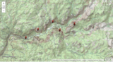
Interpret properties of the landscape using topographic maps of well-known national parks. …
Interpret properties of the landscape using topographic maps of well-known national parks. Direct link on ArcGIs. THE EARTH SCIENCE GEOINQUIRY COLLECTIONhttp://www.esri.com/geoinquiriesThe Earth Science GeoInquiry collection contains 15 free, web-mapping activities that correspond and extend map-based concepts in leading middle school Earth science textbooks. The activities use a standard inquiry-based instructional model, require only 15 minutes for a teacher to deliver, and are device agnostic. The activities harmonize with the Next Generation Science Standards. Activity topics include:• Topographic maps• Remote sensing• Minerals / Mining• Rock Types• Landforms• Plate tectonics• Earthquakes• Volcanoes• Mountain building• Fresh water• Ocean features• Ground wind and temperature patterns• Weather• Storms• Climate change
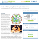
Students analyze dramatic works using graph theory. They gather data, record it …
Students analyze dramatic works using graph theory. They gather data, record it in Microsoft Excel and use Cytoscape (a free, downloadable application) to generate graphs that visually illustrate the key characters (nodes) and connections between them (edges). The nodes in the Cytoscape graphs are color-coded and sized according to the importance of the node (in this activity nodes represent characters in the work and their relative importance to the story). After the analysis, the graphs are further examined to see what the visual depiction of the story in the form of a graph tells readers about the inner workings of the dramatic work. Students gain practice with graph theory vocabulary, including node, edge, betweeness centrality and degree on interaction, and learn about a range of engineering applications of graph theory.
This activity is an inquiry based field investigation where students measure and …
This activity is an inquiry based field investigation where students measure and map a small stream and then develop an understanding of the formation of a variety of small stream features.
Geographic information systems (GIS) are important technology that allows rapid study and …
Geographic information systems (GIS) are important technology that allows rapid study and use of spatial information. GIS have become increasingly prevalent in industry and the consumer/internet world in the last 20 years. Historically, the basis of GIS was in mapping, and so it is important to understand the basis of maps and how to use them as well as why they are different from GIS. In this lesson, students learn the value of maps, how to use maps, and the basic components of a GIS. They are also introduced to numerous GIS applications.
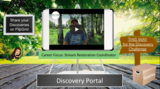
Every step we take is in a watershed. Let's learn more about …
Every step we take is in a watershed. Let's learn more about them! Check out the Stream Restoration Coordinator video to learn how scientists help improve stream health. Then, in the Discovery Challenge video, observe, investigate, and record information about your watershed from a distance and then really close up . Then, after learning a little more about watersheds, we will create models of watersheds and use those models to investigate how soil and chemicals might move through our watersheds.
This lesson introduces NGSS standards, and those standards are listed in the lesson and is part of the Explore Science Club series, an online Career Connected Learning program developed by the Greater Oregon STEM Hub. To learn more find us at: www.go-stem.org.
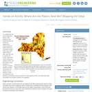
In a student-led and fairly independent fashion, data collected in the associated …
In a student-led and fairly independent fashion, data collected in the associated field trip activity are organized by student groups to create useful and informative Google Earth maps. Each team creates a map, uses that map to analyze the results, adjusts the map to include the analysis results, and then writes a brief summary of findings. Primarily, questions of fate-and-transport of plastics are are explored. If data was gathered in the field trip but the teacher does not desire to do the mapping activity, then alternative data presentation and analysis methods are suggested.
No restrictions on your remixing, redistributing, or making derivative works. Give credit to the author, as required.
Your remixing, redistributing, or making derivatives works comes with some restrictions, including how it is shared.
Your redistributing comes with some restrictions. Do not remix or make derivative works.
Most restrictive license type. Prohibits most uses, sharing, and any changes.
Copyrighted materials, available under Fair Use and the TEACH Act for US-based educators, or other custom arrangements. Go to the resource provider to see their individual restrictions.