The most comprehensive atlas of world history online! A free atlas of …
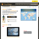
The most comprehensive atlas of world history online!
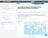
A free atlas of world history with over 1,000 maps and articles to connect the history world into one navigable resources. Use it to navigate maps and summaries of world nations throughout their histories; see what was happening around the world at a specific point of history; or understand the connections between places and events. The TimeMap comes with teaching activities and lesson plans.
It also contains background essays on regions, time periods and civilizations, making it a great resources to understand the context of history.
The main aims of this seminar will be to go over the …
The main aims of this seminar will be to go over the classification of surfaces (Enriques-Castelnuovo for characteristic zero, Bombieri-Mumford for characteristic p), while working out plenty of examples, and treating their geometry and arithmetic as far as possible.
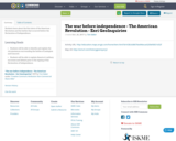
The Civil War, from 1861 to 1865, is the centerpiece of our …
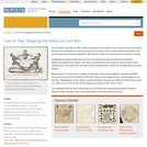
The Civil War, from 1861 to 1865, is the centerpiece of our nation's story. It looms large, not merely because of its brutality and scope but because of its place in the course of American history. The seeds of war were planted long before 1861 and the conflict remains part of our national memory. Geography has helped shape this narrative. The physical landscape influenced economic differences between the regions, the desire to expand into new territories, the execution of the conflict both in the field and on the home front, and the ways in which our recollections have been shaped. Maps enable us to present the complex strands that, when woven together, provide a detailed account of the causes and conduct of the war. These visual images remain a salient aspect of our memory. Photographs, prints, diaries, songs and letters enhance our ability to tell this story, when our nation, as a Currier & Ives cartoon depicts, was about to be "Torn in Two." This exhibition tells the story of the American Civil War both nationally and locally in Boston, Massachusetts, through maps, documents, letters, and other primary sources. This exhibition was developed by the Norman B. Leventhal Map Center, a nonprofit organization established as a partnership between the Boston Public Library and philanthropist Norman Leventhal.
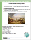
The unit has two parts. In each, students dive into inquiry to …
The unit has two parts. In each, students dive into inquiry to answer the compelling questions:
1. Who are some of our closest tribal neighbors, and what have they been their lifeways since time immemorial? 2. Why do people explore, and how does this lead to expansion?
Part 1 is focused on the examination of the northwest and some of the original inhabitants. Through these questions students will learn about the culture of some of their closest tribal neighbors, the Spokane Indians. The final project for Part 1 is a cultural investigation display, in which students will show what they know about the culture of the Spokane Tribe.
In Part 2, Students will also learn about forces that brought change to the northwest: fur trade era and exploration. Students will ultimately learn about the Corps of Discovery and the Oregon Trail and know the impact each had on the west. Students will finish Part 2 with a timeline activity that will reflect choice and build upon student strengths according to their skill set.
Finally, a lesson on a Tribe of the Columbia Plateau is offered as an extension, but it is strongly recommended that students get to experience this lesson.
Note that the emphasis here is on the Spokane Tribe as one of our closest tribal neighbors. In no way is this an exhaustive study nor should the tribal cultures be generalized to other tribes of the region. We understand that each tribe in our region and North America was and continues to be unique in its culture, practices, lifeways, and traditions.
In this activity, students work with measurement and shapes using live web …
In this activity, students work with measurement and shapes using live web maps and images of the Earth at various scales using ArcGIS Online. Time required: 2 class periods (100 minutes total).
In this seminar we explore the history, present, and future of psychogeography, …
In this seminar we explore the history, present, and future of psychogeography, hoping to map the center and the edges of this elusive field and to pioneer potential new directions and applications for the principles we discover (or invent) along the way. We discuss classic and more recent texts—including novels, essays, poems, reviews, films, and other works of creative nonfiction and speculative fiction. Students also undertake their own psychogeographic wanderings and complete a final “carto-imagino-synthetic” project to document, describe, map, and otherwise “make sense of place” through these techniques.
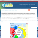
This article points out that there is no one official definition for …
This article points out that there is no one official definition for the Arctic. Then the author identifies definitions ranging from geography to climate to culture and more. Maps and other visuals illustrate the definitions. The author suggests that defining the Arctic can be an example for K-Grade 5 students of the nature and challenges of classification systems. The article appears in the free, online magazine Beyond Penguins and Polar Bears.
No restrictions on your remixing, redistributing, or making derivative works. Give credit to the author, as required.
Your remixing, redistributing, or making derivatives works comes with some restrictions, including how it is shared.
Your redistributing comes with some restrictions. Do not remix or make derivative works.
Most restrictive license type. Prohibits most uses, sharing, and any changes.
Copyrighted materials, available under Fair Use and the TEACH Act for US-based educators, or other custom arrangements. Go to the resource provider to see their individual restrictions.