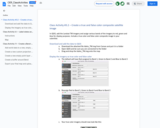
Preparation for this activity is done during the class discussion on current …
Preparation for this activity is done during the class discussion on current events. Prior to this class, students are required to look through the newspapers and browse the internet for a list of events. During the class, student groups share their list with the class. Each group then categorizes the larger list. This discussion is extremely useful for shedding light on the connectivity and complexity of human relationships from the individual to nations. Students are then asked to propose why these current events are occurring. For example, immigrant students in my course discuss scarcity of resources leading to conflict and civil war in their home countries. Other students will bring the idea of global economy and the effects of globalization on their cultures. The discussions that emerge from this activity are significant for all students involved. In addition to increased student awareness, this activity underscores the importance of integrated learning. Uses geophysics to solve problems in other fields
In this activity, students will use oxygen isotope values of two species …
In this activity, students will use oxygen isotope values of two species of modern coral to reconstruct ambient water temperature over a four-year period. They use Microsoft Excel, or similar application, to create a spreadsheet of temperature values calculated from the isotope values of the corals by means of an algebraic equation. Students then use correlation and regression techniques to determine whether isotope records can be considered to be good proxies for records of past temperatures.
Course Description:GEO 212. Introduction to Meteorology (4 credit hour). Physical and chemical …
Course Description:GEO 212. Introduction to Meteorology (4 credit hour). Physical and chemical conditions that regulate global weather phenomena. Includes structure of the atmosphere, temperature, humidity, air pressure and winds, the development of weather systems, tornadoes and hurricanes, and the parameters that affect local and global climate. Laboratory includes image interpretation, field observation and prediction. This is formatted as an 8 week/module course.Learning Outcomes:1. Describe the origin and structure of the earth and its atmosphere. (1, 7)2. Use scientific reasoning to explain the relationship between the earth and sun and how solarand terrestrial radiation affects temperature, air pressure and wind patterns. (1, 2, 7, 8)3. Explain the role of heat, moisture and winds in generating clouds, precipitation and severeweather. (2-6, 8)4. Model major atmospheric circulation systems and oscillations. (1-8)5. Describe climatic regions and assess climate change predictions. (1-8)6. Interpret meteorological data to predict weather conditions. (1-8)
The goal of these class activities is to help students interpret maps …
The goal of these class activities is to help students interpret maps and associated data. The first activity highlights underinvestment in disadvantaged communities across the United States. The second activity explores women’s rights and inequality from a global perspective.
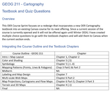
This OER Course Sprint focuses on a redesign that incorporates a new …
This OER Course Sprint focuses on a redesign that incorporates a new OER Cartography textbook into an existing Canvas course for its next offering. Since a current session of the course is currently opened and it will not be offered again until Winter 2024, I have created multiple choice questions to go with the textbook chapters and will add them to Canvas when the current section ends.
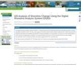
The Digital Shoreline Analysis System (DSAS) is a software extension for ArcGIS …
The Digital Shoreline Analysis System (DSAS) is a software extension for ArcGIS that allows for automated shoreline change calculations along the coast. The user must supply the shoreline data and the software helps the user create measurement locations (transects) and completes the shoreline change calculations at each location. The result is a visual representation of the shoreline change along a coastline. This representation is far more useful for analysis that one overall average. Unusually high rates of erosion/accretion are easily recognized from the resulting map. The study location is Rodanthe, NC. The data used in this exercise is the sample data provided by the USGS.
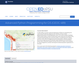
In GEOG 489, you will learn advanced applications of Python for developing …
In GEOG 489, you will learn advanced applications of Python for developing and customizing GIS software, designing user interfaces, solving complex geoprocessing tasks, and leveraging open source. The course consists of readings, walkthroughs, projects, quizzes, and discussions about advanced GIS programming concepts and techniques, and a final term project. It complements the material covered in GEOG 485: GIS Programming and Customization. Software covered in the course includes: Esri ArcGIS Pro/arcpy, Jupyter Notebook, Esri ArcGIS API for Python, QGIS, GDAL/OGR. Students will also use of the Git version control software for code management, and learn techniques for distributing Python applications to end users.
This is not a typical e-book; it is a free, web-based, open-source …
This is not a typical e-book; it is a free, web-based, open-source “textbook” available to anyone interested in using mapping tools to create maps. This e-text focuses primarily on Geographic Information Systems (GIS)—a geospatial technology that enables you to create spatial databases, analyze spatial patterns, and produce maps that communicate more effectively. While this GIS textbook is principally an introduction to GIS, most of the chapter’s concepts are applicable to other geotechnologies including remote sensing, global positioning systems (GPS), Internet mapping, and virtual globes.
Creating good maps and analyzing spatial data is a time consuming and challenging practice, but recently, a new set of powerful mapping tools has enabled almost anyone with a computer to make maps easily and to perform at least some low-level analyses. The results, however, are not encouraging. Most of the new mapmakers do not have adequate training in mapping concepts and spatial analysis principles, and their maps are often improperly designed and do not communicate easily nor effectively. This e-text—GIS Commons—seeks to help you analyze spatial data and communicate more effectively. In short, GIS education is our goal.
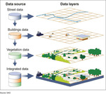
A geographic information system (GIS) is a computer system for capturing, storing, …
A geographic information system (GIS) is a computer system for capturing, storing, checking, and displaying data related to positions on Earth’s surface.
This resource was created as part of a project to develop open-access …
This resource was created as part of a project to develop open-access lab notes for the University of Ottawa's "GIS and the Digital Earth" course and its French counterpart "SIG et la Terre numérique". It contains lab notes for five labs with exercises for this introductory course, as well as the data needed for students to work through the labs. All labs are based on ArcGIS Pro, and requires students to have access to this software.
This is a freshman advising seminar. The professor of a FAS is …
This is a freshman advising seminar. The professor of a FAS is the first year advisor to the (no more than 8) students in the seminar. The use of Global Positioning System (GPS) in a wide variety of applications has exploded in the last few years. In this seminar we explore how positions on the Earth were determined before GPS; how GPS itself works and the range of applications in which GPS is now a critical element. This seminar is followed by a UROP research project in the spring semester where results from precise GPS measurements will be analyzed and displayed on the Web.
The GeoTech Center, a National Science Foundation grant to support geospatial programs …
The GeoTech Center, a National Science Foundation grant to support geospatial programs at two-year colleges, developed Model Courses focused on building the skills, competencies, and abilities needed for entry-level occupations in the geospatial industry. Competencies covered in the Model Courses were identified using the Geospatial Technology Competency Model (GTCM) and outcomes from multiple DACUM (“Developing a Curriculum”) events. A panel of geospatial education experts parsed the competencies into the Model Courses for the Certificate and are listed in a Program Content Tool that can be used to see what competencies and depth should be in each course. You can also assess your program from the GTCM Program Assessment Tool tool. All material is distributed freely under a Creative Commons license and can be used with attribution to GeoTech.
A good detective or researcher like Sherlock Holmes knows the fundamental questions …
A good detective or researcher like Sherlock Holmes knows the fundamental questions that need to be answered to gather facts to solve a problem. So how does geospatial intelligence contribute to answering these questions? While geospatial technology is useful in revealing who, what, when, and where events take place, it is less useful in explaining why events occur. However, geospatial intelligence analysis leverages geographic information science and technology with the intelligence tradecraft to develop products that support decision-making in national and homeland security, law enforcement, emergency management, and international relief efforts. GEOG 882 will challenge you to think critically, consider alternative viewpoints, and question your own assumptions when analyzing why human events occur over place and time.
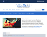
In this data rich world, we need to understand how things are …
In this data rich world, we need to understand how things are organized on the Earth's surface. Those things are represented by spatial data and necessarily depend upon what surrounds them. Spatial statistics provide insights into explaining processes that create patterns in spatial data. In geographical information analysis, spatial statistics such as point pattern analysis, spatial autocorrelation, and spatial interpolation will analyze the spatial patterns, spatial processes, and spatial association that characterize spatial data. Understanding spatial analysis will help you realize what makes spatial data special and why spatial analysis reveals a truth about spatial data.
Essentials of Geographic Information Systems integrates key concepts behind the technology with …
Essentials of Geographic Information Systems integrates key concepts behind the technology with practical concerns and real-world applications. Recognizing that many potential GIS users are nonspecialists or may only need a few maps, this book is designed to be accessible, pragmatic, and concise. Essentials of Geographic Information Systems also illustrates how GIS is used to ask questions, inform choices, and guide policy. From the melting of the polar ice caps to privacy issues associated with mapping, this book provides a gentle, yet substantive, introduction to the use and application of digital maps, mapping, and GIS.
DESCRIPTION Introduces students to the theory and methods of remote sensing through use of satellite imagery. Practical exercises involve use of SPOT, LANDSAT and Quickbird images with ArcGIS/Imagine Analysis software. Digital analysis is discussed and performed including preprocessing, image classification and image evaluation. Intended for students enrolled in the second year of GIS or UAS programs, or similar academic preparation (see program director for details).
LEARNING OUTCOMES 1. Demonstrate knowledge and apply skills essential to the discipline. 2. Apply GIS skills necessary to provide geospatial and thematic data. 3. Apply critical thinking and problem solving skill that reflect best practice. 4. Coordinate and manage the delivery of reliable, valid, GIS data including analysis and specialized user needs products. 5. Communicate effectively and appropriately within a professional setting in both written and oral form.
No restrictions on your remixing, redistributing, or making derivative works. Give credit to the author, as required.
Your remixing, redistributing, or making derivatives works comes with some restrictions, including how it is shared.
Your redistributing comes with some restrictions. Do not remix or make derivative works.
Most restrictive license type. Prohibits most uses, sharing, and any changes.
Copyrighted materials, available under Fair Use and the TEACH Act for US-based educators, or other custom arrangements. Go to the resource provider to see their individual restrictions.