
In this lesson, students will work on their literary analysis paper, focusing on the thesis. They will also spend time on their group research project.
- Subject:
- English Language Arts
- Material Type:
- Lesson Plan
- Date Added:
- 09/21/2015

In this lesson, students will work on their literary analysis paper, focusing on the thesis. They will also spend time on their group research project.

The 12th grade learning experience consists of 7 mostly month-long units aligned to the Common Core State Standards, with available course material for teachers and students easily accessible online. Over the course of the year there is a steady progression in text complexity levels, sophistication of writing tasks, speaking and listening activities, and increased opportunities for independent and collaborative work. Rubrics and student models accompany many writing assignments.Throughout the 12th grade year, in addition to the Common Read texts that the whole class reads together, students each select an Independent Reading book and engage with peers in group Book Talks. Language study is embedded in every 12th grade unit as students use annotation to closely review aspects of each text. Teacher resources provide additional materials to support each unit.

This project unit—a multimedia self-portrait published in digital form—is the capstone of your students' high school careers. It is a chance for them to pause and reflect on where they've been, where they're going, and who they are as a person. Students will reflect on what they want others to know about them: what they want their message to be and what types of media they might use to convey that message. Students will have the opportunity to express themselves in many different formats—through writing, of course, but also through other media of their choosing. Students will be able to convey your message through visual art, photography, a graphic novel, audio, poetry, or video—practically any type of media they want!
ACCOMPLISHMENTS
Students will complete a multimedia self-portrait, capturing important aspects of the essence of themselves.
Students will contribute one chapter from their multimedia self-portrait to a class anthology.
Students will present one chapter from their multimedia self-portrait to the class.
GUIDING QUESTIONS
These questions are a guide to stimulate thinking, discussion, and writing on the themes and ideas in the unit. For complete and thoughtful answers and for meaningful discussions, students must use evidence based on careful reading of the texts.
How is late adolescence a moment of internal and external change?
What are the most important qualities of your character—past, present, and future?
How can you portray these key aspects of yourself using multimedia?
BENCHMARK ASSESSMENT: Cold Read
During this unit, on a day of your choosing, we recommend you administer a Cold Read to assess students’ reading comprehension. For this assessment, students read a text they have never seen before and then respond to multiple-choice and constructed-response questions. The assessment is not included in this course materials.

What does a multimedia memoir look like? Students will continue to explore website-creation or portfolio platforms they can use to create and publish their self-portrait. They’ll take a close look at a multimedia story to examine its features and plan the media they will use to express their own work.

How will students explain their work? What do they want their audience to know about their creative process? They’ll look at examples of Artist’s Statements and start to plan their own statement. With the class, they’ll create a checklist of requirements for writing an Artist’s Statement.

Students will review their work, noting any changes that they still need to make. They’ll decide which chapter to include in the class anthology and share it with a peer, getting feedback and suggestions. Then they’ll continue to review and finalize their work.

In this lesson, students will wrap up all the chapters of their self-portrait. They’ll complete a File Map to record the name and location of each of their files so that the files are all accessible when they’re ready to upload them.

What project work so far are students most proud of? They’ll discuss their accomplishments with the class and continue to create, edit, and compile the various chapters of their self-portrait. They’ll also continue to update their planning documents to keep of track of their progress.

It’s time to begin the publication process! Students will learn how to upload their chapters and artifacts to their final self-portrait. As they begin to build their project, they’ll also keep a list of helpful tips for uploading, reviewing, and editing their work.

In this lesson, students will continue to upload their chapters and artifacts, reviewing and editing their work and troubleshooting any problems that arise.
The classic campus-based project is an environmental or sustainability assessment, often referred to as an environmental audit. This course, taught at Carleton in 2001, describes how this type of project can be undertaken. In this scenario, a student, campus environmental group or class researches aspects the envinormental impact of the school.
(Note: this resource was added to OER Commons as part of a batch upload of over 2,200 records. If you notice an issue with the quality of the metadata, please let us know by using the 'report' button and we will flag it for consideration.)
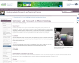
Students cooperatively conduct original research in Marine Geology utilizing marine practices on Lake Champlain, NY - Vermont. The lab section of the course is used to develop and implement a research project. The students are given a research question to solve. To proceed, they must first review all available literature and then design a research program. They then implement that program using marine and laboratory equipment that is available to them and report on their outcomes after a semester-long investigation.
(Note: this resource was added to OER Commons as part of a batch upload of over 2,200 records. If you notice an issue with the quality of the metadata, please let us know by using the 'report' button and we will flag it for consideration.)
The Environment and the Earth class at the University of South Carolina participated in a campus environmental service-learning project where students collected data lighting, water fixtures, recycling bins, and trash in five academic buildings.
(Note: this resource was added to OER Commons as part of a batch upload of over 2,200 records. If you notice an issue with the quality of the metadata, please let us know by using the 'report' button and we will flag it for consideration.)
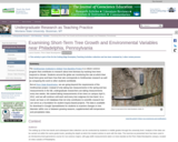
Photo of a tree band at Penn State Brandywine, Media, PA
Provenance: Laura Guertin, Penn State Brandywine
Reuse: This item is offered under a Creative Commons Attribution-NonCommercial-ShareAlike license http://creativecommons.org/licenses/by-nc-sa/3.0/ You may reuse this item for non-commercial purposes as long as you provide attribution and offer any derivative works under a similar license.
The Smithsonian Institution's Global Tree Banding Project is a citizen science program that contributes to research about tree biomass by tracking how trees respond to climate. Students around the globe are monitoring the rate at which their local trees grow and learn how that rate corresponds to Smithsonian research as well as comparing the work to other students worldwide.
But at Penn State Brandywine, we are going beyond the requirements of the Smithsonian project. Instead of only taking two measurements in the spring and two measurements in the fall, undergraduate researchers are taking measurements every two weeks. We started taking measurements of ten trees on campus April 3, 2012, and we will continue until each and every tree outgrows its tree band. As a result, we have a rich database that not only contributes to scientific research but can serve as a foundation for student inquiry-based projects. The data is available for download in Google Spreadsheets for students to examine changes in tree diameter within one or between growing seasons, supplemented with temperature and precipitation data.
(Note: this resource was added to OER Commons as part of a batch upload of over 2,200 records. If you notice an issue with the quality of the metadata, please let us know by using the 'report' button and we will flag it for consideration.)
Students conduct a regional seismic hazard analysis of a region of the United States of their choosing*. Using on-line data, they bring together and investigate the interaction of multiple types of data [ground motion (measured by GPS from UNAVCO), historical earthquake data and fault data] to associate rates of deformation and earthquake activity with hazard potential. Students would develop an assessment of seismic hazard potential. This project also introduces the idea of fault loading and qualitative earthquake interaction.
(Note: this resource was added to OER Commons as part of a batch upload of over 2,200 records. If you notice an issue with the quality of the metadata, please let us know by using the 'report' button and we will flag it for consideration.)
The Florida River Project is a semester-long project involving (1) an individual project in which students pose a scientific question and use existing data to test their hypothesis, and (2) a group project in which students collect and present data associated with stream monitoring.
Outcomes of the individual project include:
- Practice applying the process of science
- Graphing and interpreting data
- Making an argument supported by quantitative evidence.
- Communicating a scientific argument in writing.
- Supporting a scientific argument using appropriate formats (especially graphs and tables)
Outcomes of the group project include:
- Collecting field data (discharge, sediment load, water chemistry)
- Presenting data orally.
- Discussing preliminary interpretations of data.
(Note: this resource was added to OER Commons as part of a batch upload of over 2,200 records. If you notice an issue with the quality of the metadata, please let us know by using the 'report' button and we will flag it for consideration.)
This exercise is designed to present the realistic problems of forecasting weather. Lake effect snows are hard to forecast because they depend on information that isn't part of the regular set of information and involve some pretty specific things that integrate the location of the site with surrounding environment. Even places close by can get totally different forecasts. When you have a regional forecast, it doesn't really address lake effect snows, unless the forecaster really focuses. So the exercise aims to show the value of broad critical thinking in meteorology, and it is very dramatic, because the difference between 36 inches and whiteout and clear blue sky is undeniable. The exercise comes when students are 8 weeks into the class. The class is an AMS based class, which has already been described well in this workshop by Julie Snow from Slippery Rock. Our class is given in the fall semester and lake effect snow starts in October and is quite an issue in forecasts until April. The skills of a forecaster are tested, and you cannot use forecasts from nearby areas reliably. Finally, we live in a fantastic snow belt, so lake effect snow happens a lot. In a good year we get over 300 inches of snow, mostly at times that places nearby do not. You can drive to Houghton in the bright sun and be met by a wall of very active blizzard just a few miles out of town.
There are some excellent tutorials available from COMET, and outreach of the National Weather Service. I use one done by Greg Byrd, which is available online or in a power point format. There are a number of things that must be learned before forecasting. These include some fluid dynamics of plumes, latent heat, remote sensing, upper air mapping, and the use of models. We cannot cover all them completely. I try to introduce all these things and give people entry points into the juicy parts of these topics, but do not expect students to understand completely. One thing you can spend a long time on are the satellite images. Here is one, just to whet your interest: http://serc.carleton.edu/details/images/13586.html
I have the students make a list of the critical parameters they think might be needed for a successful lake effect forecast. This is a challenge to prepare, but the idea is to include things that are even marginally useful and to collect data to see what is most important. We get a list of parameters like this:
850 mb wind direction
850 mb temperature
Lake Superior surface temperature
fetch length
opposing bay?
Inversion layer height
topographic lift factor
wind shear evidence
upstream lake
upstream moisture factor
snow/ice cover issues
This list is pretty good, but deliberately not complete, and we encourage students to add other things they think might be important. The next step is to find where you can get this information. I have web data sources for most (see below), and some of them are interrelated. You can do this exercise for any site around Lake Superior or probably many other lakes as well. For specific sites, the fetch length, upstream lake and opposing bay information are obtainable directly from the wind direction if you have a good map (Google Earth). So a spreadsheet for parameters related to wind direction can be prepared in advance and these parameters can be immediately available from the wind direction. Nonetheless the issue of sources for all this stuff must be addressed in an effort that spans several hours. The use of models is needed to look into the future where possible.
Once students know what they are looking for and how to find it, the exercise starts its data collection. Every day or every 6 or 12 hours beginning when conditions get close to "LES favorable" students collect information on these LES predictors. They also make LES forecasts for each period and include that information in the spreadsheet. The next day the real snowfall data is added to the spreadsheet, and this can be used as validation data for the forecast. This data collection needs to be done for several weeks (November and December in my case, usually a good time for LES).
The data analysis is the most challenging part. Spreadsheet plots which test the sensitivity of various parameters singly and together are possible. There is a lot of sophistication possible if there is enough LES to analyze. Overall, results should be a good experience with imperfect data addressed to a real-time problem. Models and real data, remote sensing, and balloons are all integrated and there are quite obvious weaknesses.
On the final day of class student groups will compete by doing forecasting which employs the LES techniques. This might reflect the most recent snow event. A more important element of this submission will be their evaluation of LES prediction parameters. Not only do we consider the actual forecast, but we discuss which parameters were successful? Which are inconclusive? What suggestions for improved forecasts are possible from the experience? The format of this will be short presentations with time for discussion.
(Note: this resource was added to OER Commons as part of a batch upload of over 2,200 records. If you notice an issue with the quality of the metadata, please let us know by using the 'report' button and we will flag it for consideration.)
Learn more about the amazing world of science by enjoying our fun science experiments, cool facts, online games, free activities, ideas, lesson plans, photos, quizzes, videos & science fair projects.
Science is a fascinating subject, there are many great ideas that will help you make a great science fair project.
Find science games, experiments, facts, projects, videos, quizzes, lessons and images related to the topic of your choice.
Put on your safety glasses & lab coat and get to work on a fun science fair project.
Here's a few of our ideas for science fair projects.

This is a project that follows the general PBL framework that can be used to help students master the concept of intermediate geometry. It was specifically designed to help students review the fundamental theorems of geometry involving lines, segments, angles, and basic shapes; use the properties of similarity and congruence to solve problems for geometric figures; master trigonometric ratios to solve right triangle problems; compare & contrast various geometric transformations and models; learn how to do geometric proofs and construct basic geometric figures; and understand the basic concepts related to the geometry of circles. Note that the project was designed and delivered per the North Carolina Math 2 curriculum and it can be customized to meet your own specific curriculum needs and resources.
This project involved students in in-depth research, thus understanding, of the geological setting of Bozeman. Teams defined the scope of their investigations (with faculty oversight) and delegated tasks to build a knowledge base. This understanding lead to the outreach component -- a poster session to present this knowledge to the campus and broader community. The poster contents were submitted in a digital form as well, with the long-term goal the compilation of a printed poster (suitable for the Chamber of Commerce, for example, to distribute) analogous to those produced for the Geoscape Canada project.
As a hook, I would plan to do a brief pretest on the region involving WHAT students know about the region beforehand and WHY they might need to know. Sample questions: Content: How deep would one have to dig or drill to find groundwater under downtown Bozeman Under the airport?? Significance: Which of the following processes/hazards are made worse by groundwater close to the surface? Earthquakes, Landslides... An advantage to such a pretest would be an end-of-semester reflection exercise including the same test as a post-test.
(Note: this resource was added to OER Commons as part of a batch upload of over 2,200 records. If you notice an issue with the quality of the metadata, please let us know by using the 'report' button and we will flag it for consideration.)