Students learn about the structure of the earth and how an earthquake …
Students learn about the structure of the earth and how an earthquake happens. In one activity, students make a model of the earth including all of its layers. In a teacher-led demonstration, students learn about continental drift. In another activity, students create models demonstrating the different types of faults.
Students learn the two main methods to measure earthquakes, the Richter Scale …
Students learn the two main methods to measure earthquakes, the Richter Scale and the Mercalli Scale. They make a model of a seismograph a measuring device that records an earthquake on a seismogram. Students also investigate which structural designs are most likely to survive an earthquake. And, they illustrate an informational guide to the Mercalli Scale.
In Unit 2 of the Explore the Salish Sea curriculum, students will …
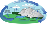
In Unit 2 of the Explore the Salish Sea curriculum, students will review the water cycle, learn the parts of a watershed, and the effects of erosion and pollution, then learn ways of purifying these waters before they enter our streams and estuaries to safeguard these ecosystems for marine life and us. Each unit in this series contains a detailed unit plan, a slideshow, student journal, and assessments. All elements are adaptable and can be tailored to your local community.
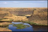
The Fourth Grade Elementary Framework for Science and Integrated Subjects, What Happened …
The Fourth Grade Elementary Framework for Science and Integrated Subjects, What Happened at Dry Falls?, uses the phenomena of a local Washington landform to explore erosion from the Ice Age Floods. It is part of Elementary Framework for Science and Integrated Subjects project, a statewide Clime Time collaboration among ESD 123, ESD 105, North Central ESD, and the Office of Superintendent of Public Instruction. Development of the resources is in response to a need for research- based science lessons for elementary teachers that are integrated with English language arts, mathematics and other subjects such as social studies. The template for Elementary Science and Integrated Subjects can serve as an organized, coherent and research-based roadmap for teachers in the development of their own NGSS aligned science lessons. Lessons can also be useful for classrooms that have no adopted curriculum as well as to serve as enhancements for current science curriculum. The EFSIS project brings together grade level teams of teachers to develop lessons or suites of lessons that are 1) pnenomena based, focused on grade level Performance Expectations, and 2) leverage ELA and Mathematics Washington State Learning Standards.
This activity has students use an Earth Systems perspective to identify the …
This activity has students use an Earth Systems perspective to identify the various causes associated with changes to Earth's forests as they review Landsat imagery of site locations from around the world.
In this activity, students familiarise themselves with the concept of a map …
In this activity, students familiarise themselves with the concept of a map by observing and describing maps, and drawing a map from an aerial photograph. They understand that any location on Earth is described by two numbers, latitude and longitude. The notion of scale and ratio is also explored.
The original Native American story component lesson was developed as part of an …
The original Native American story component lesson was developed as part of an Office of Superintendent of Public Instruction (OSPI) and Washington State Leadership and Assistance for Science Education Reform (LASER) project funded through an EPA Region 10 grant. The stories were told by Roger Fernandes of the Lower Elwha Klallam tribe. Mr. Fernandes has been given permission by the tribes to tell these stories.As these lessons and stories were shared prior to the adoption of the Washington State Science Learning Standards in 2013, there was a need to align these stories with the current science standards. This resource provides a current alignment and possible lesson suggestions on how these stories can be incorporated into the classroom. This alignment work has been funded by the NGSS & Climate Science Proviso of the Washington State Legislature as a part of North Central Educational Service District's award.
In this visualization, users click to drop a raindrop anywhere in the …
In this visualization, users click to drop a raindrop anywhere in the contiguous United States and watch where it ends up. The visualization teaches users about the relationship between precipitation and freshwater in the US.
In this lesson, students learn about major landforms (e.g., mountains, rivers, plains, …
In this lesson, students learn about major landforms (e.g., mountains, rivers, plains, valleys, canyons and plateaus) and how they occur on the Earth's surface. They learn about the civil and geotechnical engineering applications of geology and landforms, including the design of transportation systems, mining, mapping and measuring natural hazards.
Students learn about the causes, composition and types of volcanoes. They begin …
Students learn about the causes, composition and types of volcanoes. They begin with an overview of the Earth's interior and how volcanoes form. Once students know about how a volcano functions, they learn how engineers predict eruptions. In a class demonstration, students watch and measure a mock volcanic eruption and observe the phases of an eruption, seeing how a volcano gets its shape and provides us with clues to predict a blast.
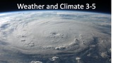
This elementary storyline developed for remote and hybrid teaching was made available …
This elementary storyline developed for remote and hybrid teaching was made available through the Growing Elementary Science Project a part of the Washington State ClimeTime initiative. This storyline is developed for 3-5 grade students and presents a weather phenomena in the form of a annual precipitation map from Washington State. Students analyze and interprete the graphical representation and ask questions about the difference between weather and climate. The storyline builds interest and student engagement through an interesting phenomena and then supprorts investigation to consider what is weather and what is climate.
In this resource, students watch a 2-minute video explaining albedo. The video …
In this resource, students watch a 2-minute video explaining albedo. The video shows visualizations of albedo across Earth and how it can change. Students will interpret the images in the video and answer questions about albedo.
No restrictions on your remixing, redistributing, or making derivative works. Give credit to the author, as required.
Your remixing, redistributing, or making derivatives works comes with some restrictions, including how it is shared.
Your redistributing comes with some restrictions. Do not remix or make derivative works.
Most restrictive license type. Prohibits most uses, sharing, and any changes.
Copyrighted materials, available under Fair Use and the TEACH Act for US-based educators, or other custom arrangements. Go to the resource provider to see their individual restrictions.