This screencast will show you how to use Google Earth Pro to …
This screencast will show you how to use Google Earth Pro to import freely available TIGER/Line shapefiles from the US Census Bureau. You can then use these shapefiles to build your own custom school boundary maps.
This activity uses Google Earth to explore the distribution of plate boundaries …
This activity uses Google Earth to explore the distribution of plate boundaries and hotspot volcanoes on Earth. It uses the ages and locations of the hotspot volcanoes to determine the direction and rate of plate motion.
Geographic information systems (GIS), once used predominantly by experts in cartography and …
Geographic information systems (GIS), once used predominantly by experts in cartography and computer programming, have become pervasive in everyday business and consumer use. This unit explores GIS in general as a technology about which much more can be learned, and it also explores applications of that technology. Students experience GIS technology through the use of Google Earth on the environmental topic of plastics in the ocean in an area known as the Great Pacific Garbage Patch. The use of this topic in GIS makes the unit multidisciplinary, incorporating the physics of ocean currents, the chemistry associated with pollutant degradation and chemical sorption to organic-rich plastics, and ecological impact to aquatic biota.
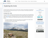
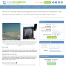
This activity introduces students to the Arctic and Arctic climate. Through a …
This activity introduces students to the Arctic and Arctic climate. Through a virtual exploration of the geography of the Arctic students become familiar with the region. They are then introduced to meteorological parameters that Arctic research teams use.
Students choose a place that is named based on its relationship to …
Students choose a place that is named based on its relationship to geomorphology. They research and describe the geologic template, geologic processes and time involved in the formation of their chosen place and use Google Earth to report their results.
This activity from a Geomorphology course is designed to familiiarize students with …
This activity from a Geomorphology course is designed to familiiarize students with using Google Earth, as well as making the connection between features they see in a map or satellite view vs. what they might see from ground level. Students will use this exercise as the first of several where they will evaluate landforms and the materials and processes responsible for their development.
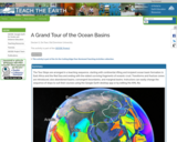
The Tour Stops are arranged in a teaching sequence, starting with continental …
The Tour Stops are arranged in a teaching sequence, starting with continental rifting and incipient ocean basin formation in East Africa and the Red Sea and ending with the oldest surviving fragments of oceanic crust. Transforms and fracture zones are introduced, also abandoned basins, convergent boundaries, and marginal basins. Instructors can easily change the sequence of stops to suit their courses using the Google Earth desktop app or by editing the KML file.
This activity introduces students to using Google Earth and adding layers to …
This activity introduces students to using Google Earth and adding layers to google earth, while re-enforcing plate tectonic concepts and evidence for plate tectonics. Outcomes: 1. Download Google Earth onto computer 2. Turn on/off layers within Google Earth 3. Be able to change measurement and use ruler within Google Earth 4. Determine latitude and longitude of ocean basin features 5. Be able to search for locations within Google Earth 6. Learn to upload new layers into Google Earth from .kmz files 7. Describe different plate boundaries, their locations and boundary interactions 8. Explain evidence for Plate Tectonics
User-friendly Geographic Information Systems (GIS) is the common thread of this collection …
User-friendly Geographic Information Systems (GIS) is the common thread of this collection of presentations, and activities with full lesson plans. The first section of the site contains an overview of cartography, the art of creating maps, and then looks at historical mapping platforms like Hypercities and Donald Rumsey Historical Mapping Project. In the next section Google Earth Desktop Pro is introduced, with lessons and activities on the basics of GE such as pins, paths, and kml files, as well as a more complex activity on "georeferencing" an historic map over Google Earth imagery. The final section deals with ARCGIS Online and StoryMaps with tutorials, basic exercises on pins, paths, and CSV import, and a lesson plan for creating a research project presentation on an historic building in StoryMaps. In addition to an xml file that has been uploaded here to Academic Works, the module is also a live website at https://libguides.brooklyn.cuny.edu/cs-x. The site was created with Libguides software, and is a Community Libguide that can be reused and imported into other LibGuides sites. The website also contains links to two live StoryMaps, one on an Introduction to ARCGIS StoryMaps (https://arcg.is/1SX1zH), and the second, a model assignment on the history of the Fairway building in Red Hook, Brooklyn (https://arcg.is/1nbHP).
Using a digital elevation model, prehistoric drainage and modern drainage in google …
Using a digital elevation model, prehistoric drainage and modern drainage in google earth, students will locate abandoned valleys, interpret prehistoric drainage orientations, measure and compare valley and channel widths of "new" sections of the Ohio River with tributary valleys which have been used by both prehistoric and modern rivers.
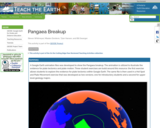
A Google Earth animation files was developed to show the Pangaea breakup. …
A Google Earth animation files was developed to show the Pangaea breakup. The animation is utilized to illustrate the evidence for plate tectonics and plate motion. Three student exercises are build around this resource: the first exercise allows students to explore the evidence for plate tectonics within Google Earth. The same file is then used in a Hot Spot and Plate Movement exercise that was developed as two versions, one for introductory students and a second for upper level geology majors.
Real World Math is a collection of free math activities for Google …
Real World Math is a collection of free math activities for Google Earth designed for students and educators. Mathematics is much more than a set of problems in a textbook. In the virtual world of Google Earth, concepts and challenges can be presented in a meaningful way that portray the usefulness of the ideas.
Reasons for the seasons (RFTS for short) is an interactive learning resource …
Reasons for the seasons (RFTS for short) is an interactive learning resource that leverages the popular Google Earth virtual globe. It is designed to help students and members of the public visualize and understand the multiple factors that influence Earth's seasons.
Cryptids, creatures of questionable existence, are used as a source of data …
Cryptids, creatures of questionable existence, are used as a source of data to guide students into the creation of their own GIS data layer in Google Earth. The activity serves the purpose of a tutorial to teach students how to make data layers with a simple subject. Then they use that skill on other topics such as plastics in their neighborhood.
Students overlay USGS topographic maps into Google Earth’s satellite imagery. By analyzing …
Students overlay USGS topographic maps into Google Earth’s satellite imagery. By analyzing Denali, a mountain in Alaska, they discover how to use map scales as ratios to navigate maps, and use rates to make sense of contour lines and elevation changes in an integrated GIS software program. Students also problem solve to find potential pathways up a mountain by calculating gradients.
Volcano shape is strongly controlled by eruptive style, which in turn is …
Volcano shape is strongly controlled by eruptive style, which in turn is controlled by magma composition and tectonic setting. This lab utilizes Google Earth, which takes students on a virtual field trip, in order to give them the opportunity to examine volcanoes from around the globe, and to interpret the tectonic settings in which they form. After completing this activity students will be able to describe and identify the common volcano types, and relate volcano types with associated volcanic hazards, tectonic setting, and geographic location.
In this six-lesson unit, students will explore stories from people who have …
In this six-lesson unit, students will explore stories from people who have migrated to Europe or North America from different countries in Africa in order to analyze the following essential questions:
Students complete a self-guided exercise in worksheet format combined with Google Earth …
Students complete a self-guided exercise in worksheet format combined with Google Earth that helps them explore practical and observable differences between different projection and coordinate systems. The activity improves their skills in using various Google Earth features.
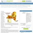
In a student-led and fairly independent fashion, data collected in the associated …
In a student-led and fairly independent fashion, data collected in the associated field trip activity are organized by student groups to create useful and informative Google Earth maps. Each team creates a map, uses that map to analyze the results, adjusts the map to include the analysis results, and then writes a brief summary of findings. Primarily, questions of fate-and-transport of plastics are are explored. If data was gathered in the field trip but the teacher does not desire to do the mapping activity, then alternative data presentation and analysis methods are suggested.
No restrictions on your remixing, redistributing, or making derivative works. Give credit to the author, as required.
Your remixing, redistributing, or making derivatives works comes with some restrictions, including how it is shared.
Your redistributing comes with some restrictions. Do not remix or make derivative works.
Most restrictive license type. Prohibits most uses, sharing, and any changes.
Copyrighted materials, available under Fair Use and the TEACH Act for US-based educators, or other custom arrangements. Go to the resource provider to see their individual restrictions.