In this activity, students use authentic Arctic climate data to explore albedo …
In this activity, students use authentic Arctic climate data to explore albedo and its relationship to seasonal snowmelt as a self-reinforcing feedback mechanism, which is then applied to large scale global climate change.
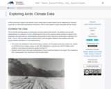
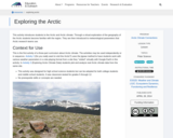
This activity introduces students to the Arctic and Arctic climate. Through a …
This activity introduces students to the Arctic and Arctic climate. Through a virtual exploration of the geography of the Arctic students become familiar with the region. They are then introduced to meteorological parameters that Arctic research teams use.
This lesson is a presentation of famous scientist throughout history where the …
This lesson is a presentation of famous scientist throughout history where the students will learn and take notes about the contributions and discoveries made in science.
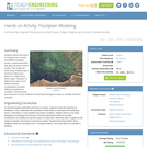
Students explore the impact of changing river volumes and different floodplain terrain …
Students explore the impact of changing river volumes and different floodplain terrain in experimental trials with table top-sized riverbed models. The models are made using modeling clay in aluminum baking pans placed on a slight incline. Water added "upstream" at different flow rates and to different riverbed configurations simulates different potential flood conditions. Students study flood dynamics as they modify the riverbed with blockages or levees to simulate real-world scenarios.
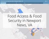
The series of maps presented here accompany a mixed-method, collaborative, and community-based …
The series of maps presented here accompany a mixed-method, collaborative, and community-based research project conducted as a part of a field research course in the Department of Sociology, Social Work, and Anthropology at Christopher Newport University.
The project focused on food access and its implications for food security and food justice in Newport News’ Southeast Community, a neighborhood marked by high levels of food insecurity and decades of racial segregation and economic divestment. The U.S. Department of Agriculture defines the Southeast Community of Newport News as a food desert, meaning that census tracts in this part of the city have higher than normal rates of poverty and include many areas that are more than 1-km walking distance from a grocery store or other source of competitively priced, nutritious food.
PhysicalGeography.net is an educational web portal that focuses on a specific area …
PhysicalGeography.net is an educational web portal that focuses on a specific area knowledge known as Physical Geography. Physical Geography is a sub-discipline of two much larger fields of study - Geography and Earth Sciences.
The discipline of Geography focuses on the science of place and space; …
The discipline of Geography focuses on the science of place and space; on how humans and the environment interact and influence each other. Our world is not flat and even though the problems we face seem global, each place on earth is experiencing them unevenly because of its location, resources, culture, and history. This course will help students to understand how most of the contemporary global challenges date back to colonialism and how complex our problems are and display spatial variability. Several global issues, such as migration, security, food, health, energy, and climate are the major topics to study the increasing global interconnectedness and socio ecological impacts of political, economic, and cultural globalization.
In this course students will: Demonstrate an ability to think globally and use geographic perspectives to analyze global phenomena. Critique various economic and political systems with regards to government influence in trade, development , environmental impacts, and social welfare. Evaluate their own lives and their connection to other cultures, places, and peoples in the world.
Course Description:GEO 212. Introduction to Meteorology (4 credit hour). Physical and chemical …
Course Description:GEO 212. Introduction to Meteorology (4 credit hour). Physical and chemical conditions that regulate global weather phenomena. Includes structure of the atmosphere, temperature, humidity, air pressure and winds, the development of weather systems, tornadoes and hurricanes, and the parameters that affect local and global climate. Laboratory includes image interpretation, field observation and prediction. This is formatted as an 8 week/module course.Learning Outcomes:1. Describe the origin and structure of the earth and its atmosphere. (1, 7)2. Use scientific reasoning to explain the relationship between the earth and sun and how solarand terrestrial radiation affects temperature, air pressure and wind patterns. (1, 2, 7, 8)3. Explain the role of heat, moisture and winds in generating clouds, precipitation and severeweather. (2-6, 8)4. Model major atmospheric circulation systems and oscillations. (1-8)5. Describe climatic regions and assess climate change predictions. (1-8)6. Interpret meteorological data to predict weather conditions. (1-8)
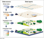
A geographic information system (GIS) is a computer system for capturing, storing, …
A geographic information system (GIS) is a computer system for capturing, storing, checking, and displaying data related to positions on Earth’s surface.
Focusing on air, water, land and life, this video describes how these …
Focusing on air, water, land and life, this video describes how these components are connected in the Earth system through the flow of energy, cycles of water and biogeochemistry. Methods of studying the Earth system, ranging from field observations to analysis of satellite images are discussed. This video is one of the 24-part instructional video series describing scientific protocols used by GLOBE (Global Learning and Observation to Benefit the Environment), a worldwide, hands-on, K-12 school-based science education program.
This video highlights students taking scientific measurements to support investigations in atmospheric …
This video highlights students taking scientific measurements to support investigations in atmospheric science, hydrology, soils, and land cover. It shows students reporting data through the Web, creating scientific visualizations for analysis, and collaborating with students and scientists around the world. This is one two introductory videos in the 24-part GLOBE video series. GLOBE (Global Learning and Observation to Benefit the Environment) is a worldwide, hands-on, K-12 school-based science education program.
This video highlights students taking scientific measurements to support investigations in atmospheric …
This video highlights students taking scientific measurements to support investigations in atmospheric science, hydrology, soils, and land cover. It shows students reporting data through the Web, creating scientific visualizations for analysis, and collaborating with students and scientists around the world. This is one of two introductory videos in the 24-part GLOBE video series. GLOBE (Global Learning and Observation to Benefit the Environment) is a worldwide, hands-on, K-12 school-based science education program.
This video demonstrates students locating and preparing a study site where they …
This video demonstrates students locating and preparing a study site where they can conduct field observations. The procedure used when describing a soil profile is outlined. The properties of soil are described, including the structure, color, consistence, and texture, as well as the presence of roots, rocks and free carbonates. Safety precautions are stressed. The resource includes a video and a written transcript, and is supported by the Soil Characterization, Field Measurement Protocol in the GLOBE Teacher Guide. This is one of five videos about soils in the 24-part instructional video series describing scientific protocols used by GLOBE (Global Learning and Observation to Benefit the Environment) a worldwide, hands-on, K-12 school-based science education program.
This video describes how to select a soil infiltration study site, and …
This video describes how to select a soil infiltration study site, and demonstrates procedures used when taking soil infiltration in the field. Instructions for fabricating a necessary piece of field equipment, a dual-ring soil infiltrometer, are provided. The resource includes a video and a written transcript, and is supported by the Soil Infiltration Protocol in the GLOBE Teacher's Guide. This is one of five videos about soils in the 24-part instructional video series describing scientific protocols used by GLOBE (Global Learning and Observation to Benefit the Environment) a worldwide, hands-on, K-12 school-based science education program.
This video describes how to select a soil moisture study site and …
This video describes how to select a soil moisture study site and sampling strategy, and identifies what laboratory instruments will be needed to complete a soil moisture analysis. Students are shown collecting soil moisture data and asking questions about what soil moisture data might tell them about the environment. The resource includes a video and a written transcript, and is supported by the Soil Moisture Protocol in the GLOBE Teacher's Guide. This is one of five videos about soils in the 24-part instructional video series describing scientific protocols used by GLOBE (Global Learning and Observation to Benefit the Environment), a worldwide, hands-on, K-12 school-based science education program.
The Geographic Alliance of Iowa (GAI) was established in 1991 with the …
The Geographic Alliance of Iowa (GAI) was established in 1991 with the support of the National Geographic Society (NGS). GAI is composed of K-12 teachers, college and university professors, personnel from a variety of other educational endeavors, and citizens, all of who are concerned with improving geographic instruction in Iowa. As the only entity in Iowa specifically devoted to geography education, the mission of the Geographic Alliance of Iowa (GAI) is to help ensure K-12 graduates are geographically literate citizens. To achieve this mission, the GAI provides resources and expertise to improve the geographic literacy of Iowa students. With a particular focus on K-12 education, including pre-service teachers, the GAI provides exemplary professional development opportunities that follow accepted best practices and offers a clearinghouse of accessible, high quality, standards-based curricular materials.
Learn how to read and interpret maps and data and use basic …
Learn how to read and interpret maps and data and use basic cartography principles to create maps that can be used in reports and presentations. After learning basic concepts, attendees will work through an exercise using ArcGIS Pro or QGIS.
No restrictions on your remixing, redistributing, or making derivative works. Give credit to the author, as required.
Your remixing, redistributing, or making derivatives works comes with some restrictions, including how it is shared.
Your redistributing comes with some restrictions. Do not remix or make derivative works.
Most restrictive license type. Prohibits most uses, sharing, and any changes.
Copyrighted materials, available under Fair Use and the TEACH Act for US-based educators, or other custom arrangements. Go to the resource provider to see their individual restrictions.