This exercise looks at the dollar losses and deaths caused by flooding …
This exercise looks at the dollar losses and deaths caused by flooding in the US, and at the causes of, and relationships between the two trends.
(Note: this resource was added to OER Commons as part of a batch upload of over 2,200 records. If you notice an issue with the quality of the metadata, please let us know by using the 'report' button and we will flag it for consideration.)
This is the data collection portion of a semester-long project. Before this …
This is the data collection portion of a semester-long project. Before this lab, students will have graphed discharge data for one previous water year, graphed similar data collected by classes during a previous year, written one-page explanations of the techniques that they will be using, and speculated about the results they expect to get. After this lab, their data will be shared with other lab sections, which will have collected similar data at other sites along the same river. Each research group will present their preliminary data to the class during a later lab meeting, and the class will discuss how the different types of data relate to one another. The project culminates in a final paper (one per research group).
(Note: this resource was added to OER Commons as part of a batch upload of over 2,200 records. If you notice an issue with the quality of the metadata, please let us know by using the 'report' button and we will flag it for consideration.)
This is a homework assignment used as preparation for a group research …
This is a homework assignment used as preparation for a group research project. Students graph annual discharge data from a local river by hand, and compare the discharge patterns from the stream above a reservoir with those below the dam. This exercise gives students practice graphing a small amount of data by hand, and gets them thinking about ways graphs can be used to help interpret data.
(Note: this resource was added to OER Commons as part of a batch upload of over 2,200 records. If you notice an issue with the quality of the metadata, please let us know by using the 'report' button and we will flag it for consideration.)
This group research project serves as the focus for our introductory Earth …
This group research project serves as the focus for our introductory Earth Systems Science classes. Each of four to six lab sections of 15-25 students collect discharge, sediment load, and water chemistry data from a different site along a local river, and compare their data to that collected in previous years and at other sites along the river. The project incorporates topographic map reading and graphing as well as collecting and analyzing data, and presenting the results in oral and written form. Labs on rocks and minerals use samples from the project area to encourage students to make connections between the solid Earth and surface processes.
Each component of the Florida River Project is described below, with a link to the activity sheet and related files.
Topographic Maps: Integrated Florida River project Florida River Project: Minerals in the field Florida River Project: Sedimentary and metamorphic rocks lab Florida River Project: Plotting discharge data Plotting Florida River Data Using Excel Florida River Project: Measuring discharge, sediment, and water chemistry
(Note: this resource was added to OER Commons as part of a batch upload of over 2,200 records. If you notice an issue with the quality of the metadata, please let us know by using the 'report' button and we will flag it for consideration.)
The Florida River Project is a semester-long project involving (1) an individual …
The Florida River Project is a semester-long project involving (1) an individual project in which students pose a scientific question and use existing data to test their hypothesis, and (2) a group project in which students collect and present data associated with stream monitoring.
Outcomes of the individual project include: - Practice applying the process of science - Graphing and interpreting data - Making an argument supported by quantitative evidence. - Communicating a scientific argument in writing. - Supporting a scientific argument using appropriate formats (especially graphs and tables)
Outcomes of the group project include: - Collecting field data (discharge, sediment load, water chemistry) - Presenting data orally. - Discussing preliminary interpretations of data.
(Note: this resource was added to OER Commons as part of a batch upload of over 2,200 records. If you notice an issue with the quality of the metadata, please let us know by using the 'report' button and we will flag it for consideration.)
The lab starts with a short lecture on the scientific method, after …
The lab starts with a short lecture on the scientific method, after which students observe the results of a flume run that includes skeletal clasts. They form hypotheses about how bone clasts (or any clast for that matter) move and are deposited by a flow, then the students test their hypotheses by running a flume trial. The hypothesis tests take place in small groups (3-5 students), and the lab ends with homework where students use the information they learned from their hypothesis tests to interpret a fossil assemblage. As such, this is a wonderful activity for introductory geology classes, could be used effectively with minor adjustments for advanced paleontology, taphonomy, and forensic physical anthropology classes.
Short Description: Drawing upon the food security literature and current events in …
Short Description: Drawing upon the food security literature and current events in the media, this survey course will encourage learners to build a new understanding of food security, water shortages in agricultural production, and climate change challenges in agriculture. We will introduce policy tools and case studies illustrating the effects that climate change has on agriculture which will be useful and applicable to individual cross-disciplinary learning.
Long Description: Food security is one of the most pressing dilemmas of our time. Around the globe, approximately 2 billion people experience some form of food deprivation each day. One in ten people suffer from some form of food insecurity in Canada. This has led scholars to question why food insecurity exists in an ostensibly food secure country. The literature on food security and climate change has also grown exponentially over the past several decades in large part as a response to world events such as the Green Revolution and other forms of industrial agricultural development since the 1970s. Despite the advances in research and technology, we still possess inadequate knowledge of the dynamics causing the onset of food insecurity, and significant disagreement persists among scholars concerning the best way to ameliorate food insecurity.
Drawing upon the food security literature and current events in the media, this survey course will encourage learners to build a new understanding of food security, water shortages in agricultural production, and climate change challenges in agriculture. We will introduce policy tools and case studies illustrating the effects that climate change has on agriculture which will be useful and applicable to individual cross-disciplinary learning.
This course is part of the Adaptation Learning Network led by the Resilience by Design Lab at Royal Roads University. The project is supported by the Climate Action Secretariat of the BC Ministry of Environment & Climate Change Strategy and Natural Resources Canada through its Building Regional Adaptation Capacity and Expertise (BRACE) program. The BRACE program works with Canadian provinces to support training activities that help build skills and expertise on climate adaptation and resilience.
Word Count: 19025
(Note: This resource's metadata has been created automatically by reformatting and/or combining the information that the author initially provided as part of a bulk import process.)
This is one component of the Source to Sink Mini Lesson Set …
This is one component of the Source to Sink Mini Lesson Set Continental margins are phenomenal places to study the modern sedimentary cycle because sediment in margin regions has been routed from mountains (source) through river systems to the sea (sink); in some cases, sediment has continued across continental shelves and been delivered to the deep sea. The goal of this mini-lesson is to let students explore the characteristics of some key regions in the modern sedimentary cycle to identify and relate the variables that control source-to-sink systems. Which areas are eroding most rapidly and why? Which systems are responsible for the most rapid transfer of sediments from continents to the oceans? How do the characteristics of river systems affect the properties of the sediments they discharge? How can we apply our knowledge of these modern source-to-sink systems to the ancient sedimentary rock record?
Word Count: 30350 (Note: This resource's metadata has been created automatically by …
Word Count: 30350
(Note: This resource's metadata has been created automatically by reformatting and/or combining the information that the author initially provided as part of a bulk import process.)
This project is used instead of a final exam in an upper …
This project is used instead of a final exam in an upper level undergraduate course in Applied GIS. A student may propose their own project, or choose one from a list from the instructor. A brief proposal must be approved by the instructor before the project can begin. Students will construct a working, query-able database, use appropriate imagery, and use it to analyze a problem, understand cause and effect, and show changes with time. A final report must be submitted with all supporting documentation in digital form. Students also give a PP presentation in one of the last class meetings.
(Note: this resource was added to OER Commons as part of a batch upload of over 2,200 records. If you notice an issue with the quality of the metadata, please let us know by using the 'report' button and we will flag it for consideration.)
Students work with data bases and GIS to develop saturated thickness maps. …
Students work with data bases and GIS to develop saturated thickness maps. Each data base consists of observations made by drillers where they have encountered the High Plains aquifer base and the annual water-level measurements taken in wells screened in the High Plains aquifer by field technicians.
(Note: this resource was added to OER Commons as part of a batch upload of over 2,200 records. If you notice an issue with the quality of the metadata, please let us know by using the 'report' button and we will flag it for consideration.)
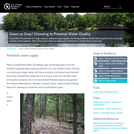
This exercise posits a hypothetical situation: you would like to purchase land …
This exercise posits a hypothetical situation: you would like to purchase land that will provide your family with opportunities to fish and swim in a stream on your property. Additionally, you would like the land to afford some privacy. In order to find such a place, you need to locate land for sale that has a stream running through it and you want to confirm that the stream water is clean. The following activity illustrates how one can locate land with particular characteristics and also assess surface water quality for local bodies of water. The data you will use might pertain to any location where streams flow through residential areas.
(Note: this resource was added to OER Commons as part of a batch upload of over 2,200 records. If you notice an issue with the quality of the metadata, please let us know by using the 'report' button and we will flag it for consideration.)
Geography 431 is designed to further understanding of the natural processes of …
Geography 431 is designed to further understanding of the natural processes of aquatic ecosystems, management of water resources, and threats to sustaining water quantity. Develop awareness and appreciation of the perspectives about water as a precious resource, commodity, and sometimes hazard. Learn how and why water is distributed unevenly around the Earth. Examine how resource management decisions are strongly related to water availability, quantity, and quality. The course examines water resources management; dams and dam removal; provision of safe potable water; threats to water quantity and quality; land use changes; the water economy; water laws and policy; institutions for water management at the global, national, regional, and local scale; and issues of water security and climate change.
This two-week long laboratory exercise examines the linkages between the endogenic (tectonic …
This two-week long laboratory exercise examines the linkages between the endogenic (tectonic and isostatic) and exogenic processes that created the Eastern Snake River Plain (ESRP) landscape. The landform analysis portion of the exercise focuses upon recent basaltic volcanism and the Menan Buttes, the St. Anthony dunes and the fluvial drainage patterns that developed in the region.
This exercise takes advantage of student's interest in Google Earth to teach …
This exercise takes advantage of student's interest in Google Earth to teach some basic concepts about meandering rivers. Students prepare for class by reading about lowland rivers and/or hearing a lecture on them. They bring their own laptops to class or share with a partner or I take the entire class to the computer lab next door. In class they work through the worksheet and use Google Earth to take quantitative measurements of the rivers. They look at historic migration of meander bends and quantify river sinuousity, wavelength, amplitude, and radius of curvature of meander bends. They explore meandering bedrock rivers in Taiwan as a cool thought exercise in how that can happen. They end with looking at images from an area that they will have a field trip to during their next lab period. To keep people from flying through the exercise and getting bored, we do the whole activity in think-pair-share style. Students work on a location, answer the questions, and then we discuss it as a class.
(Note: this resource was added to OER Commons as part of a batch upload of over 2,200 records. If you notice an issue with the quality of the metadata, please let us know by using the 'report' button and we will flag it for consideration.)
This course introduces students to basic rain garden design, water cistern development, …
This course introduces students to basic rain garden design, water cistern development, and bioretention principles. Students will also explore the uses of landform, plants, and structure to shape space. Classes will include slide-illustrated lectures, class discussions, and project critiques. Through a combination of short practicum that includes rain garden design for residential, commercial, and government locations, students will be able to analyze and create a design that applies modern theories to questions of spatial organization, order, and selection of building materials. Students will translate research and case studies by applying building, drawing, and design critiques specific for the site design and present their findings to the community.
(Note: this resource was added to OER Commons as part of a batch upload of over 2,200 records. If you notice an issue with the quality of the metadata, please let us know by using the 'report' button and we will flag it for consideration.)
Faced with the potential of a large expense related to water quality, …
Faced with the potential of a large expense related to water quality, the Portland (Maine) Water District performed a thorough analysis of their options. Their choice came down to making an investment in conservation or concrete.
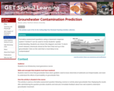
Formative assessment questions using a classroom response system ("clickers") can be used …
Formative assessment questions using a classroom response system ("clickers") can be used to reveal students' spatial understanding. Students are shown this diagram and told, "A storm event releases chemicals stored at the farm that end up in the groundwater. Click on the well that is most likely to be contaminated."
(Note: this resource was added to OER Commons as part of a batch upload of over 2,200 records. If you notice an issue with the quality of the metadata, please let us know by using the 'report' button and we will flag it for consideration.)
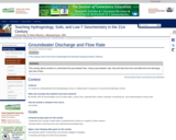
This activity allows students to understand the groundwater flow. Using a groundwater …
This activity allows students to understand the groundwater flow. Using a groundwater map, they will draw flow lines and determine the discharge and rate of flow.
(Note: this resource was added to OER Commons as part of a batch upload of over 2,200 records. If you notice an issue with the quality of the metadata, please let us know by using the 'report' button and we will flag it for consideration.)
Students will work in groups to make observations, identify aquifers, describe aquifer …
Students will work in groups to make observations, identify aquifers, describe aquifer properties and measure hydraulic head in a physical groundwater flow model. The information collected will be used to answer questions pertaining to the groundwater flow system. The activity serves to consolidate the key concepts covered in lecture materials. These concepts include the water cycle, hydraulic head, types of aquifers, hydraulic conductivity, permeability, Darcy's Law, hydraulic gradient, porosity and groundwater contamination.
(Note: this resource was added to OER Commons as part of a batch upload of over 2,200 records. If you notice an issue with the quality of the metadata, please let us know by using the 'report' button and we will flag it for consideration.)
No restrictions on your remixing, redistributing, or making derivative works. Give credit to the author, as required.
Your remixing, redistributing, or making derivatives works comes with some restrictions, including how it is shared.
Your redistributing comes with some restrictions. Do not remix or make derivative works.
Most restrictive license type. Prohibits most uses, sharing, and any changes.
Copyrighted materials, available under Fair Use and the TEACH Act for US-based educators, or other custom arrangements. Go to the resource provider to see their individual restrictions.