This course's aims are two-fold: to offer students the theoretical and practical …
This course's aims are two-fold:
to offer students the theoretical and practical tools to understand how and why cities become torn by ethnic, religious, racial, nationalist, and/or other forms of identity that end up leading to conflict, violence, inequality, and social injustice; and to use this knowledge and insight in the search for solutions
As preparation, students will be required to become familiar with social and political theories of the city and the nation and their relationship to each other. They also will focus on the ways that racial, ethnic, religious, nationalist or other identities grow and manifest themselves in cities or other territorial levels of determination (including the regional or transnational). In the search for remedies, students will be encouraged to consider a variety of policymaking or design points of entry, ranging from the political- institutional (e.g. forms of democratic participation and citizenship) to spatial, infrastructural, and technological interventions.
This course is designed to provide an understanding of how the human …
This course is designed to provide an understanding of how the human brain works in health and disease, and is intended for both the Brain and Cognitive Sciences major and the non-Brain and Cognitive Sciences major. Knowledge of how the human brain works is important for all citizens, and the lessons to be learned have enormous implications for public policy makers and educators. The course will cover the regional anatomy of the brain and provide an introduction to the cellular function of neurons, synapses and neurotransmitters. Commonly used drugs that alter brain function can be understood through a knowledge of neurotransmitters. Along similar lines, common diseases that illustrate normal brain function will be discussed. Experimental animal studies that reveal how the brain works will be reviewed. Throughout the seminar we will discuss clinical cases from Dr. Byrne's experience that illustrate brain function; in addition, articles from the scientific literature will be discussed in each class.
•Understand what metadata is and how it relates to DCAT• Learn about …
•Understand what metadata is and how it relates to DCAT• Learn about the history and objectives of DCAT• Understand the basic model of DCAT• See some examples of DCAT entities
•Understand what Metadata is and how it relates to DCAT• Learn about …
•Understand what Metadata is and how it relates to DCAT• Learn about the history and objectives of DCAT• Understand the basic Model of DCAT• See some examples of DCAT Entities• See some examples of DCAT Spatial & Temporal Properties
This book is about using the power of computers to do things …
This book is about using the power of computers to do things with geographic data. It teaches a range of spatial skills, including: reading, writing and manipulating geographic data; making static and interactive maps; applying geocomputation to solve real-world problems; and modeling geographic phenomena. By demonstrating how various geographic operations can be linked, in reproducible ‘code chunks’ that intersperse the prose, the book also teaches a transparent and thus scientific workflow. Learning how to use the wealth of geospatial tools available from the R command line can be exciting, but creating new ones can be truly liberating. Using the command-line driven approach taught throughout, and programming techniques covered in Chapter 11, can help remove constraints on your creativity imposed by software. After reading the book and completing the exercises, you should therefore feel empowered with a strong understanding of the possibilities opened up by R’s impressive geographic capabilities, new skills to solve real-world problems with geographic data, and the ability to communicate your work with maps and reproducible code.
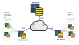
Data Carpentry lesson to understand data structures and common storage and transfer …
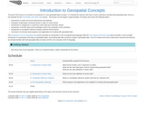
Data Carpentry lesson to understand data structures and common storage and transfer formats for spatial data. The goal of this lesson is to provide an introduction to core geospatial data concepts. It is intended for learners who have no prior experience working with geospatial data, and as a pre-requisite for the R for Raster and Vector Data lesson . This lesson can be taught in approximately 75 minutes and covers the following topics: Introduction to raster and vector data format and attributes Examples of data types commonly stored in raster vs vector format Introduction to categorical vs continuous raster data and multi-layer rasters Introduction to the file types and R packages used in the remainder of this workshop Introduction to coordinate reference systems and the PROJ4 format Overview of commonly used programs and applications for working with geospatial data The Introduction to R for Geospatial Data lesson provides an introduction to the R programming language while the R for Raster and Vector Data lesson provides a more in-depth introduction to visualization (focusing on geospatial data), and working with data structures unique to geospatial data. The R for Raster and Vector Data lesson assumes that learners are already familiar with both geospatial data concepts and the core concepts of the R language.
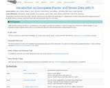
Data Carpentry lesson to open, work with, and plot vector and raster-format …
Data Carpentry lesson to open, work with, and plot vector and raster-format spatial data in R. The episodes in this lesson cover how to open, work with, and plot vector and raster-format spatial data in R. Additional topics include working with spatial metadata (extent and coordinate reference systems), reprojecting spatial data, and working with raster time series data.
The past decade has seen an explosion of new mechanisms for understanding …
The past decade has seen an explosion of new mechanisms for understanding and using location information in widely-accessible technologies. This Geospatial Revolution has resulted in the development of consumer GPS tools, interactive web maps, and location-aware mobile devices. This course brings together core concepts in cartography, geographic information systems, and spatial thinking with real-world examples to provide the fundamentals necessary to engage with Geographic Information Science. We explore what makes spatial information special, how spatial data is created, how spatial analysis is conducted, and how to design maps so that they're effective at telling the stories we wish to share. To gain experience using this knowledge, we work with the latest mapping and analysis software to explore geographic problems.
The goal of this lecture plan "Spatial data analyzing" is to adapt the …
The goal of this lecture plan "Spatial data analyzing" is to adapt the final project of Edit-027, at this time, this document helps students acquire technical skills in using GIS opensource software (QGIS) for producing, managing databases, and to develop research skills in spatial analysis.This module is for 0.5 credit hoursThis OER document was adapted from OER "Introduction to GIS for urban studies"
No restrictions on your remixing, redistributing, or making derivative works. Give credit to the author, as required.
Your remixing, redistributing, or making derivatives works comes with some restrictions, including how it is shared.
Your redistributing comes with some restrictions. Do not remix or make derivative works.
Most restrictive license type. Prohibits most uses, sharing, and any changes.
Copyrighted materials, available under Fair Use and the TEACH Act for US-based educators, or other custom arrangements. Go to the resource provider to see their individual restrictions.