DATA: Planetary images and geodesy data. TOOL: UNAVCO's Jules Verne Voyager Map Server. SUMMARY: Generate maps of Earth or any of 19 other planets and moons. Save and import images into presentations or reports.
(Note: this resource was added to OER Commons as part of a batch upload of over 2,200 records. If you notice an issue with the quality of the metadata, please let us know by using the 'report' button and we will flag it for consideration.)
DATA: Global Digital Elevation Model (DEM) TOOLS: GeoMapApp, Spreadsheet SUMMARY: Use GeoMapApp …
DATA: Global Digital Elevation Model (DEM) TOOLS: GeoMapApp, Spreadsheet SUMMARY: Use GeoMapApp to search for evidence of glacial expansion and retreat. Produce a research report of your findings modeled on peer-reviewed papers in the field of glaciology.
(Note: this resource was added to OER Commons as part of a batch upload of over 2,200 records. If you notice an issue with the quality of the metadata, please let us know by using the 'report' button and we will flag it for consideration.)
DATA: Sea Floor Age, Volcano and Earthquake Distributions. TOOL: My World GIS. …
DATA: Sea Floor Age, Volcano and Earthquake Distributions. TOOL: My World GIS. SUMMARY: Identify relationships among sea-floor age, earthquakes, and volcanoes to understand how they support the theory of plate tectonics.
(Note: this resource was added to OER Commons as part of a batch upload of over 2,200 records. If you notice an issue with the quality of the metadata, please let us know by using the 'report' button and we will flag it for consideration.)
DATA: NASA Aura nitrogen dioxide data. TOOL: Google Earth. SUMMARY: Learn about …
DATA: NASA Aura nitrogen dioxide data. TOOL: Google Earth. SUMMARY: Learn about photochemical smog. Explore the relationships among human population density, nitrogen dioxide concentrations, and geography.
(Note: this resource was added to OER Commons as part of a batch upload of over 2,200 records. If you notice an issue with the quality of the metadata, please let us know by using the 'report' button and we will flag it for consideration.)
DATA: Worldwide Wetlands Inventory. TOOL: Ramsar International Wetlands Data Gateway. SUMMARY: Learn …
DATA: Worldwide Wetlands Inventory. TOOL: Ramsar International Wetlands Data Gateway. SUMMARY: Learn about wetlands around the world. Perform a series of searches to identify wetland areas that need protection.
(Note: this resource was added to OER Commons as part of a batch upload of over 2,200 records. If you notice an issue with the quality of the metadata, please let us know by using the 'report' button and we will flag it for consideration.)
DATA: Precipitation, streamflow, and topographic data TOOLS: Google Earth & My World …
DATA: Precipitation, streamflow, and topographic data TOOLS: Google Earth & My World GIS SUMMARY: Explore a semi-arid watershed in Arizona. Investigate the effect of summer thunderstorms on streamflow.
(Note: this resource was added to OER Commons as part of a batch upload of over 2,200 records. If you notice an issue with the quality of the metadata, please let us know by using the 'report' button and we will flag it for consideration.)
DATA: Digital Elevation Model Data. TOOL: GeoMapApp. SUMMARY: Explore a timeline about …
DATA: Digital Elevation Model Data. TOOL: GeoMapApp. SUMMARY: Explore a timeline about how we have learned about the oceans. Construct a profile across the Atlantic Ocean and create 3-D visualizations of the seafloor.
(Note: this resource was added to OER Commons as part of a batch upload of over 2,200 records. If you notice an issue with the quality of the metadata, please let us know by using the 'report' button and we will flag it for consideration.)
DATA: GOES Weather Images. TOOL: ImageJ. SUMMARY: Transform a time series of …
DATA: GOES Weather Images. TOOL: ImageJ. SUMMARY: Transform a time series of GOES images into an animation. Plot a storm track and determine storm speed.
(Note: this resource was added to OER Commons as part of a batch upload of over 2,200 records. If you notice an issue with the quality of the metadata, please let us know by using the 'report' button and we will flag it for consideration.)
DATA: SHALDRIL Core Data; NOAA Pollen data TOOL: GeoMapApp SUMMARY: Import Antarctic sediment core data files into GeoMapApp to create maps and graphs. Use data to infer past climate conditions based on current vegetation distributions.
(Note: this resource was added to OER Commons as part of a batch upload of over 2,200 records. If you notice an issue with the quality of the metadata, please let us know by using the 'report' button and we will flag it for consideration.)
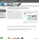
DATA: Recent and Historical Earthquake Data. TOOL: ArcExplorer Java Edition for Education …
DATA: Recent and Historical Earthquake Data. TOOL: ArcExplorer Java Edition for Education GIS. SUMMARY: Explore earthquake data and import them into a Geographic Information System (GIS). Analyze the data to predict where the next big earthquake will occur.
(Note: this resource was added to OER Commons as part of a batch upload of over 2,200 records. If you notice an issue with the quality of the metadata, please let us know by using the 'report' button and we will flag it for consideration.)
DATA: Seismic Wave Model Output. TOOLS: My World GIS, Microsoft Excel. SUMMARY: …
DATA: Seismic Wave Model Output. TOOLS: My World GIS, Microsoft Excel. SUMMARY: Examine seismic wave data in a Geographic Information System (GIS). Analyze wave velocities to infer the depth of the crust-mantle boundary.
(Note: this resource was added to OER Commons as part of a batch upload of over 2,200 records. If you notice an issue with the quality of the metadata, please let us know by using the 'report' button and we will flag it for consideration.)
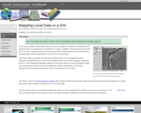
DATA: Student-collected GPS data and site characterizations TOOLS: MyWorld GIS, spreadsheet program …
DATA: Student-collected GPS data and site characterizations TOOLS: MyWorld GIS, spreadsheet program SUMMARY: Follow a study of Urban Heat Islands as an example of map-based science research projects.
(Note: this resource was added to OER Commons as part of a batch upload of over 2,200 records. If you notice an issue with the quality of the metadata, please let us know by using the 'report' button and we will flag it for consideration.)
DATA: MODIS Imagery. TOOL: ImageJ. SUMMARY: Examine images of the Aral Sea …
DATA: MODIS Imagery. TOOL: ImageJ. SUMMARY: Examine images of the Aral Sea from 1973 through 2003. Use image analysis software to measure changes in the width and area of the freshwater lake over time.
(Note: this resource was added to OER Commons as part of a batch upload of over 2,200 records. If you notice an issue with the quality of the metadata, please let us know by using the 'report' button and we will flag it for consideration.)
DATA: Forest Inventory Growth and Analysis data, TOOLS: Spreadsheet, My World GIS …
DATA: Forest Inventory Growth and Analysis data, TOOLS: Spreadsheet, My World GIS SUMMARY: Investigate forest biodiversity in Maine and consider the environmental factors that contribute to tree species diversity.
(Note: this resource was added to OER Commons as part of a batch upload of over 2,200 records. If you notice an issue with the quality of the metadata, please let us know by using the 'report' button and we will flag it for consideration.)
DATA: Forest Inventory and Analysis data, TOOLS: isee Player, Spreadsheet application. SUMMARY: Compare field collected data with results produced by a forest biomass model to understand the process and challenges scientists face when doing terrestrial carbon cycle research.
(Note: this resource was added to OER Commons as part of a batch upload of over 2,200 records. If you notice an issue with the quality of the metadata, please let us know by using the 'report' button and we will flag it for consideration.)
DATA: Ocean Buoy Data, MODIS Images TOOLS: GoMOOS Online Graphing Tool SUMMARY: Learn about conditions that influence the spring phytoplankton bloom. Use an online graphing tool to predict the date of the bloom.
(Note: this resource was added to OER Commons as part of a batch upload of over 2,200 records. If you notice an issue with the quality of the metadata, please let us know by using the 'report' button and we will flag it for consideration.)
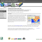
For this exercise we meet in a computer lab and students access …
For this exercise we meet in a computer lab and students access the IRIS Earthquake Browser to download geospatial information of earthquakes. Students use the GEON Integrated Data Viewer (IDV) to explore the location of earthquake zones and their 3-dimensional characteristics. Students compare the earthquake characteristics of subduction zones, mid-oceanic ridges, and transform faults. This leads into a discussion of plate tectonics.
(Note: this resource was added to OER Commons as part of a batch upload of over 2,200 records. If you notice an issue with the quality of the metadata, please let us know by using the 'report' button and we will flag it for consideration.)
In this activity students explore the Earth's radiation budget using Earth radiation …
In this activity students explore the Earth's radiation budget using Earth radiation Budget Experiment (ERBE) data archived at the IRI/LDEO Climate Data Library (more info) .
(Note: this resource was added to OER Commons as part of a batch upload of over 2,200 records. If you notice an issue with the quality of the metadata, please let us know by using the 'report' button and we will flag it for consideration.)
Economy is related with the money in the market which is been …
Economy is related with the money in the market which is been affected by the demand and supply of goods and services. Recent trend of GST has affected market the most
No restrictions on your remixing, redistributing, or making derivative works. Give credit to the author, as required.
Your remixing, redistributing, or making derivatives works comes with some restrictions, including how it is shared.
Your redistributing comes with some restrictions. Do not remix or make derivative works.
Most restrictive license type. Prohibits most uses, sharing, and any changes.
Copyrighted materials, available under Fair Use and the TEACH Act for US-based educators, or other custom arrangements. Go to the resource provider to see their individual restrictions.