Updating search results...

Search Resources

7512 Results

View
Selected filters:
  • Life Science
  • Conditional Remix & Share Permitted
1.1 Anat
Conditional Remix & Share Permitted
CC BY-NC
Rating
0.0 stars

In this resource we have explained the process of respiratory system including all the functions that are performed during the process of respiration. The role of each and every part involved in respiratory system is explained with proper diagrams as well.

Subject:
Life Science
Material Type:
Diagram/Illustration
Lecture Notes
Lesson
Reading
Date Added:
07/10/2018
1.1 Anatomia e Fisiologia do sistema respiratorio
Conditional Remix & Share Permitted
CC BY-NC
Rating
0.0 stars

In this resource we have explained the process of respiratory system including all the functions that are performed during the process of respiration. The role of each and every part involved in respiratory system is explained with proper diagrams as well.

Subject:
Life Science
Material Type:
Diagram/Illustration
Lecture Notes
Lesson
Reading
Date Added:
08/11/2018
1.1 Anatomy and Physiology of Respiratory System
Conditional Remix & Share Permitted
CC BY-NC
Rating
0.0 stars

In this resource we have explained the process of respiratory system including all the functions that are performed during the process of respiration. The role of each and every part involved in respiratory system is explained with proper diagrams as well.

Subject:
Life Science
Material Type:
Diagram/Illustration
Lecture Notes
Lesson
Reading
Date Added:
02/03/2018
1993 Missouri River Flood Exercise
Conditional Remix & Share Permitted
CC BY-NC-SA
Rating
0.0 stars

An exercise on the effects of flooding that took place in the upper Mississippi River drainage basin in 1993, using before and after satellite images.

(Note: this resource was added to OER Commons as part of a batch upload of over 2,200 records. If you notice an issue with the quality of the metadata, please let us know by using the 'report' button and we will flag it for consideration.)

Subject:
Biology
Geoscience
Life Science
Physical Science
Material Type:
Activity/Lab
Provider:
Science Education Resource Center (SERC) at Carleton College
Provider Set:
Teach the Earth
Author:
John Bartley
Date Added:
11/15/2016
1996 Grand Canyon Flood Analysis
Conditional Remix & Share Permitted
CC BY-NC-SA
Rating
0.0 stars

Analyze the effect of a 1996 controlled flood on a sandbar in Grand Canyon. This exercise uses Spatial Analyst and 3D Analyst.

(Note: this resource was added to OER Commons as part of a batch upload of over 2,200 records. If you notice an issue with the quality of the metadata, please let us know by using the 'report' button and we will flag it for consideration.)

Subject:
Biology
Life Science
Material Type:
Activity/Lab
Provider:
Science Education Resource Center (SERC) at Carleton College
Provider Set:
Teach the Earth
Author:
Mark Manone
Date Added:
08/17/2019
1. Hive Alive! Sweet Virginia Foundation: Bee Bodies Lesson
Conditional Remix & Share Permitted
CC BY-NC-SA
Rating
0.0 stars

Learn how important the honey bee's body structure is to survival in the hive. This lesson includes learning objectives, material and resource lists, background information, activities, reading selections, writing assignments, a game, assessments, and support documents. See the Educator's Guide for more video links and recommended readings. 

Subject:
Biology
Education
Elementary Education
Environmental Science
Environmental Studies
Life Science
Material Type:
Activity/Lab
Author:
Ken Harrison
Date Added:
03/21/2021
1. Hive Alive! Sweet Virginia Foundation: Bee Bodies Lesson
Conditional Remix & Share Permitted
CC BY-NC-SA
Rating
0.0 stars

Learn how important the honey bee's body structure is to survival in the hive. This lesson includes learning objectives, material and resource lists, background information, activities, reading selections, writing assignments, a game, assessments, and support documents. See the Educator's Guide for more video links and recommended readings. 

Subject:
Biology
Education
Elementary Education
Environmental Science
Environmental Studies
Life Science
Material Type:
Activity/Lab
Assessment
Game
Lesson Plan
Reading
Teaching/Learning Strategy
Author:
The Bee Cause Project
Date Added:
12/18/2020
2004 Asian Earthquake and Tsunami Disaster Project
Conditional Remix & Share Permitted
CC BY-NC-SA
Rating
0.0 stars

This is a problem-based learning (PBL) group jigsaw activity. The scenario is:
Students are employees of a unit of the United Nations responsible for coordinating disaster relief after a major disaster (the 2004 Asian Earthquake and Tsunami) occurs. The agency needs to understand the situation in each country so that it can coordinate the work of various governments and nongovernmental organizations (NGOs) working in the affected area.

Students are divided into Expert Groups (related to academic specialties such as Economics, Medicine, Political Science, Earth Science, etc.) and spend several days researching their topics. Students are then reassigned to one of seven or eight Country Groups, based on the countries most affected by the disaster. Each country group needs someone representing each expert group. In the scenario, these groups correspond to task forces that must determine what the situation is in each country and try to assess the current need for international assistance.

Students research their country, using internet resources, especially the CIA World Factbook and ReliefWeb, the information coordination website of the United Nations. At a large-group roundtable discussion, each group presents what it has found about its assigned country. As a final product, each student writes an individual report summarizing findings and making recommendations for disaster assistance.

(Note: this resource was added to OER Commons as part of a batch upload of over 2,200 records. If you notice an issue with the quality of the metadata, please let us know by using the 'report' button and we will flag it for consideration.)

Subject:
Biology
Life Science
Oceanography
Physical Science
Material Type:
Activity/Lab
Homework/Assignment
Provider:
Science Education Resource Center (SERC) at Carleton College
Provider Set:
Teach the Earth
Author:
Char Bezanson
Date Added:
08/30/2020
2004 Asian Earthquake and Tsunami Disaster Project
Conditional Remix & Share Permitted
CC BY-NC-SA
Rating
0.0 stars

Students are employees of a unit of the United Nations responsible for coordinating disaster relief after a major disaster (the 2004 Asian Earthquake and Tsunami) occurs. The agency needs to understand the situation in each country so that it can coordinate the work of various governments and NGO (nongovernmental organizations) working in the affected area.

(Note: this resource was added to OER Commons as part of a batch upload of over 2,200 records. If you notice an issue with the quality of the metadata, please let us know by using the 'report' button and we will flag it for consideration.)

Subject:
Biology
Life Science
Oceanography
Physical Science
Material Type:
Activity/Lab
Homework/Assignment
Provider:
Science Education Resource Center (SERC) at Carleton College
Provider Set:
Teach the Earth
Author:
Char Bezanson, Eastview High School, Apple Valley, Minnesota
Date Added:
09/20/2022
The 2004 Sumatra Earthquake and Tsunami
Conditional Remix & Share Permitted
CC BY-NC-SA
Rating
0.0 stars

In this multi-part activity, students study seismograms from 3 different seismic stations recording the magnitude 9.0 Sumatra earthquake of December 26th, 2004. By comparing the arrival times of the P and S waves on each seismogram, students determine the distance from the epicenter to each station. Using that data, they can accurately map the location of the epicenter and the precise time of the earthquake. After locating the epicenter, students calculate the position of the tsunami generated by the quake at one hour intervals. From those determinations, predictions are made about how much time people had before the tsunami crashed onto their shores. Finally, students investigate some of the ways people can lessen the impact of the next great tsunami.

(Note: this resource was added to OER Commons as part of a batch upload of over 2,200 records. If you notice an issue with the quality of the metadata, please let us know by using the 'report' button and we will flag it for consideration.)

Subject:
Biology
Life Science
Oceanography
Physical Science
Material Type:
Activity/Lab
Diagram/Illustration
Provider:
Science Education Resource Center (SERC) at Carleton College
Provider Set:
Teach the Earth
Author:
Steve Kluge
Date Added:
06/27/2022
2011 Tsunami Propagation
Conditional Remix & Share Permitted
CC BY-NC-SA
Rating
0.0 stars

This activity uses data collected from DART (Deep-ocean Assessment and Reporting of Tsunamis) stations in the Pacific following the 2011 tsunami generated off the coast of Japan. Students are required to map the wave front after 5, 10, and 15 hours to better understand the speed and propagation of the tsunami wave.

(Note: this resource was added to OER Commons as part of a batch upload of over 2,200 records. If you notice an issue with the quality of the metadata, please let us know by using the 'report' button and we will flag it for consideration.)

Subject:
Biology
Life Science
Oceanography
Physical Science
Material Type:
Activity/Lab
Provider:
Science Education Resource Center (SERC) at Carleton College
Provider Set:
Teach the Earth
Author:
Julie Martin
Date Added:
08/28/2019
The 2014 La Habra earthquake: Teaching Risk and Resilience in Southern California with Citizen Science
Conditional Remix & Share Permitted
CC BY-NC-SA
Rating
0.0 stars

This exercise uses the example of the March 28, 2014 M5.1 La Habra earthquake to teach about earthquake risk and resilience in southern California. Students will examine seismic waveforms recording during the earthquake, as well as read reports from scientific agencies and news outlets to answer basic questions regarding earthquake risk and resilience.

(Note: this resource was added to OER Commons as part of a batch upload of over 2,200 records. If you notice an issue with the quality of the metadata, please let us know by using the 'report' button and we will flag it for consideration.)

Subject:
Biology
Career and Technical Education
Environmental Studies
Geology
Life Science
Physical Science
Material Type:
Activity/Lab
Provider:
Science Education Resource Center (SERC) at Carleton College
Provider Set:
Teach the Earth
Author:
Danielle Sumy
Date Added:
12/11/2021
2-Day Investigation of Soil Samples
Conditional Remix & Share Permitted
CC BY-NC-SA
Rating
0.0 stars

This activity is designed for a primary classroom (outdoors & indoors) investigation where students collect and investigate soil samples and describe the soils, looking for similarities and differences. Students develop a method of recording the data colleted and can present the information gathered.

Subject:
Ecology
Life Science
Material Type:
Activity/Lab
Lesson Plan
Provider:
Science Education Resource Center (SERC) at Carleton College
Provider Set:
Pedagogy in Action
Date Added:
01/20/2012
2. Hive Alive! Sweet Virginia Foundation: Everybody Has a Job Lesson
Conditional Remix & Share Permitted
CC BY-NC-SA
Rating
0.0 stars

Learn the importance of each and every job within the hive! This lesson includes learning objectives, material and resource lists, background information, activities, reading selections, writing assignments, a game, assessments, and support documents. See the Educator's Guide for more video links and recommended readings. 

Subject:
Biology
Education
Elementary Education
Environmental Science
Environmental Studies
Life Science
Material Type:
Activity/Lab
Assessment
Game
Lesson Plan
Reading
Teaching/Learning Strategy
Author:
The Bee Cause Project
Date Added:
12/18/2020
2nd edition, A Student's Guide to Tropical Marine Biology, 2nd edition
Conditional Remix & Share Permitted
CC BY-NC
Rating
0.0 stars

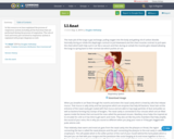
Long Description:
Authors and editors: Haley Zanga, Audrey Boraski, Alana Olendorf, Marisa Benjamin, Haley Fantasia, Simone McEwan, Jaime Marsh, Melissa Wydra, Will Trautmann, Emily Michaeles, Maddi Ouellette, Andrew Fuhs, Allie Tolles, Suki Graham, Mary Swain, Devon Audibert, Sarah Larsen, Emma Verville, Tim Brodeur, Jason Charbonneau, Christian Paparazzo, Bryce Chounard, Malisa Rai, Jennifer Rosado, Morgan Tupper

Chief Editors, final revision: Haley Zanga, Audrey Boraski, Alana Olendorf

Chief Editor, first draft: Andrew Fuhs

Managing Editors and Editorial team leaders, first draft: Bryce Chounard, Emily Michaeles, Maddi Ouellette

Word Count: 40031

(Note: This resource's metadata has been created automatically as part of a bulk import process by reformatting and/or combining the information that the author initially provided. As a result, there may be errors in formatting.)

Subject:
Biology
Life Science
Date Added:
02/02/2024
3-D Fast Plants Life Cycle Investigation Lesson Plan
Conditional Remix & Share Permitted
CC BY-NC-SA
Rating
0.0 stars

This comprehensive Open Source lesson plan is designed for Kindergarten through Middle School level students to learn about life cycles, plants needs, and plant structures & their functions through hands-on investigations with Wisconsin Fast Plants. Depending on the grade level, students engage at an appropriate depth with developing models and constructing arguments that plants have internal and external structures that function to support survival, growth, behavior, and reproduction. This lesson is available as a Google Doc in the Gather, Reason, Communicate instructional model. You may copy the lesson Doc to your own Drive and edit/adapt for your own use--it is shared by the Fast Plants Program as an Open Education Resource" therefore, you are free to use and adapt for noncommercial purposes, provided you attribute the Wisconsin Fast Plants Programs website (www.fastplants.org) as your source and share openly (for noncommercial purposes) any materials you develop with ours.

Subject:
Botany
Life Science
Material Type:
Lesson Plan
Unit of Study
Provider:
Wisconsin Fast Plants Program
Author:
Hedi Baxter Lauffer
Date Added:
05/25/2023
3D Freshwater
Conditional Remix & Share Permitted
CC BY-NC-SA
Rating
0.0 stars

This resource was created by Judy Prewett, in collaboration with Dawn DeTurk, Hannah Blomstedt, and Julie Albrecht, as part of ESU2's Integrating the Arts project. This project is a four year initiative focused on integrating arts into the core curriculum through teacher education, practice, and coaching.

Subject:
Life Science
Visual Arts
Material Type:
Lesson Plan
Author:
Arts ESU2
Date Added:
08/21/2022
3D Model of a Geologic Map
Conditional Remix & Share Permitted
CC BY-NC-SA
Rating
0.0 stars

Play-Doh model of a geologic map

Provenance: Carol Ormand Ph.D., Carleton College
Reuse: This item is offered under a Creative Commons Attribution-NonCommercial-ShareAlike license http://creativecommons.org/licenses/by-nc-sa/3.0/ You may reuse this item for non-commercial purposes as long as you provide attribution and offer any derivative works under a similar license.
Students analyze a geologic map of an angular unconformity that truncates a pair of dikes, with some topography. When students have deciphered the map and constructed a cross-section, I show them a Play-Doh model of the geology and ask them to compare it to their mental model of the area.

(Note: this resource was added to OER Commons as part of a batch upload of over 2,200 records. If you notice an issue with the quality of the metadata, please let us know by using the 'report' button and we will flag it for consideration.)

Subject:
Biology
Life Science
Mathematics
Measurement and Data
Material Type:
Activity/Lab
Provider:
Science Education Resource Center (SERC) at Carleton College
Provider Set:
Teach the Earth
Author:
Basil Tikoff, University of Wisconsin-Madison Naomi Barshi, University of Wisconsin-Madison Carol Ormand, SERC, Carleton College
Date Added:
09/01/2022
3D View from a Drone | Make a 3D Model From Your Photos
Conditional Remix & Share Permitted
CC BY-NC-SA
Rating
0.0 stars

Using cameras mounted to drones, students will design and construct an experiment to take enough photos to make a 3-dimensional image of an outcrop or landform in a process called structure from motion (SfM). This activity has both a hands-on component (collecting data with the drone) and a computer-based component (creating the 3-dimensional model).___________________Drones can take photos that can be analyzed later. By planning ahead to have enough overlap between photos, you take those individual photos and make a 3-dimensional image!In this activity, you guide the students to identify an outcrop or landform to study later or over repeat visits. They go through the process to plan, conduct, and analyze an investigation to help answer their science question.The Challenge: Design and conduct an experiment to take enough photos to make a 3-dimensional image of an outcrop or landform, then analyze the image and interpret the resulting 3-d image.For instance they might wish to study a hillside that has been changed from a previous forest fire. How is the hillside starting to shift after rainstorms or snows? Monitoring an area over many months can lead to discoveries about how the erosional processes happen and also provide homeowners, park rangers, planners, and others valuable information to take action to stabilize areas to prevent landslides.

(Note: this resource was added to OER Commons as part of a batch upload of over 2,200 records. If you notice an issue with the quality of the metadata, please let us know by using the 'report' button and we will flag it for consideration.)

Subject:
Biology
Life Science
Mathematics
Measurement and Data
Statistics and Probability
Material Type:
Activity/Lab
Provider:
Science Education Resource Center (SERC) at Carleton College
Provider Set:
Teach the Earth
Author:
Shelley Olds
Date Added:
08/27/2022