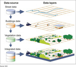
A geographic information system (GIS) is a computer system for capturing, storing, …
A geographic information system (GIS) is a computer system for capturing, storing, checking, and displaying data related to positions on Earth’s surface.
The Geographic Alliance of Iowa (GAI) was established in 1991 with the …
The Geographic Alliance of Iowa (GAI) was established in 1991 with the support of the National Geographic Society (NGS). GAI is composed of K-12 teachers, college and university professors, personnel from a variety of other educational endeavors, and citizens, all of who are concerned with improving geographic instruction in Iowa. As the only entity in Iowa specifically devoted to geography education, the mission of the Geographic Alliance of Iowa (GAI) is to help ensure K-12 graduates are geographically literate citizens. To achieve this mission, the GAI provides resources and expertise to improve the geographic literacy of Iowa students. With a particular focus on K-12 education, including pre-service teachers, the GAI provides exemplary professional development opportunities that follow accepted best practices and offers a clearinghouse of accessible, high quality, standards-based curricular materials.
In this activity, students create and interpret a water table contour map. …
In this activity, students create and interpret a water table contour map. Students utilize groundwater well elevations and the depth to the water table at each well to determine the water table elevation at each well location. Then they utilize that information to create a contour map of the water table and determine the direction of groundwater flow.
The Hotchkiss Map Collection contains cartographic items made by Major Jedediah Hotchkiss …
The Hotchkiss Map Collection contains cartographic items made by Major Jedediah Hotchkiss (1828-1899), a topographic engineer in the Confederate Army. Hotchkiss made detailed battle maps primarily of the Shenandoah Valley, some of which were used by the Generals Robert E. Lee and Thomas J. "Stonewall" Jackson for their combat planning and strategy. Several of the maps have annotations of various military officers, demonstrating their importance in the military campaigns. The collection also includes maps made or used by Hotchkiss during his post-war years, including maps with information about railroads, minerals and mining, geology and history, most of which focus on Virginia and West Virginia, but also cover other states and even the world. The collection consists of 341 sketchbooks, manuscripts, and annotated printed maps, the originals of which reside in the Library of Congress' Geography and Map Division.
This activity introduces students to using Google Earth and adding layers to …
This activity introduces students to using Google Earth and adding layers to google earth, while re-enforcing plate tectonic concepts and evidence for plate tectonics. Outcomes: 1. Download Google Earth onto computer 2. Turn on/off layers within Google Earth 3. Be able to change measurement and use ruler within Google Earth 4. Determine latitude and longitude of ocean basin features 5. Be able to search for locations within Google Earth 6. Learn to upload new layers into Google Earth from .kmz files 7. Describe different plate boundaries, their locations and boundary interactions 8. Explain evidence for Plate Tectonics
Here you can find nearly all of Iowa’s 99 counties atlases in …
Here you can find nearly all of Iowa’s 99 counties atlases in digital collection. In addition, county atlases from the late 1800s and the early 1900s are being digitized.
Iowa Culture is a mobile app that is a fun and interactive …
Iowa Culture is a mobile app that is a fun and interactive way to discover arts, history and cultural destinations in Iowa. Explore places by category and location, browse featured tours and save favorites to create your own Iowa Culture adventure. The possibilities are endless with mapping tools to direct you to more than 3,500 sites across 99 counties covering 56,272 square miles. Iowa Culture is a project by the Iowa Department of Cultural Affairs. The department empowers Iowa to build and sustain culturally vibrant communities by connecting Iowans to the people, places and points of pride that define our state.
The Iowa Digital Library features more than a million digital objects created …
The Iowa Digital Library features more than a million digital objects created from the holdings of the University of Iowa Libraries and its campus partners. Included are illuminated manuscripts, historic maps, fine art, historic newspapers, scholarly works, and more. Digital collections are coordinated by the Digital Scholarship & Publishing Studio.
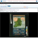
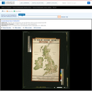
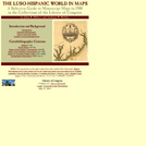
Poster showing an outline map of Ireland, with detail maps showing locations …
Poster showing an outline map of Ireland, with detail maps showing locations of noted battles. Title from item. Caption: The battles in which Irish regiments have received prominent notice are shewn above.
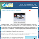
This article gives background information on the Iditarod race in Alaska and …
This article gives background information on the Iditarod race in Alaska and shows how the race can be used in Grades K-5 classrooms to incorporate science, geography and language arts. The author provides links to resources that involve reading expository tests and writing assignments as well as working with real-time data. The article appears in the free, online magazine Beyond Penguins and Polar Bears.
In this task students figure out how to draw the longest line …
In this task students figure out how to draw the longest line on a map of the United States without hitting a border. They use color and line plots to keep track of their results.
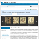
The Louisiana Purchase is a landmark event in American history, one that …
The Louisiana Purchase is a landmark event in American history, one that had a lasting impact not only on the size of the United States, but also on its economic, cultural, and political makeup. This presentation focuses on the various documents - from maps to newspapers to cultural artifacts - that help to describe the region of North America that stretched from as far east as Alabama into what is now the state of Montana.
This site includes maps created back to the early 16th century, when …
This site includes maps created back to the early 16th century, when exploration and new discoveries brought the need for improved information about the world. The maps, most of which are hand drawn, depict portions of five continents and were prepared by cartographers from Spain, Portugal, France, Great Britain, the Netherlands, Latin America countries, and the U.S., among others. The maps represent different national and political interests and perspectives, at various periods of time.
The following map analysis worksheet was designed and developed by the Education …
The following map analysis worksheet was designed and developed by the Education Staff of the National Archives and Records Administration. You may find this worksheet useful as you introduce students to maps as primary sources of historical, social and cultural information.
Whether you realize it or not, when you carry a smart phone, …
Whether you realize it or not, when you carry a smart phone, use a navigation system in your car, or look up the nearest coffee shop on your computer, you are using geographic information. Geographic data and technologies are embedded in almost all aspects of our lives. GEOG 160, Mapping Our Changing World, explores what geographic information and data are, what makes them unique, how they are created, and how we use them. You'll explore how geographic technologies like geographic information systems (GIS), remote sensing from satellites, and global positioning systems (GPS) work together to provide us with information we rely on. You'll also become an informed consumer of the geographic content in your life.
This earth systems field lab begins with an in-class guided inquiry experience …
This earth systems field lab begins with an in-class guided inquiry experience which uses Minnesota Geological Survey 3-D maps of the upper Midwest to determine where they believe glaciers may have had an influence. They will determine this by looking at landscapes and compiling their own evidence from the maps. They will also offer evidence for a hypothesis they generate which involves the direction that the glacier was traveling.
No restrictions on your remixing, redistributing, or making derivative works. Give credit to the author, as required.
Your remixing, redistributing, or making derivatives works comes with some restrictions, including how it is shared.
Your redistributing comes with some restrictions. Do not remix or make derivative works.
Most restrictive license type. Prohibits most uses, sharing, and any changes.
Copyrighted materials, available under Fair Use and the TEACH Act for US-based educators, or other custom arrangements. Go to the resource provider to see their individual restrictions.