Description here. (Note: this resource was added to OER Commons as part …
Description here.
(Note: this resource was added to OER Commons as part of a batch upload of over 2,200 records. If you notice an issue with the quality of the metadata, please let us know by using the 'report' button and we will flag it for consideration.)
This module introduces students to the fundamental principles and uses of electrical …
This module introduces students to the fundamental principles and uses of electrical resistivity, with a focus on an environmental application. Students explore the characteristics and environmental setting of Harrier Meadow, a saltmarsh just outside of New York City. They investigate the relationship between electrical resistivity and physical properties of the soil in the marsh. Students also discover how variations in survey configuration parameters control investigation depth (how far into the ground the signals sense) and spatial resolution (what size objects can be detected). Finally, students learn about and then perform geophysical inversion, which is the process of estimating the geophysical properties of the subsurface from geophysical observations. In the final unit of the module, students evaluate the extent to which the geophysical dataset and direct physical measurements support the hypothesis, introduced in Unit 1, accounting for the distribution of Pickleweed in Harrier Meadow. This module is intended to require approximately 2-3 weeks of class time. Teaching material includes PowerPoints that may be used in lectures or provided for self-guided learning, exercises, and handouts that ask students to synthesize what they learn from the exercises. In addition, multiple choice and short answer questions can be given to students as homework, on quizzes, or on exams.
(Note: this resource was added to OER Commons as part of a batch upload of over 2,200 records. If you notice an issue with the quality of the metadata, please let us know by using the 'report' button and we will flag it for consideration.)
In this exercise, students process LiDAR data for the Hamilton College campus …
In this exercise, students process LiDAR data for the Hamilton College campus area to determine accurate elevations of wellheads of sampling wells on campus. Students use both GPS readings and orthophotos to determine wellhead locations and combine those with water levels, casing heights, and wellhead elevations to interpolate a groundwater surface under the campus and portray the groundwater in ArcScene. They also learn how to use Model Builder. You might also be interested in our Full GIS course with links to all assignments. You might also be interested in our webinar for the NYS GIS Association on A Simple Example of Working with LiDAR using ArcGIS and 3D Analyst.
(Note: this resource was added to OER Commons as part of a batch upload of over 2,200 records. If you notice an issue with the quality of the metadata, please let us know by using the 'report' button and we will flag it for consideration.)
Students learn far more from doing than from viewing. By seeing relationships …
Students learn far more from doing than from viewing. By seeing relationships that they have developed themselves, by diagraming those relationships themselves, students learn far more than merely reading over what someone else has done. It is argued that especially for the dynamic problems encountered in environmental and resource economics, Excel has a comparative advantage as a learning aid. We develop a simple, flexible Excel assignment to illustrate the Brander and Taylor (1998) model of the Easter Island economy. Brander and Taylor argue that on Easter Island a crucial natural resource, the island's palm forest, was an open-access (res nullius) resource, leading to over harvesting and eventual societal collapse. Brander and Taylor's simple model showing the interaction of human population with a renewable resource, a forest, mimics what is known about the human population and forest from archaeological evidence.
The open access institutional protection of renewable resources is illustrated by a simple diagram of population and resource stock over centuries, a model much like ordinary predator-prey models in biology. Variations on the basic Brander and Taylor model, such as changes in propoerty rights institutions and/or changes in technology, based on published work in the literature, can be explored and compared to the original Brander and Taylor results of boom and eventual collapse.
Brander, J.A. and M.S. Taylor (1998). The simple economics of Easter Island: A Ricardo -- Malthus model of renewable resource use. American Economic Review
(Note: this resource was added to OER Commons as part of a batch upload of over 2,200 records. If you notice an issue with the quality of the metadata, please let us know by using the 'report' button and we will flag it for consideration.)
Students apply the main research methods in sociology to explore their personal …
Students apply the main research methods in sociology to explore their personal footprints (i.e., the global consequences of their individual actions).
(Note: this resource was added to OER Commons as part of a batch upload of over 2,200 records. If you notice an issue with the quality of the metadata, please let us know by using the 'report' button and we will flag it for consideration.)
An activity in which students use dice to explore radioactive decay and …
An activity in which students use dice to explore radioactive decay and dating and make simple calculations.
(Note: this resource was added to OER Commons as part of a batch upload of over 2,200 records. If you notice an issue with the quality of the metadata, please let us know by using the 'report' button and we will flag it for consideration.)
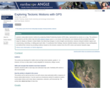
Using a map showing the horizontal velocities of GPS stations in the …
Using a map showing the horizontal velocities of GPS stations in the Plate Boundary Observatory and other GPS networks in Alaska and Western United States, students are able to describe the motions in different regions by interpreting the vectors resulting from long-term high-precision Global Positioning System (GPS) data. Show more information on NGSS alignment Hide NGSS ALIGNMENT Disciplinary Core Ideas History of Earth: HS-ESS1-5 Earth' Systems: MS-ESS2-2 Earth and Human Activity: MS-ESS3-2, HS-ESS3-1 Science and Engineering Practices 4. Analyzing and Interpreting Data 5. Using Mathematics and Computational Thinking 6. Constructing Explanations and Designing Solutions Crosscutting Concepts 4. Systems and System Models 7. Stability and Change
(Note: this resource was added to OER Commons as part of a batch upload of over 2,200 records. If you notice an issue with the quality of the metadata, please let us know by using the 'report' button and we will flag it for consideration.)
A few PowerPoint or Keynote slides are used to set the historical …
A few PowerPoint or Keynote slides are used to set the historical context of the project and to introduce the general problem (see "Presentation Files" and "Instructors Notes" below). Bouncing a rubber ball in class from differing heights above the floor, and letting students see and hear the effects of differing travel times, helps students understand that longer travel time in a reflection experiment indicates a deeper reflector. The relevant parts of YouTube videos are shown (see links under "Other Materials" below). Have the students measure the time interval between the explosion and the impact a few times while showing the videos. One of the correspondents talks about (and attempts to show) how the bridge vibrated after the explosion. Pass out the worksheet and the raw seismograms related to the Hoan demolition experiment. Then, with a copy of the seismograms projected onto the screen, hold an initial discussion of how to interpret the graphics: note the time scale, discuss what the different wave amplitudes mean, and so on. Then cluster into groups of 2-4 students and have each group try to "pick" the first arrivals of [1] the explosion-induced direct wave, [2] the impact-induced direct wave, and [3] the corresponding reflected waves. Depending on the type of students involved (intro non-geologists, intro geology/geophysics, geophysics), the teacher can provide more or less assistance in picking the arrivals of the direct and reflected waves. Work through the quantitative material on the worksheet. Questions about how to handle uncertainty always occur, and if the students do not admit to having questions about this the teacher should ask them how they handle uncertainties. In a nutshell, the resultant uncertainty associated with the sum or difference in two numbers are the sum of the two uncertainties. For example, (23 Â 2) + (14 Â 1) = 37 Â 3. The resultant uncertainty associated with the product of two numbers can be estimated with the sum of the fractional (or percentage) uncertainties. For example, the percentage uncertainty of 23 Â 2 is (2/23) or 8.7% and the percentage uncertainty of 14 Â 1 is (1/14) or 7.1 %, so (23 Â 2) x (14 Â 1) = 322 Â 51 because (8.7% + 7.1%) = 15.8% and 15.8% of 322 is ~51. For a nice summary of simple uncertainty calculations, refer to http://spiff.rit.edu/classes/phys273/uncert/uncert.html or http://webpages.ursinus.edu/lriley/ref/unc/unc.html, or the statistics resources on the SERC website. When the worksheets are completed, recap the experiment and compare the results with a map of crustal thicknesses for North America (e.g., Braile, 1989, Fig. 23B). Finally, it is nice to have the students evaluate the experience as homework.
(Note: this resource was added to OER Commons as part of a batch upload of over 2,200 records. If you notice an issue with the quality of the metadata, please let us know by using the 'report' button and we will flag it for consideration.)
In this module, students calculate the pressure at the depth of compensation …
In this module, students calculate the pressure at the depth of compensation along a cross section of North America.
(Note: this resource was added to OER Commons as part of a batch upload of over 2,200 records. If you notice an issue with the quality of the metadata, please let us know by using the 'report' button and we will flag it for consideration.)
In this module, students examine Archimede's Principle in general and as it …
In this module, students examine Archimede's Principle in general and as it applies to Isostacy.
(Note: this resource was added to OER Commons as part of a batch upload of over 2,200 records. If you notice an issue with the quality of the metadata, please let us know by using the 'report' button and we will flag it for consideration.)
Students are asked to numerically and then analytically determine the relations governing …
Students are asked to numerically and then analytically determine the relations governing the depth of compensation.
(Note: this resource was added to OER Commons as part of a batch upload of over 2,200 records. If you notice an issue with the quality of the metadata, please let us know by using the 'report' button and we will flag it for consideration.)
SSAC Geology of National Parks module/Geology of National Parks course. Students calculate …
SSAC Geology of National Parks module/Geology of National Parks course. Students calculate probabilities using USGS hydrograph data, a spreadsheet of daily stage heights, and the COUNTIF function.
(Note: this resource was added to OER Commons as part of a batch upload of over 2,200 records. If you notice an issue with the quality of the metadata, please let us know by using the 'report' button and we will flag it for consideration.)
Mark C. Rains (University of South Florida), David C. Shelley (National Parks Service) and Len Vacher (University of South Florida)
Cover page by Len Vacher, University of South Florida
This assignment asks students to do a flood frequency analysis to determine …
This assignment asks students to do a flood frequency analysis to determine the size and stage of various floods and determine if the town of Crawford, OH is likely to be flooded or not. Outcomes: learn to work with quantitative data, learn to use Excel, be able to use USGS data.
(Note: this resource was added to OER Commons as part of a batch upload of over 2,200 records. If you notice an issue with the quality of the metadata, please let us know by using the 'report' button and we will flag it for consideration.)
This lab activity has students use stream discharge data obtained from the …
This lab activity has students use stream discharge data obtained from the USGS Water Resources Division web site in order to calculate recurrence intervals for a local stream. Using the recurrence data generated, the students then make recommendations to the residents of a local town as to what they might do to reduce their loss from the effects of frequent flooding in their community.
(Note: this resource was added to OER Commons as part of a batch upload of over 2,200 records. If you notice an issue with the quality of the metadata, please let us know by using the 'report' button and we will flag it for consideration.)
Students calculate recurrence intervals for various degrees of flooding based on historical …
Students calculate recurrence intervals for various degrees of flooding based on historical data. Students then do a risk assessment for the surrounding community.
(Note: this resource was added to OER Commons as part of a batch upload of over 2,200 records. If you notice an issue with the quality of the metadata, please let us know by using the 'report' button and we will flag it for consideration.)
In this several week-long introductory geoscience project, students evaluate the potential for …
In this several week-long introductory geoscience project, students evaluate the potential for flooding in the local region. Students visit the site during the first week of the semester as part of a "Walk in the Watershed" and make observations in order to generate hypotheses about the processes that shape the landscape and control the movement of water. During a later lab period, students return to the same site to determine stream discharge using the flotation and current meter methods and compare and contrast the results from the two methods. In addition, students in the different laboratory sections use their data to compare and contrast reasons for why discharge may have changed over the course of the day or week during the following class meeting. As an in-class exercise, students examine an annual hydrograph and then predict the weather that generated the observed stream discharge. Students test their hypotheses by analyzing precipitation data available on-line in order to correlate flood events with storm types or other causes for major discharge events. Next, students examine historical flood and discharge data of the local stream available on-line at http://nwis.waterdata.usgs.gov/ as a homework assignment. In addition to calculating the recurrence interval and probability of occurrence for each event, students determine the discharge and stage of a 1-, 10-, 50-, and 100-year flood, create a rating curve, and generate a floodway map for each of these events. Subsequently, students revisit the site during lab and locate the boundaries of these flood events. Students will make recommendations for building a house in the region based on their analyses.
(Note: this resource was added to OER Commons as part of a batch upload of over 2,200 records. If you notice an issue with the quality of the metadata, please let us know by using the 'report' button and we will flag it for consideration.)
Students explore the USGS water website to identify the location of stream …
Students explore the USGS water website to identify the location of stream gauges on the Minnesota River and the types of data that can be retrieved from the website. They determine which data to download based on the area of interest in the exercise (St. Peter, MN) and import historical flood data into MS Excel. The students use a spreadsheet to rank each flood and calculate a recurrence interval for a given flood, then estimate the discharge and stage of the 100-year flood in St. Peter, MN. The final task is to establish a flood hazard zone on a topographic map of the city of St. Peter. Note: this exercise can be applied to almost any non-dammed river with two or more USGS gaging stations on it. Go to http://water.usgs.gov and select your state from the pull-down menu to view an interactive map of your state's rivers and gaging station locations.
(Note: this resource was added to OER Commons as part of a batch upload of over 2,200 records. If you notice an issue with the quality of the metadata, please let us know by using the 'report' button and we will flag it for consideration.)
This exercise looks at the dollar losses and deaths caused by flooding …
This exercise looks at the dollar losses and deaths caused by flooding in the US, and at the causes of, and relationships between the two trends.
(Note: this resource was added to OER Commons as part of a batch upload of over 2,200 records. If you notice an issue with the quality of the metadata, please let us know by using the 'report' button and we will flag it for consideration.)
No restrictions on your remixing, redistributing, or making derivative works. Give credit to the author, as required.
Your remixing, redistributing, or making derivatives works comes with some restrictions, including how it is shared.
Your redistributing comes with some restrictions. Do not remix or make derivative works.
Most restrictive license type. Prohibits most uses, sharing, and any changes.
Copyrighted materials, available under Fair Use and the TEACH Act for US-based educators, or other custom arrangements. Go to the resource provider to see their individual restrictions.