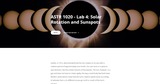
Galileo, in 1612, demonstrated that the Sun rotates on its axis with …
Galileo, in 1612, demonstrated that the Sun rotates on its axis with a rotation period of approximately one month. Our star turns in a west-to-east direction, like the orbital motions of the planets. The Sun, however, is a gas and does not have to rotate rigidly, the way a solid body like Earth does. Modern observations show that the Sun’s rotation speed varies according to latitude; that is, it’s different as you go north or south of the Sun’s equator. Between 1826 and 1850, Heinrich Schwabe, a German pharmacist and amateur astronomer kept daily records of the number of sunspots. What he was looking for was a planet inside the orbit of Mercury, which he hoped to find by observing its dark silhouette as it passed between the Sun and Earth. Unfortunately, he failed to find the hoped-for planet, but his diligence paid off with an even more important discovery: the sunspot cycle. He found that the number of sunspots varied systematically, in cycles about a decade long. In this laboratory, you will engage in tracking the Sun like Galileo and Schwabe during a six-day cycle and then do a simple calculation of the rotational period of our sun.---------------------------------------Distant Nature: Astronomy Exercises 2016 by Stephen Tuttle under license "Creative Commons Attribution Non-Commercial Share Alike".
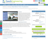
Students learn how engineers gather data and model motion using vectors. They …
Students learn how engineers gather data and model motion using vectors. They learn about using motion-tracking tools to observe, record, and analyze vectors associated with the motion of their own bodies. They do this qualitatively and quantitatively by analyzing several examples of their own body motion. As a final presentation, student teams act as engineering consultants and propose the use of (free) ARK Mirror technology to help sports teams evaluate body mechanics. A pre/post quiz is provided.
Students use bearing measurements to triangulate and determine objects' locations. Working in …
Students use bearing measurements to triangulate and determine objects' locations. Working in teams of two or three, they must put on their investigative hats as they take bearing measurements to specified landmarks in their classroom (or other rooms in the school) from a "mystery location." With the extension activity, students are challenged with creating their own maps of the classroom or other school location and comparing them with their classmates' efforts.
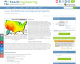
The concept of geocaching is introduced as a way for students to …
The concept of geocaching is introduced as a way for students to explore using a global positioning system (GPS) device and basic geographic information (GIS) skills. Students familiarize themselves with GPS, GIS, and geocaching as well as the concepts of latitude and longitude. They develop the skills and concepts needed to complete the associated activity while considering how these technologies relate to engineering. Students discuss images associated with GPS, watch a video on how GPS is used, and review a slide show of GIS basics. They estimate their location using latitude and longitude on a world map and watch a video that introduces the geocaching phenomenon. Finally, students practice using a GPS device to gain an understanding of the technology and how location and direction features work while sending and receiving data to a GIS such as Google Earth.
Students learn about video motion capture technology, becoming familiar with concepts such …
Students learn about video motion capture technology, becoming familiar with concepts such as vector components, magnitudes and directions, position, velocity, and acceleration. They use a (free) classroom data collection and processing tool—the ARK Mirror—to visualize and record 3-D motion. The Augmented Reality Kinematics (ARK) Mirror software collects data via a motion detector. Using an Orbbec Astra Pro 3D camera or Microsoft Kinect (see note below), students can visualize and record a robust set of data and interpret them using statistical and graphical methods. This lesson introduces students to just one possible application of the ARK Mirror software—in the context of a high school physics class. Note: The ARK Mirror is ported to operate on an Orbbec platform. It may also be used with a Microsoft Kinect, although that Microsoft hardware has been discontinued. Refer to the Using ARK Mirror and Microsoft Kinect attachment for how to use the ARK MIrror software with Microsoft Kinect.
Students create and use their own simple compasses, which are each made …
Students create and use their own simple compasses, which are each made from a bowl of water, strong magnet, stick pin and Styrofoam peanuts. They learn how compasses work and about cardinal directions. They come to understand that the Earth's magnetic field has both horizontal and vertical components.
In this activity, students will learn how to actually triangulate using a …
In this activity, students will learn how to actually triangulate using a compass, topographical (topo) map and view of outside landmarks. It is best if a field trip to another location away from school is selected. The location should have easily discernable landmarks (like mountains or radio towers) and changes in elevation (to illustrate the topographical features) to enhance the activity. A national park is an ideal location, and visiting a number of parks, especially parks with hiking trails, is especially beneficial.
Students learn how to identify the major features in a topographical map. …
Students learn how to identify the major features in a topographical map. They learn that maps come in a variety of forms: city maps, road maps, nautical maps, topographical maps, and many others. Map features reflect the intended use. For example, a state map shows cities, major roads, national parks, county lines, etc. A city map shows streets and major landmarks for that city, such as hospitals and parks. Topographical maps help navigate the wilderness by showing the elevation, mountains, peaks, rivers and trails.
In this activity, students will use vector analysis to understand the concept …
In this activity, students will use vector analysis to understand the concept of dead reckoning. Students will use vectors to plot their course based on a time and speed. They will then correct the positions with vectors representing winds and currents.
Students learn how to take bearings using orienteering compasses. They also learn …
Students learn how to take bearings using orienteering compasses. They also learn how to describe a bearing and find an object in the classroom using a bearing.
In this lab students will be able to provide and follow directions …
In this lab students will be able to provide and follow directions in groups of two. They will also learn how to interpret subway line network map and discuss when to get off at certain stations.
No restrictions on your remixing, redistributing, or making derivative works. Give credit to the author, as required.
Your remixing, redistributing, or making derivatives works comes with some restrictions, including how it is shared.
Your redistributing comes with some restrictions. Do not remix or make derivative works.
Most restrictive license type. Prohibits most uses, sharing, and any changes.
Copyrighted materials, available under Fair Use and the TEACH Act for US-based educators, or other custom arrangements. Go to the resource provider to see their individual restrictions.