Students will view, analyze, and follow prompts to consider various types of …
Students will view, analyze, and follow prompts to consider various types of land and categorize them for usage as agricultural or non-agricultural land. Activity by Wesley Davis.
The Nature of Geographic Information is an orientation to the properties of …
The Nature of Geographic Information is an orientation to the properties of geographic data and the practice of distance learning. The purpose of this course is to promote understanding of the Geographic Information Science and Technology (GIS&T) enterprise. GIS&T is the intersection of professions, institutions, and technologies that produce geographic data and render information from it. It is a rapidly growing and evolving field. Learning is a way of life for all GIS&T professionals. With this in mind, I hope that this text may contribute to your lifelong exploration of how geospatial technologies can be used to improve the quality of life-yours and your neighbors', locally and globally, now and in the future.
Concise lesson plan template asking for the 'essential question', objectives, interest approach, …
Concise lesson plan template asking for the 'essential question', objectives, interest approach, content/procedure/activity, and closure/check for understanding. Developed by Matt Kriefels.
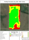
This is a fourth lesson in computing variable rate prescriptions. This lesson …
This is a fourth lesson in computing variable rate prescriptions. This lesson utilizes four different fertilizer products for meeting N, P, K and S needs of a corn crop.
Geographic information systems (GIS) are important technology that allows rapid study and …
Geographic information systems (GIS) are important technology that allows rapid study and use of spatial information. GIS have become increasingly prevalent in industry and the consumer/internet world in the last 20 years. Historically, the basis of GIS was in mapping, and so it is important to understand the basis of maps and how to use them as well as why they are different from GIS. In this lesson, students learn the value of maps, how to use maps, and the basic components of a GIS. They are also introduced to numerous GIS applications.
No restrictions on your remixing, redistributing, or making derivative works. Give credit to the author, as required.
Your remixing, redistributing, or making derivatives works comes with some restrictions, including how it is shared.
Your redistributing comes with some restrictions. Do not remix or make derivative works.
Most restrictive license type. Prohibits most uses, sharing, and any changes.
Copyrighted materials, available under Fair Use and the TEACH Act for US-based educators, or other custom arrangements. Go to the resource provider to see their individual restrictions.