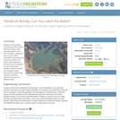
Students construct three-dimensional models of water catchment basins using everyday objects to …
Students construct three-dimensional models of water catchment basins using everyday objects to form hills, mountains, valleys and water sources. They experiment to see where rain travels and collects, and survey water pathways to see how they can be altered by natural and human activities. Students discuss how engineers design structures that impact water collection, as well as systems that clean and distribute water.
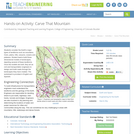
Students consider the Earth's major types of landforms such as mountains, rivers, …
Students consider the Earth's major types of landforms such as mountains, rivers, plains, hills, canyons, oceans and plateaus. Student teams build three-dimensional models of landscapes, depicting several of these landforms. Once the models are built, they act as civil and transportation engineers to design and build roads through the landscapes they have created. The worksheet is provided in English and Spanish.
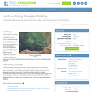
Students explore the impact of changing river volumes and different floodplain terrain …
Students explore the impact of changing river volumes and different floodplain terrain in experimental trials with table top-sized riverbed models. The models are made using modeling clay in aluminum baking pans placed on a slight incline. Water added "upstream" at different flow rates and to different riverbed configurations simulates different potential flood conditions. Students study flood dynamics as they modify the riverbed with blockages or levees to simulate real-world scenarios.
This course presents a topical approach to landform analysis and process. Map …
This course presents a topical approach to landform analysis and process. Map interpretations are used to demonstrate relationships to constructive and destructive processes during landform development. Planning economic and social considerations are examined.
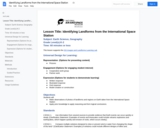
This lesson presents several images taken from the International Space Station and …
This lesson presents several images taken from the International Space Station and challenges students to identify the land forms and their locations on Earth.
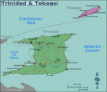
There are many different landforms in Trinidad and Tobago. They are shaped …
There are many different landforms in Trinidad and Tobago. They are shaped by forces deep within the planet and by conditions on the earth surface. In this learning plan, students will learn about some natural landforms in Trinidad and Tobago. They will be allowed to learn how to appreciate their natural environment.
In this lesson, students learn about major landforms (e.g., mountains, rivers, plains, …
In this lesson, students learn about major landforms (e.g., mountains, rivers, plains, valleys, canyons and plateaus) and how they occur on the Earth's surface. They learn about the civil and geotechnical engineering applications of geology and landforms, including the design of transportation systems, mining, mapping and measuring natural hazards.
No restrictions on your remixing, redistributing, or making derivative works. Give credit to the author, as required.
Your remixing, redistributing, or making derivatives works comes with some restrictions, including how it is shared.
Your redistributing comes with some restrictions. Do not remix or make derivative works.
Most restrictive license type. Prohibits most uses, sharing, and any changes.
Copyrighted materials, available under Fair Use and the TEACH Act for US-based educators, or other custom arrangements. Go to the resource provider to see their individual restrictions.