Unrestricted Use
Public Domain
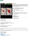
This circular from the USGS contains paired satellite images (one from the 1970s and one from the 1990s) of 16 American cities, showing changes in urban land use during this period. Each image pair is accompanied by historical geography information that helps explain the context of the images.
- Subject:
- Geoscience
- Physical Science
- Social Science
- Material Type:
- Diagram/Illustration
- Provider:
- Science Education Resource Center (SERC) at Carleton College
- Provider Set:
- Starting Point: Teaching Entry Level Geoscience
- Author:
- Janis Taylor
- Roger Auch
- USGS
- William Acevedo
- Date Added:
- 11/07/2014