World History: Cultures, States, and Societies (Global Remix)
Defining "Civilization"
The term civilization often elicits mostly idealized images of ancient empires, monumental architecture, and the luxurious lives of ruling classes. Civilization, however, is a tricky term. In the United States, students of history studied Western Civilization, almost exclusively, through the 1950s. In their studies, civilizations were advanced societies with urban centers, rooted in European or Middle Eastern culture. America’s origins in these western civilizations was used to explain our own high level of development. However, more recent scholars have definitely broadened the geographical focus by recognizing that worldwide from 3500 to 1000 BCE at least seven independent civilizations emerged in different regions. These recent scholars also continue to debate the definition of civilization, and the current compromise amongst World Historians is to recognize characteristics that civilizations tended to share. Common characteristics of civilizations included food surpluses, higher population densities, social stratification, systems of taxation, labor specialization, regular trade, and accumulated learning (or knowledge passed down from generation to generation). The list here is not all-inclusive by any means, but it indicates the complexity of the societies that scholars have labeled civilizations.
In addition to heated debates about its exact definition, civilization is a loaded term, meaning that it can contain a value judgment. If we use the term carelessly, it seems to indicate that some societies are deemed civilized and worthy of inclusion, while others are uncivilized and thus not worth our study. In part, our sensitivity to this issue is a response to the tendency of past historians, including many of those working in Europe in the 1800s, to assume that there was a natural progression from an uncivilized state to civilization. These historians viewed people who had values, ways of living, and religious beliefs di erent than theirs as uncivilized. They further believed that these allegedly uncivilized peoples were behind or needed to catch up with those who were civilized. Today, World Historians try to appreciate the great diversity of human experiences and consciously remove these sorts of value judgments. World Historians avoid assumptions that some societies in the past were better or further along than others. Therefore, many World Historians remain wary of the uncritical use of the term civilization.
For our purposes, let us leave aside any value judgments. Societies labeled as civilizations were not inherently better than any others. In fact, as we will see, civilizations demonstrated various vulnerabilities. Considering things like war, slavery, and the spread of diseases, there were sometimes advantages to living outside the nexus of civilizations. For example, in comparing societies, scholars have found that in many instances people residing in decentralized states were healthier and lived longer than did their counterparts in early civilizations. However, people living in societies with social stratification, labor specialization, and trade usually left more written records and archeological evidence, which historians can analyze to narrate our past. The available resources mean that civilizations tend to be better represented in the written historical records. As you read about past civilizations, keep in mind that historians are currently enhancing our understanding of societies that perhaps remained mobile, rejected hierarchies, or preserved their histories orally. These societies were also part of our shared past, even if they are harder to study or have received less scholarly attention.
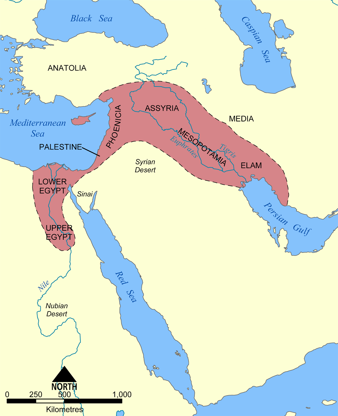
This chapter focuses on early civilizations throughout Afro-Eurasia. Civilizations in the Fertile Crescent and Northeast Africa left written records. They also all initially had economies based on farming and developed alongside rivers. Their locations alongside rivers allowed populations in the Fertile Crescent and Northeast Africa to grow the surplus food that they used to support urbanization, social stratification, labor specialization, and trade. The Harappan civilization of the Indus River Valley in South Asia left artifacts in a language we have not yet deciphered, but also left behind impressive and fairly well-preserved archaeological ruins. In East Asia, archaeologists have studied artifacts such as pottery to determine the location and development of societies.
Questions to Guide Your Reading
- Explain why the Tigris and Euphrates Rivers were significant for ancient Mesopotamians.
- Describe the characteristics of civilizations that were found in ancient Mesopotamia.
- How did the Nile River and the region’s climate and geography in uence the development of Egyptian civilization?
- Which characteristics of civilizations were seen in Ancient Egypt?
- How did the Geography of South Asia (India) impact its history?
- What are the limits of our knowledge of Harappan Civilization?
- During China's Neolithic Age, how did Longshan culture differ from Yangshao culture?
Key Terms
- Anyang
- Bay of Bengal
- Cataract
- China proper
- City-states
- Civilization
- Coromandel Coast
- Cuneiform
- Deccan Plateau
- Desiccation
- East Asia
- Ganges River
- Harappan/Indus Valley Civilization
- Hieroglyphics
- Hindu Kush
- India
- Indo-European
- Indus River
- Indo-Gangetic Plain
- Korean Peninsula
- Longshan Culture
- Malabar Coast
- Mesopotamia
- Mohenjo-Daro
- Nile River
- North China Plain
- Old Kingdom
- Ostraca
- Palette of Narmer
- Polytheistic
- Punjab
- Pyramids
- Sargon of Akkad
- Seals (Harappan/Indus Valley Civilization)
- Sindh
- South Asia
- Sri Lanka
- Sumerian King List
- Yangshao Culture
- Yangzi River
- Yellow River
- Xia Dynasty
- Ziggurat
Ancient Mesopotamia
Mesopotamia is located in an area known as the Fertile Crescent. Archeologists have found some of the earliest known sites of agricultural production in the Fertile Crescent. Although much of this region received little or irregular rainfall, the Tigris and Euphrates Rivers provided large amounts of freshwater, facilitating agricultural production and the development of early civilizations. The Greeks later recognized the significance of the river systems to these ancient societies and referred to the region as “the Land between the Rivers” or Mesopotamia.
The Fertile Crescent | Author: user "Ras67" | Source: Wikimedia Commons | License: CC BY-SA 3.0
The Tigris and Euphrates Rivers both originate in the Taurus Mountains of eastern Anatolia and flow southward to empty into the Persian Gulf. The rivers carry and deposit silt downstream, enriching the soil. In general, the richer soils and availability of water in areas that in the north otherwise had little rain, or else towards the south had concentrated months of rainfall followed by long, dry spells, encouraged settlement near the rivers. The areas closer to the Persian Gulf, known as Lower Mesopotamia, in particular, were attractive to early settlers because they had extremely fertile soils. People built some of the earliest cities, including Uruk, Eridu, and Ur, in Lower Mesopotamia.
While the Tigris and Euphrates Rivers did provide water to the region, their floods were unpredictable and could even be catastrophic when they washed away entire settlements. In response, the region’s residents created irrigation canals and drainage ditches to control the flow of water. They also stored water in reservoirs to use during the dry months of the year. Additionally, in parts of Lower Mesopotamia, the courses of the rivers and their tributaries changed frequently, so people either had to move to follow the water’s new path or divert a river to continue supplying water for their settlement. As regular access to water supported agricultural surpluses and population growth, people tended to fare better against the unpredictability of the floods, seasonal changes, and the rivers’ changing courses when they lived in settlements capable of maintaining irrigation canals, drainage ditches, and water reservoirs.
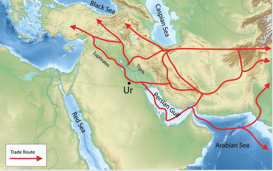
In the third millennium BCE, people in Lower Mesopotamia used river routes to trade northward. They also used sea routes through the Persian Gulf, and they connected with traders to the east by crossing the Iranian Plateau. | Author: Corey Parson | Source: Original Work | License: CC BY-SA 4.0
The rivers offered another benefit to ancient Mesopotamians. Just as the rivers were definitely important to meet people’s everyday needs for water and for agricultural production, so they also facilitated trade. While people made use of local resources, like mud to build their homes, in general, Lower Mesopotamia lacked other desired resources, including wood, stone, and precious metals. Traders were able to use the rivers to bring in these resources from Assyria, Anatolia, the Levant, and areas adjacent to the Persian Gulf. Early Mesopotamians also obtained goods from as far away as what today are northern Pakistan and India. Merchants used overland routes that crossed the Iranian Plateau and sea routes, exchanging Mesopotamian products like grains and textiles for luxury goods from the east. Royal cemeteries show that by 2500 BCE Mesopotamian elites were buried with a variety of imports, including beads brought from the Indus River Valley. The rivers and the overland trade routes also facilitated communication and, with it, the sharing of ideas and technologies.
Sumerian City-States
Lower Mesopotamia, or the southern areas of Mesopotamia towards the Persian Gulf, drew settlers, who moved to take advantage of rich soils and the availability of water in the area commonly known as Sumer. The people who lived in Sumer are generally referred to as Sumerians. Prior to 3000 BCE, Sumerians, whose origins remain a subject of debate, founded a number of independent cities in Lower Mesopotamia. In these cities, Sumerians had organized religions, centralized governments, social hierarchies, and access to trade networks. As these cities expanded, their leaders claimed control over adjacent territories, forming at least a dozen city-states, which became the basic organizational structure of Sumerian civilization in the third millennium BCE. By incorporating the surrounding territories into city-states, urban centers were able to draw on more resources.
Sumerian cities had certain characteristics in common. First, a temple complex or a ziggurat was usually the visual focus of the urban landscape. Sumerians believed that their entire city belonged to its main deity, and built a massive temple, the most important building in the city, to be the dwelling place of their city’s main god or goddess. A complex that comfortably housed many of the priests and priestesses who served the city’s deity surrounded each temple. In addition to attending to the religious needs of the community, temples complexes also owned land, managed industries, were involved in trade, and acted as banks. Their wide-ranging roles meant that temples often had additional outbuildings, like granaries and storage sheds, in the surrounding countryside. Sumerians were polytheistic, meaning they worshipped multiple gods and goddesses. Because Sumerians believed each god had a family, they also built smaller shrines and temples dedicated to these divine family members. Therefore, each city would have a number of temples while many Sumerian homes had small altars dedicated to other gods. Sometimes, urban temples or ritual spaces were built atop a ziggurat, a solid rectangular tower made of sun-dried mud bricks.

The Great Ziggurat of Ur | Located in what is today the Dhi Qar Province of Iraq, Sumerians originally built the ziggurat in the Third Dynasty of Ur (c. 2100 BCE). It has been restored several times since, including fairly recently in the 1980s. | Author: User "Tla2006" | Source: Wikimedia Commons | License: Public Domain
Archaeological evidence shows that temple complexes were expanded and rebuilt over time and, by the late third millennium BCE, temples in many of the Sumerian city-states were raised on platforms or else situated on a ziggurat. The towering architecture of the ziggurat stressed the significance of the temple to the surrounding community. The best- preserved ziggurat, the Great Ziggurat of Ur, was constructed with an estimated 720,000 baked bricks and rose to a height of about 100 feet. The people of Ur constructed this ziggurat for their patron deity, the moon goddess Nanna. They likely brought regular offerings to Nanna and also received food rations from the Great Ziggurat of Ur.
Viewing nature as unpredictable, people brought offerings to their city’s temple complexes or ziggurat, hoping to please the gods who controlled the natural forces of their world. Priests and priestesses collected and redistributed the offerings, demonstrating the vital roles they played in Sumerian society. The relatively privileged position of priests and priestesses at the temple complex also shows Sumerian social stratification (the development of a hierarchy) and how agricultural surpluses supported the specialization of labor. Some of the early leaders of Sumerian cities may have been “priest-kings,” who attained elevated positions through their association with the temples. The later rulers of city-states definitely supported the temples, claiming to be acting on behalf of the gods who brought divine favor to their followers.
Sumerian city-states had local rulers, who lived in large palaces, but most of these local rulers were not considered kings. So far, archeologists have dated the earliest known royal palaces to c. 2600 BCE and conclude that Sumerian city-states had centralized governments with secular rulers by at least that timeframe. While there does seem to have been a sense of inhabiting a shared space in Southern Mesopotamia, referred to as “the Land” in written records, city-states had distinctive identities. In part, their distinctive identities revolved around their main deity. The rulers of city-states alternately supported, competed with, and fought against one another. The Sumerian King List, a manuscript that listed early kings and described their reigns (with some presumably fictive and exaggerated elements), provides evidence of these alliances, competition, and war. For example, it describes En-mebarages as the second to last king of the 1st Dynasty of Kish, “...who carried away as spoil the weapons of the land of Elam, became king, and reigned 900 years...”[23] Local rulers often came to power after proving themselves militarily.
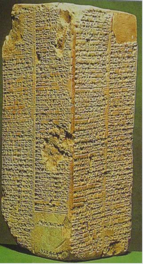
The Sumerian King List | Author: Taiwania Justo | Source: Wikimedia Commons | License: Public Domain
Furthermore, the Sumerian King List recognized only rulers who had established control over multiple city-states as kings (with the title of lugal in the Sumerian language) belonging to distinct dynasties. While it lasted, a dynasty generally passed down the kingship through the male line. According to the Sumerian King List, the seat of power, held by hereditary kings, shifted from city-state to city-state with the rise and fall of dynasties through the third millennium BCE. Significantly, the Sumerian King List began its recorded history “when kingship came down from heaven,” legitimizing secular kings through their association with gods.[24] Sumerian kings, often along with more local rulers, led armies, collected taxes, organized labor for state projects, and meted out justice. At the top of the hierarchy and with control over multiple city-states, kings expected obedience from local rulers and their subjects, and support from the priests and priestesses of the temples.
Kings, local rulers, priests, and priestesses held influential positions in Sumerian societies. However, farmers, taken as a whole, made up an estimated 90% of the population. Other skilled people included animal-breeders, merchants, craftspeople, fishermen, doctors, soldiers, architects, and scribes. Surplus agricultural production collected as tribute as well as wealth generated by trade supported such labor specialization. One important outcome of labor specialization was innovation in metalworking. In approximately 2900 BCE, metalworkers began producing bronze, which was stronger than copper. Stronger weapons and farming tools gave Sumerians advantages when it came to combat and agricultural production.
Social stratification is further evident as some Sumerians and even institutions, including temples, owned slaves. Slaves performed a variety of tasks like construction, weaving, agricultural and domestic labor, tending animals, and even administrative work as scribes. Some slaves were chattel slaves, meaning that society treated them as property with no rights. Usually, chattel slaves were prisoners of war or slaves bought from outside communities. They were branded by barbers or tattoo artists and forced to work at the will of their masters. If they tried to run away, the law required slaves to be returned. The more widespread type of servitude in most Sumerians societies was likely debt slavery, which was generally temporary until a debtor paid off a loan and its interest. Over the past century or so, archaeologists have added a great deal to our understanding of Sumerian social distinctions through their work at numerous excavation sites, but many gaps in our knowledge still exist. The archaeological discovery of cuneiform tablets at these excavation sites has aided efforts to learn about this civilization.
Sumerians developed cuneiform, a written script of wedge shaped marks, around 3200 BCE. Cuneiform was one of the earliest, if not the very first, written script in the world. The Sumerian King List, discussed above, was recorded in cuneiform. Merchants, scribes, administrators, priests, and others kept written records describing financial transactions, court proceedings, administrative decisions, and architectural plans. They also wrote legends, epic poems, chants, and prayers. Most people were not literate, so scribes—who had been specially trained in scribal schools—generated many of the records. While in school, in addition to copying written passages, scribes learned arithmetic. The Sumerians' system of arithmetic was based on the number 60, which we still use to divide time into hours, minutes, and seconds. Scribes used styluses made of reed to write on clay tablets that were dried and could be stored. The discovery of cuneiform tablets has greatly aided archaeologists, but only a small percentage of the tablets found to date have been translated.

Cuneiform script on a clay tablet currently housed at the National Archaeological Museum in Tehran. | Author: A. Davey | Source: Wikimedia Commons | License: CC BY 2.0
Using archaeological and written evidence, scholars have pieced together what they can about everyday life for Sumerians, though some questions remain. For instance, it has been a challenge to determine the layout of urban spaces beyond the prominence of the temples and the relative grandeur of palaces. From archaeological finds, scholars suspect that Sumerian cities were divided into neighborhoods by occupation and according to kinship groups, but uncertainties about specifics linger. Legal documents and tax records show that people owned property in both the cities and the countryside. Also, evidence suggests social stratification, as some Sumerians owned fairly large chunks of land, while others had much smaller plots or presumably no land at all. Wills, court proceedings, and temple documents show that land and temple offices were usually bought or else acquired through military or other service to the state. A man inherited land, property, offices, and their attendant obligations to the state (like reoccurring military service) from his father. The eldest son seems to have frequently inherited a larger share than younger brothers and have been given control over the family home. He was tasked with performing regular rituals to honor dead ancestors, who were usually buried underneath the home. From the written documents, we also get glimpses into other aspects of Sumerian life, like marriage and divorce.
Sumerians viewed marriage as a contract between two families and, as a result, the male heads of the two families arranged a couple’s marriage. Documents show that both families contributed resources to seal the union or complete the marriage contract. The man’s family gave gifts or money and hosted a feast, while the woman’s family amassed a dowry. Although a woman did not automatically receive an inheritance upon the death of her father, she could expect (and use the court system to make sure she got) to receive a dowry, even if it came from her father’s estate after his death. Divorce was possible but sometimes led to social ostracism or even punishment if there were accusations of misconduct, such consequences being especially the case for the woman. Records indicate that polygamy was not common, but wealthier men did keep slave-girls as concubines. Overall, Sumerians considered marriage an essential institution in that it brought families together and ensured the continuation of the family lineage.
Legends, myths, poems, and literary texts tell us about Sumerians, too. For example, we can explore their values and views of the afterlife through reading the Epic of Gilgamesh. The Epic of Gilgamesh relates the adventures of Gilgamesh, a legendary king, who may have lived around 2700 BCE. The epic has multiple versions and was told orally before it was first written down in cuneiform in about 2000 BCE. The epic follows the heroic exploits of Gilgamesh and his companion, Enkidu, to emphasize the importance of values such as loyalty and humility. In one section, the epic describes a very gloomy afterlife where “people see no light, they sit in darkness,”[25] reflecting Mesopotamian beliefs that the afterlife was miserable for all, even those who had lived virtuously. Additionally, it portrays the environment as potentially violent and hostile as in its flood story, which in some ways resembles the account of Noah and the flood found in Genesis. Ultimately, Gilgamesh fails at his quest to find eternal life but learns to work for the glory of the gods and for worthwhile human achievements.
Other archaeological finds and the written documents also give some hint of the wider popular culture and artistic conventions in ancient Mesopotamia. For example, cuneiform tablets with pictures of dancers and singers, as well as instruments found in graves, suggest that Sumerians placed importance on music, using it for entertainment and ritual purposes. Trying to learn more about Sumerian music, scholars and other enthusiasts have replicated these instruments and presented their best estimation of Sumerian scales and tuning. The documentary evidence suggests that hymns from the ancient Sumerian city-states were shared with later Mesopotamian empires and even spread into the Mediterranean world.
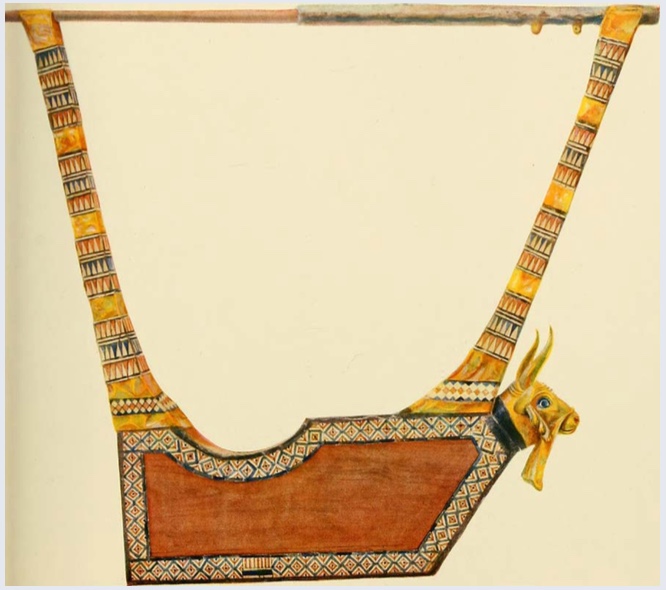
The Queen’s Lyre is a reconstructed musical instrument modeled after a lyre found by archaeologist Leonard Wooley in one of the graves at the Royal Cemetery of Ur. The original instrument has been dated to c. 2500 BCE. The reconstructed instrument is held at the British Museum in London. | Author: User “Fae” | Source: Wikimedia Commons | License: Public Domain
The Akkadian Empire
In the second half of the third millennium BCE, Sumerian city-states fought each other, and dynasties rose and fell. Kings consolidated power over multiple city-states in the region. Then, King Sargon of Akkad enlarged the scale by conquering the Sumerian city-states and parts of Syria, Anatolia, and Elam. In doing so, he created one of the world’s first empires in approximately 2334 BCE. For generations, Mesopotamian literature celebrated the Akkadian Empire (c. 2334 – 2100 BCE) that King Sargon founded. Like the Akkadian Empire, three subsequent empires, the Babylonian Empire (c. 1792 – 1595 BCE, see Chapter 3), the Assyrian Empire (c. 900 – 612 BCE, see Chapter 4) and the Neo-Babylonian Empire (c. 605 – 539 BCE, see Chapter 4), also ruled large parts of Mesopotamia and the Fertile Crescent.
Sargon of Akkad founded the first empire in Mesopotamia. Legends about Sargon of Akkad stress that he rose from obscurity to become a famous, powerful king. While the legends all tend to describe him as coming from humble origins and rising to the top using his own wits, there are many variations. One much later Babylonian tablet, from the seventh century BCE, describes his background as descendent of a high priestess and an anonymous father. His mother hid her pregnancy and the birth of Sargon, secreting him away in a wicker basket on a river, where he was rescued and then raised by Aqqi, a water-drawer. This version of the legend links Sargon with a more elite family through his birth-mother, a high priestess, but also shows how he had to advance himself up to king after being adopted by the rather more humble figure of a water-drawer.
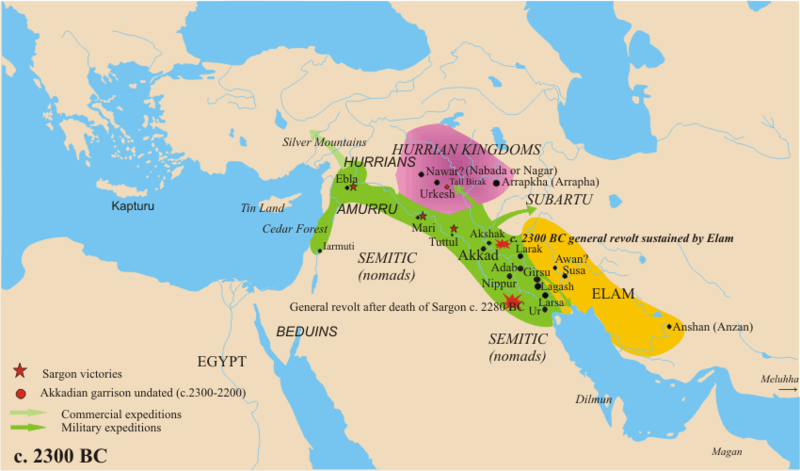
The Akkadian Empire, c. 2300 BCE | Author: User “Nareklm” | Source: Wikipedia | License: CC BY-SA 3.0
From his allegedly humble origins, Sargon of Akkad conquered Sumerian city-states one by one, creating an empire, or a large territory, encompassing numerous states, ruled by a single authority. It’s quite possible that Sargon of Akkad’s predecessor, who claimed to rule over the large region stretching from the Mediterranean Sea to the Persian Gulf, began the process of building the empire, but Sargon is remembered for accomplishing the task. One of the reasons we attribute the empire to him is his use of public monuments. He had statues, stellae (tall, upright pillars), and other monuments built throughout his realm to celebrate his military victories and to build a sense of unity within his empire. Archaeologists have not found the empire’s capital city, Akkad. However, from the available information, archaeologists have estimated its location, placing it to the north of the early Mesopotamian city-states, including Ur and Sumer. It is clear that Sargon of Akkad turned the empire’s capital at Akkad into one of the wealthiest and most powerful cities in the world. According to documentary sources, the city’s splendor stood as another symbol of Sargon’s greatness. The city grew into a cosmopolitan center especially because of its role in trade. Akkadian rulers seized and taxed trade goods, with trade routes extending as far as India. Sargon ruled the empire for over fifty years. His sons, grandson, and great grandson attempted to hold the empire together. After about 200 years, attacks from neighboring peoples caused the empire to fall. After the fall of the Akkadian Empire, Hammurabi founded the next empire in the region in 1792 BCE.
Ancient Egypt
In our study of World History, ancient Egypt serves as an excellent example of a complex society with cross-cultural connections, adaption to and control over changing environments, and sophisticated political and religious developments. All of these themes are evident in an examination of the origins of Egypt. Egyptian leaders uni ed Upper and Lower Egypt around 3100 BCE, creating a powerful ancient state. Developments in the millennia preceding uni cation, including the sharing of innovations and responses to environmental change, set the stage for the emergence of the Egyptian civilization.
Cross-cultural connections introduced the people of Northeast Africa to domesticated wheat and barley, two of the crops that they grew and whose surpluses supported the process of social differentiation and eventually the pharaonic, elite, and skilled classes of ancient Egypt. People in Northeast Africa had likely been gathering wild barley since before 10000 BCE. However, sharing in the knowledge spreading from the Fertile Crescent around 7000 BCE, they began cultivating wheat and barley and also keeping domesticated animals, including sheep and goats. At that time, agricultural production and herding were possible in areas that are today part of the Sahara Desert. The period was much wetter than now. People in the region settled into small communities, and archaeological evidence of hearths, grinding stones, and storage silos show the growth of settlements in areas that today are not well watered enough for agricultural production. The presence of crocodile bones, along with similar pottery styles, also suggest a history of contact between communities emerging along the Nile River and these settlements farther west. However, environmental change was leading to the desiccation or drying out of areas not adjacent to the Nile River, and by about 5,000 BCE, it was no longer possible to farm much beyond the floodplain of the Nile River. Many people adapted by moving towards the Nile River, and the Nile River became increasingly important to Egypt’s populations.
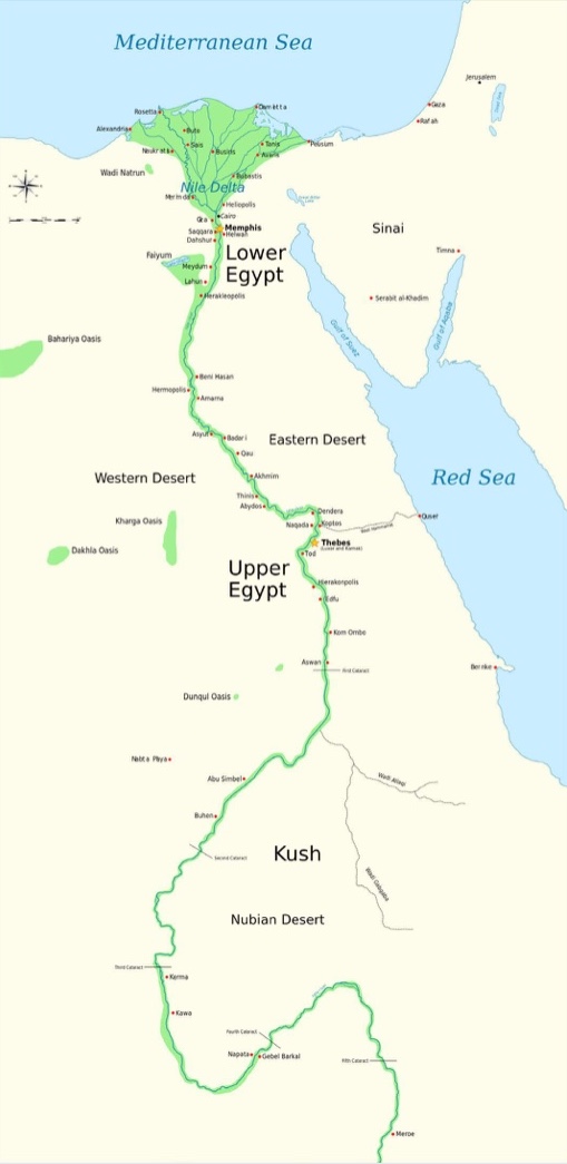
The Nile River flows south to north, fed by two main river systems: the White Nile and the Blue Nile. The White Nile ows steadily throughout the year and has its origins in the Great Lakes Region of East Africa. The Blue Nile originates in the Ethiopian highlands, and brings floodwaters up past the first cataract in the summers. (The first cataract lies roughly at Aswan) Cataracts are generally considered impassable by boat due to their shallows, rocks, and rapids. Comparatively, the flood plain of the Nile River is narrow, leading, especially with the desiccation of the surrounding areas, to high population densities close to the river. The winds also blow north to south, in the opposite direction of the river flow, thus facilitating trade and contact between Upper Egypt (to the south) and Lower Egypt (to the north). Upper and Lower Egypt lie north of the first cataract, usually allowing river traffic to proceed uninterrupted throughout the territory. Egyptian views of the Nile generally recognized the river’s centrality to life as demonstrated in the “Hymn to the Nile,” dated to approximately 2100 BCE. The praise-filled ode to the Nile River begins, “Hail to thee, O Nile! Who manifests thyself over this land, and comes to give life to Egypt.”[25] The course of the Nile River definitely impacted settlement patterns, while the river also allowed for trade and the development of larger agricultural communities.

The Path of the Nile | The White Nile originates near Lake Victoria, in the Great Lakes region of East Africa. The Blue Nile flows from the Ethiopian Highlands. Both rivers merge at Khartoum, in present day Sudan, and ow northward to empty into the Mediterranean Sea. | Author: User “Hel-hama” | Source: Wikimedia Commons | License: CC BY-SA 3.0
At the tail end of that era of desiccation, from about 3600 to 3300 BCE, complex societies formed in areas adjacent to the Nile River. These communities exerted increased in uence over their environments, exhibited social differentiation, and showed evidence of labor specialization. For example, people in the settlements of Naganda and Hierakonpolis in Upper Egypt cleared trees and built dykes, canals, and early irrigation systems. By about 3500 BCE, they used these methods to quadruple the amount of cleared, arable land and could support population densities of up to one thousand people per square mile. Just as one example, recent archaeological nds at Hierakonpolis also show evidence of both social di erential and specialization with separate burials for the settlement’s elite, the oldest known painted tomb, and the remnants of a large-scale brewery, capable of producing up to 300 gallons of beer a day. It is believed that early leaders in Naganda, Hierakonpolis, and similar communities cemented their roles by claiming control over the environment as rainmakers or commanders of the oods. Over time, some of these leaders created divine kingships, asserting their right to even more power and access to resources, power that they legitimized by claiming special relationships with, or even descent from, gods. Once Egypt was unified, pharaohs ruled as divine kings, as the personification of the gods. They promised order in the universe. When things went well, the pharaohs were credited with agricultural productivity and the success of the state. There was no separation between religion and the state in ancient Egypt.
The Palette of Narmer, which is used to date the unification of Egypt, shows signs that King Narmer legitimized his rule, in part, by claiming a special relationship with the gods. King Narmer, who is referred to in some text as Menes, is commonly recognized as the first unifier of Upper (to the south) and Lower (to the north) Egypt in approximately 3100 BCE. Unification brought together Egypt from the first cataract at Aswan to the Nile Delta. The Palette of Narmer, which was found in Hierakonpolis, shows King Narmer’s conquest of both regions. The right side in Figure 2.6 shows him slaying an enemy of Upper Egypt. The largest figure, Narmer is wearing the crown of Upper Egypt and beheading a rival king, while standing atop conquered enemies. The left side also shows him as a conqueror, wearing the crown of Lower Egypt and directing ag bearers to mark his victory. Religious imagery appears in the inclusion of the goddess Hathor at the top of the palette as well as the falcon, a reference to Horus, the patron god of Hierakonpolis, who later in dynastic Egypt became the god of sun and kingship.
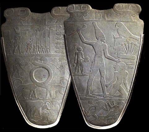
Both Sides of the Palette of Narmer | Author: User “Jean88” | Source: Wikimedia Commons | License: CC0 1.0
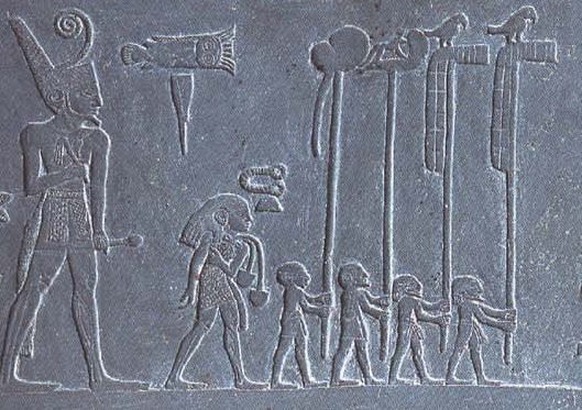
Close- up of the left side of the Palette of Narmer. Note the larger figure of King Narmer, with celebratory flag bearers preceding him. | Author: User “NebMaatRa” | Source: Wikimedia Commons | License: CC BY-SA 3.0
Both sides of the Palette of Narmer also have some of the earliest known hieroglyphs. Hieroglyphics emerged as written text, combining pictograms (a pictorial symbol for a word or phrase) and phonograms (a symbol representing a sound), during the period of uni cation. Tax assessment and collection likely necessitated the initial development of Hieroglyphics. Ancient Egyptians eventually used three different scripts: Hieroglyphic, Hieratic, and Demotic.
Hieroglyphics remained the script of choice for ritual texts. Students of Egyptian history are most familiar with hieroglyphics as they were usually what artists used to record the history of Egypt’s elite. For example, skilled artisans used hieroglyphs to chronicle glorified accounts of their patrons’ lives on the sides of their tombs. The Egyptians developed Hieratic and Demotic, the two other scripts, slightly later and used them for administrative, commercial, and many other purposes. The Egyptian administration tended to use ink and papyrus to maintain its official records. On the other hand, literate people used ostraca, pieces of broken pottery and chips of limestone, for less formal notes and communications. Over the past decades, archaeologists have uncovered a treasure trove of ostraca that start to tell us about the lives of the literate elite and skilled craftsmen. Just like Mesopotamia, ancient Egypt had one of the oldest written scripts found anywhere in the world.
In addition to one of the earliest writing systems and Egyptian paper (papyrus), archaeologists have credited ancient Egyptians with a number of other innovations. For construction purposes, ancient Egyptians invented the ramp and lever. They also developed a 12-month calendar with 365 days, glassmaking skills, arithmetic (including one of the earliest decimal systems) and geometry, and medical procedures to heal broken bones and relieve fevers. Finally, Egyptians used stone-carving techniques and other crafting skills and tools that were shared throughout the Mediterranean.
Dynastic Egypt
Scholars break the 1500 years following unification, a time known as dynastic Egypt, into three main periods: the Old Kingdom (c. 2660–2160 BCE), the Middle Kingdom (c. 2040 – 1640 BCE), and the New Kingdom (c. 1530–1070 BCE). There is some disagreement about the exact dates of the periods, but, in general, these spans denote more centralized control over a uni ed Egypt. During dynastic Egypt, pharaohs ruled a united Upper and Lower Egypt. In between these periods of centralized control were intermediate periods, during which the Egyptian pharaohs had less authority. The intermediate periods were characterized by political upheaval and military violence, the latter often at least partially resulting from foreign invasions.
Striking continuities existed in Egypt throughout the Old Kingdom, the Middle Kingdom, and the New Kingdom. Egypt had stable population numbers, consistent social stratification, pharaohs—who exercised significant power—and a unifying religious ideology, which linked the pharaohs to the gods. As Egypt transitioned from the period of unification under King Narmer to the Old Kingdom, the pharaohs and the elite became increasingly wealthy and powerful. They further developed earlier systems of tax collection, expanded the religious doctrine, and built a huge state bureaucracy.
Social distinctions and hierarchies remained fairly consistent through all of dynastic Egypt. Most people were rural peasant farmers. They lived in small mud huts just above the flood plain and turned over surplus agricultural produce to the state as taxes. When they weren’t farming, they were expected to perform rotating service for the state, by, for example, working on a pharaoh’s tomb, reinforcing dykes, and helping in the construction of temples. The labor of the majority of the population supported the more elite and skilled classes, from the pharaoh down through the governing bureaucrats, priests, nobles, soldiers, and skilled craftspeople, especially those who worked on pyramids and tombs. (Visit the following link for a diagram of the Egyptian social hierarchy).
Upper and Lower Egypt | Note the narrowness of the floodplain, marked in green. The narrow floodplain, usually not more than 15 miles wide and often considerably less, encouraged high population densities close to the Nile River. | Author: Jeff Dahl | Source: Wikimedia Commons | License: CC BY-SA 4.0
Another continuity in dynastic Egypt was the relative equality of women to men. At least compared to women in other ancient societies, women in ancient Egypt had considerable legal rights and freedoms. Men and women did generally have different roles; Egyptian society charged men with providing for the family and women with managing the home and children. Society’s ascribed gender roles meant that women were usually de ned primarily by their husbands and children, while men were de ned by their occupations. This difference could leave women more economically vulnerable than men. For example, in the village of craftspeople who worked on the pharaoh’s tomb at Deir el Medina, houses were allocated to the men who were actively employed. This system of assigning housing meant that women whose husbands had died would be kicked out of their homes as replacement workers were brought in. Despite some vulnerability, Egyptian law was pretty equal between the sexes when it came to many other issues. Egyptian women could own property, and tax records show that they did. Egyptian women could also take cases to court, enter into legally binding agreements, and serve actively as priestesses. There were also female pharaohs, most famously Hatshepsut who ruled for twenty years in the fifteenth century BCE. One last, perhaps surprising, legal entitlement of ancient Egyptian women was their right to one-third of the property that a couple accumulated over the course of their marriage. Married women had some financial independence, which gave them options to dispose of their own property or divorce. Therefore, while women did face constraints in terms of their expected roles and had their status tied to the men in their families, they nevertheless enjoyed economic freedoms and legal rights not commonly seen in the ancient world.

Female figurines from ancient Egypt | These figurines show some of the everyday tasks carried out by women. They made bread, brewed beer, and prepared for family meals. | Author: Andreas Praefcke | Source: Wikimedia Commons | License: Public Domain
While scholars working over the past several decades have used artwork, archeology, and the surviving legal documents to draw conclusions about women’s roles in ancient Egypt, there is much ongoing debate about the prevalence of slavery within this society. Part of the disagreement stems from how various scholars define slavery. There is also great uncertainty about the number of slaves within the Egyptian population. The emerging consensus suggests that Egyptians increasingly used slaves from the Middle Kingdom onward. The majority of the slaves in these later dynasties were either prisoners of war or slaves brought from Asia. Slaves performed many tasks. For example, they labored in agricultural fields, served in the army, worked in construction, helped their merchant owners in shops, and were domestic servants for the Egyptian elite. Slaves were branded and, if possible, would be captured and returned to their masters if they tried to escape. Some masters undoubtedly abused their slaves, though the image of thousands of slaves sacrificed to be buried with pharaohs incorrectly depicts dynastic Egypt. Manumission (freeing a slave) was seemingly not very common, but if they were freed, former slaves were not stigmatized; instead, they were considered part of the general free population. These new scholarly conclusions about the relatively small numbers of slaves in Egypt, especially during the Old Kingdom, have impacted our understanding of how pyramids, tombs, and temples were constructed during dynastic Egypt.
The Old Kingdom saw pharaohs harness their influence to build pyramids to emphasize their relationship to the divine and facilitate their ascent to the gods after their earthly deaths. Pyramids, with their distinctive shape, which you can see below, contained tombs for the pharaohs and their wives. They were marvels of engineering, built on a massive scale to honor the pharaohs and usher them into the afterlife. Pharaohs were mummified to preserve their bodies and were buried with everything considered necessary for the afterlife, including furniture, jewelry, makeup, pottery, food, wine, clothing, and sometimes even pets. The most recognizable pyramids from the Old Kingdom are the three pyramids at the Giza complex, which were built for a father (Egyptian pharaoh Khufu), and his son and grandson, who all ruled during the fourth dynasty.
The Great Pyramid of Giza, built for Pharaoh Khufu, is the largest of the three pyramids. Still largely intact today, it was the largest building in the world until the twentieth century. Over 500 feet high, it covered an area of 200 square yards, and was built with over 600 tons of limestone. Recent studies on the construction of the pyramids have put much more emphasis on the roles of skilled craftsmen—who might work at multiple pyramid sites over the course of their lifetimes—and rotating groups of unskilled workers than on slaves. These studies suggest that skilled craftsmen and local labor forces of Egyptians were the primary builders of the pyramids, including the Great Pyramid of Giza. The Great Pyramid of Giza took an estimated 20 years to construct and employed skilled stonemasons, architects, artists, and craftsmen, in addition to the thousands of unskilled laborers who did the heavy moving and lifting. The construction of the Great Pyramid of Giza was an enormous, expensive feat. The pyramid stands as testimony to the increased social differentiation, the great power and wealth of the Egyptian pharaohs, and the significance of beliefs in the afterlife during the Old Kingdom.

In addition to the construction of pyramids, the Old Kingdom saw increased trade and remained a relatively peaceful period. The pharaoh’s government controlled trade, with Egypt exporting grain and gold (the latter from Nubia to the south) and importing timber, spices, ivory, and other luxury goods. During the Old Kingdom, Egypt did not have a standing army and faced few foreign military threats. Lasting almost 400 years, the Old Kingdom saw the extension of the pharaoh’s power, especially through the government’s ability to harness labor and control trade.
However, the power of the pharaohs began to wane in the fifth dynasty of the Old Kingdom. Continuing environmental change that led to droughts and famine, coupled with the huge expense of building pyramids likely impoverished pharaohs in the last centuries of the Old Kingdom. Additionally, the governors known as nomes, who administered Egypt’s 42 provinces from the fifth dynasty onward, became more independent and took over functions that had been overseen by the state. As an added blow, the pharaohs lost control of trade. While dynastic leaders still referred to themselves as pharaohs, they lacked central authority over a unified Egypt by 2180 BCE.
Ancient India: A Political Overview
Our knowledge of the ancient world has been radically altered by impressive archaeological discoveries over the last two centuries. Prior to the twentieth century, for instance, historians believed that India’s history began in the second millennium BCE, when a people known as Indo-Aryans migrated into the Indian subcontinent and created a new civilization. Yet, even during the nineteenth century British explorers and officials were curious about brick mounds dotting the landscape of northwest India, where Pakistan is today. A large one was located in a village named Harappa. A British army engineer, Sir Alexander Cunningham, sensed its importance because he also found other artifacts among the bricks, such as a seal with an inscription. He was, therefore, quite dismayed that railway contractors were pilfering these bricks for ballast. When he became the director of Great Britain’s Archaeological Survey in 1872, he ordered protection for these ruins. But the excavation of Harappa did not begin until 1920, and neither the Archaeological Survey nor Indian archaeologists understood their significance until this time. Harappa, it turned out, was an ancient city dating back to the third millennium BCE, and only one part of a much larger civilization sprawling over northwest India. With the discovery of this lost civilization, the timeline for India’s history was pushed back over one thousand years.
Archaeological Site for Harappa | Excavation of this ancient city began in 1920. | Author: Hassan Nasir | Source: Wikimedia Commons | License: CC BY-SA 3.0
The Indus Valley civilization (2600 – 1700 BCE) now stands at the beginning of India’s long history. Much like the states of ancient Mesopotamia and Egypt, the foundations for that history were established by Paleolithic foragers who migrated to and populated the region, and then Neolithic agriculturalists who settled into villages. During the third millennium BCE, building on these foundations, urban centers emerged along the Indus River, along with other elements that contribute to making a civilization.
What is India? The Geography of South Asia
India’s dynamic history, then, alternated between periods when the subcontinent was partially uni ed by empires and periods when it was composed of a shifting mosaic of regional states. This history was also impacted by influxes of migrants and invaders. In thinking about the reasons for these patterns, historians highlight the size of India and its diverse geography and peoples.
It is important to remember that “India” can mean different things. Today, India usually designates the nation-state of India. But modern India only formed in 1947 and includes much less territory than India did in ancient times. As a term, India was first invented by the ancient Greeks to refer to the Indus River and the lands and people beyond it. When used in this sense, India also includes today’s nation of Pakistan. In fact, for the purpose of studying earlier history, India can be thought of as the territory that includes at least seven countries today: India, Pakistan, Bhutan, Bangladesh, Nepal, Sri Lanka, and the Maldives. This territory is also referred to as South Asia or the Indian subcontinent.
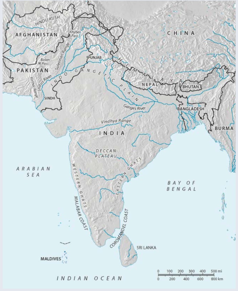
South Asia | Author: Larry Israel | Source: Original Work | License: CC BY-SA 4.0
The Indian subcontinent is where Indian civilization took shape. But that civilization was not created by one people, race, or ethnic group, and it doesn’t make sense to see India’s history as the history of one Indian people. Rather, the history of this region was shaped by a multitude of ethnic groups who spoke many different languages and lived and moved about on a diverse terrain suited to many different kinds of livelihood.
Large natural boundaries define the subcontinent. Mountain ranges ring the north, and bodies of water surround the rest. To the east lies the Bay of Bengal, to the south the Indian Ocean, and to the west the Arabian Sea. The largest mountain range is the Himalaya, which defines India’s northern and northeastern boundary. A subrange of the Himalaya—the Hindu Kush— sits at its western end, while a ridge running from north to south defines the eastern end, dividing India from China and mainland Southeast Asia. To the northwest, the Suleiman Range and Kirthar Range complete what might seem like impassable barriers. Yet, these ranges are punctuated by a few narrow passes that connect India to Central Asia and West Asia.
To the south of the mountain ranges lie the Indo-Gangetic Plain and the two great rivers of northern India that comprise it: the Indus River and the Ganges River. These rivers originate in the Himalaya and are regularly fed by snowmelt and monsoon rains. The Indus River, which is located in the northwest and drains into the Arabian Sea, can be divided into an upper and lower region. The region comprising the upper Indus and its many tributary rivers is called the Punjab, while the region surrounding the lower Indus is referred to as the Sindh. The Ganges River begins in the western Himalaya and flows southeast across northern India before draining into the Bay of Bengal. Because they could support large populations, the plains surrounding these river systems served as the heartland for India’s first major states and empires.
Peninsular India is also an important part of the story because over time great regional kingdoms will also emerge in the south. The peninsula is divided from northern India by the Vindhya Mountains, to the south of which lies the Deccan Plateau. This arid plateau is bordered by two coastal ranges— the Western Ghats and Eastern Ghats, beyond which are narrow coastal plains, the Malabar Coast and the Coromandel Coast. This nearly 4600 miles of coastline is important to India’s history because it linked fishing and trading communities to the Indian Ocean and, therefore, the rest of Afro-Eurasia. Sri Lanka is an island located about thirty kilometers southeast of the southernmost tip of India, and also served as an important conduit for trade and cultural contacts beyond India
India's First Major Civilization: The Indus Valley Civilization (2600 BCE-1700 BCE)
A century of archaeological work in India that began in 1920 not only revealed a lost civilization but also a massive one, surpassing in size other major early riverine civilizations of Afro-Eurasia, such as ancient Egypt and the Mesopotamian states. In an area spanning roughly a half million square miles, archaeologists have excavated thousands of settlements. These can be envisioned in a hierarchy based on size and sophistication. The top consists of five major cities of roughly 250 acres each. One of those is Harappa, and because it was excavated first the entire civilization was named Harappan Civilization. The bottom of the hierarchy consists of fifteen thousand smaller agricultural and craft villages of about 2.5 acres each, while between the top and bottom lie two tiers with several dozen towns ranging in size from 15 to 150 acres.
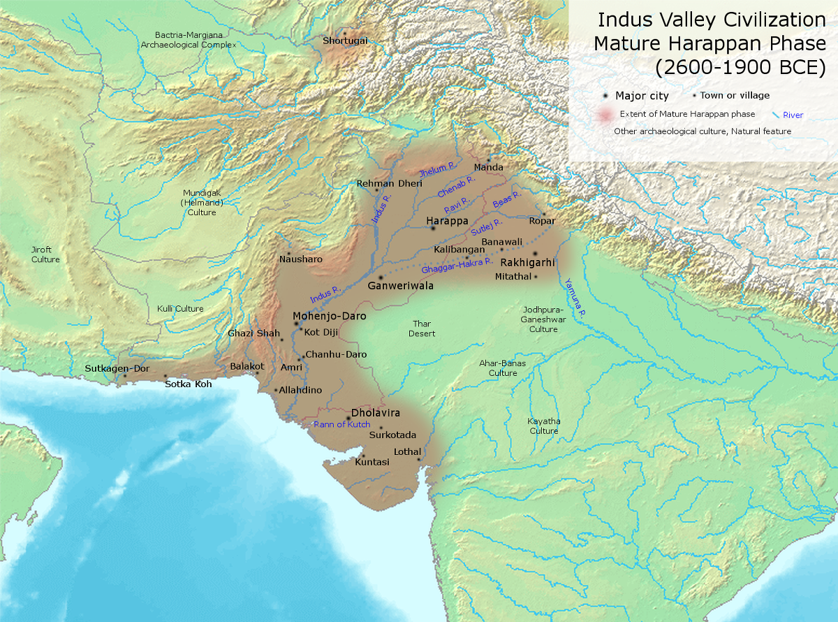
Indus Valley (Harappan) Civilization | Map of important Indus Valley (Harappan) Civilization cities and towns during its most developed period. | Author: User “Avantiputra7” | Source: Wikimedia Commons | License: CC BY-SA 3.0
Because the majority of these settlements were situated near the Indus River in the northwestern region of the subcontinent, this civilization is also called the Indus Valley Civilization.
As with ancient Egypt and Mesopotamia, archaeologists have been able to sketch out how this civilization evolved out of the simpler agricultural villages of the Neolithic period. On the subcontinent, farming and the domestication of animals began c. 7000 BCE, about two thousand years after they did in the Fertile Crescent. To the west of the Indus River, along the foothills of Baluchistan, the remains of numerous small villages have been found that date back to this time. One of these is Mehrgarh. Here, villagers lived in simple mud-brick structures, grew barley and wheat, and raised cattle, sheep, and goats.
Over the course of the next three thousand years, similar Neolithic communities sprang up not only in northwest India but also in many other locations on the subcontinent.

Archaeological sites dating to northwest India’s Neolithic period and the Indus Valley Civilization | Agricultural village societies first emerged to the west of the Indus and then spread to the Indus River and its many tributaries, as well as the Ghaggar-Hakra River (running parallel to and east of the Indus), which has since dried up. These provided the foundation for the emergence of towns and cities. | Author: User “Avantiputra7” | Source: Wikimedia Commons | License: CC BY-SA 3.0
But it was to the west of the Indus River and then throughout neighboring fertile plains and valleys of the Punjab and Sindh that we see the transition to a more complex, urban-based civilization. Excavations throughout this region show a pattern of development whereby settlements start looking more like towns than villages: ground plans become larger, include the foundations of houses and streets, and are conveniently located by the most fertile land or places for trade. Similar artifacts spread over larger areas show that the local communities building these towns were becoming linked together in trade networks. Archaeologists date this transitional period when India was on the verge of its first civilization from 5000 to 2600 BCE. The mature phase, with its full-blown cities, begins from 2600 BCE, roughly four centuries after the Sumerian city-states blossomed and Egypt was unified under one kingdom.
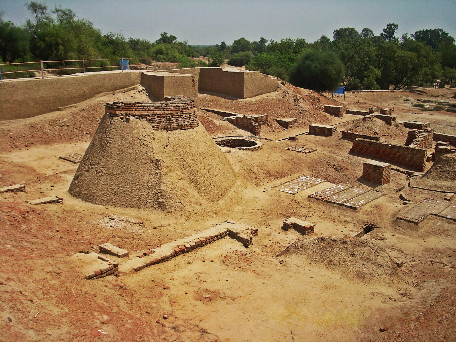
The ruins of Mohenjo-Daro and other Indus cities dating to this mature phase suggest a vibrant society thriving in competently planned and managed urban areas. Some of the principal purposes of these urban settlements included coordinating the distribution of local surplus resources, obtaining desired goods from more distant places, and turning raw materials into commodities for trade. Mohenjo-Daro, for instance, was located along the lower reaches of the Indus. That meant it was conveniently built amidst an abundance of resources: fertile floodplains for agriculture, pasture for grazing domesticated animals, and waters for fishing and fowling. The city itself consisted of several mounds—elevated areas upon which structures and roads were built. A larger mound served as a core, fortified area where public functions likely took place. It contained a wall and large buildings, including what archaeologists call a Great Bath and Great Hall. Other mounds were the location of the residential and commercial sectors of the city. Major avenues laid out on a grid created city blocks. Within a block, multistory dwellings opening up to interior courtyards were constructed out of mud bricks or bricks baked in kilns.
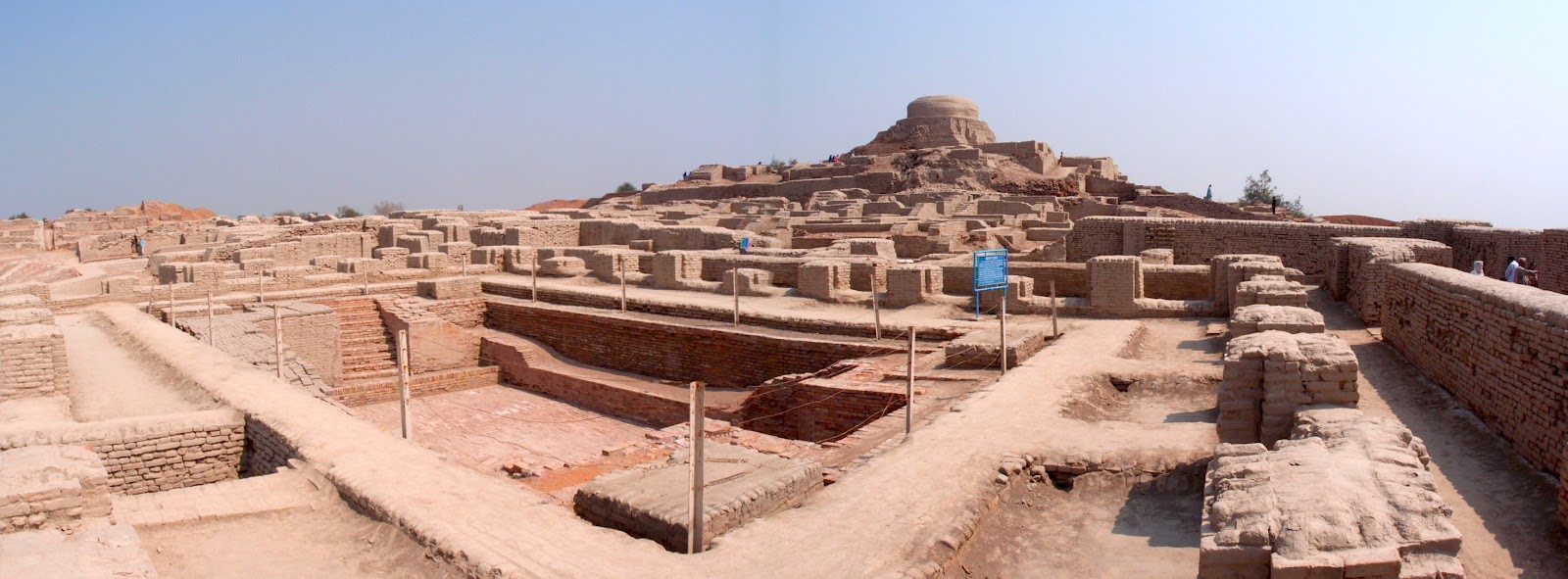
Great Bath at Mohenjo-Daro | View of the Great Bath at Mohenjo-Daro, an Indus Valley city located along the lower reaches of the Indus River. This section was part of the largest mound at the site. The higher structure in the rear is a Buddhist stupa dating to a later period in India’s history. | Author: Saqib Qayyum | Source: Wikimedia Commons | License: CC BY-SA 3.0
Particular attention was paid to public sanitation. Residences not only had private wells and baths, but also toilets drained by earthenware pipes that ushered the sewage into covered drains located under the streets.
Artifacts tell of city life. Farmers and pastoralists brought their grain and stock to the city for trade or to place it in warehouses managed by the authorities. Laborers dug the wells and collected trash from rectangular bins sitting beneath rubbish chutes. Craftsmen worked copper and tin into bronze tools, red ceramics, and manufactured jewelry and beads out of gold, copper, semi-precious stones, and ivory. Merchants traveling near and far carried raw materials and finished goods by bullock carts or boats to the dozens of towns and cities throughout the region.
Some goods also went to foreign lands. Harappan cities located along the coast of the Arabian Sea engaged in coastal shipping that brought goods as far as the Persian Gulf and the delta of the Tigris and Euphrates Rivers. In Mesopotamian city-states, Harappan seals and beads have been found, and Mesopotamian sources speak of a certain place called “Meluhha,” a land with ivory, gold, and lapis lazuli. That was the Indus Valley Civilization. Cities like Mohenjo-Daro were linked in networks of exchange extending in every direction.
But unlike ancient Egypt and Sumer, this civilization has not yet provided sources we can read, and this poses major problems of interpretation. True, over four thousand inscribed objects with at least four hundred different signs recurring in various frequencies have been found on clay, copper tablets, and small, square seals excavated primarily at the major cities. But the heroic efforts of philologists to decipher the language have failed to yield results. Thus, some historians call this civilization proto-historic, distinguishing it from both prehistoric cultures that have no writing and historic ones with written sources that we can read.

Seals from Indus Valley cities | These were made from red steatite and used to imprint the identity of owners on goods. | Author: User “MrABlair23” | Source: Wikimedia Commons | License: Public Domain
This proto-historical state of the evidence leaves many questions concerning Harappan people’s political organization and beliefs unanswered. On the one hand, much uniformity in the archaeological record across the region suggests coordination in planning—cities and towns were similarly designed, red bricks had the same dimensions, and weights were standardized. On the other hand, the ruins lack structures that can be clearly identified as palaces, temples, or large tombs. In other words, there is little evidence for either a central political authority ruling over an empire or for independent city-states. One intriguing artifact found in Mohenjo-Daro is a small sculpture of a bearded man made of soapstone. The dignified appearance suggests he may have been a priest or king, or even both. Perhaps he and other priests purified themselves in the Great Bath for ritual purposes. Yet, this is purely speculation, as the sculpture is unique. He may also have been a powerful landowner or wealthy merchant who met with others of a similar status in assemblies convened in the Great Hall of the citadel. Perhaps local assemblies of just such elites governed each city.

Indus Priest/King Statue | 17.5 cm tall sculpture found at Mohenjo-Daro. The dignified appearance and headband and cloak of this man suggest that he was an important political or religious leader in the city. | Author: Mamoon Mengal | Source: Wikimedia Commons | License: CC BY-SA 1.0
Religious beliefs are also difficult to determine. Again, some of the principal evidence consists of small artifacts such as figurines and the square seals. The seals were carved out of a soft stone called steatite and then red so they would harden. They contain images of animals and humans, typically with writing above. Mostly, they were used to imprint the identity of a merchant or authorities on goods. However, some of the images may have had religious significance. For example, hundreds of “unicorn seals” display images of a mythical animal that resembles a species of cattle. These cattle are usually placed over an object variously interpreted as a trough or altar. Perhaps these were symbols of deities or animals used for sacrificial rituals. Equally as interesting are the numerous female clay figurines. These may have been used for fertility rituals or to pay homage to a goddess.
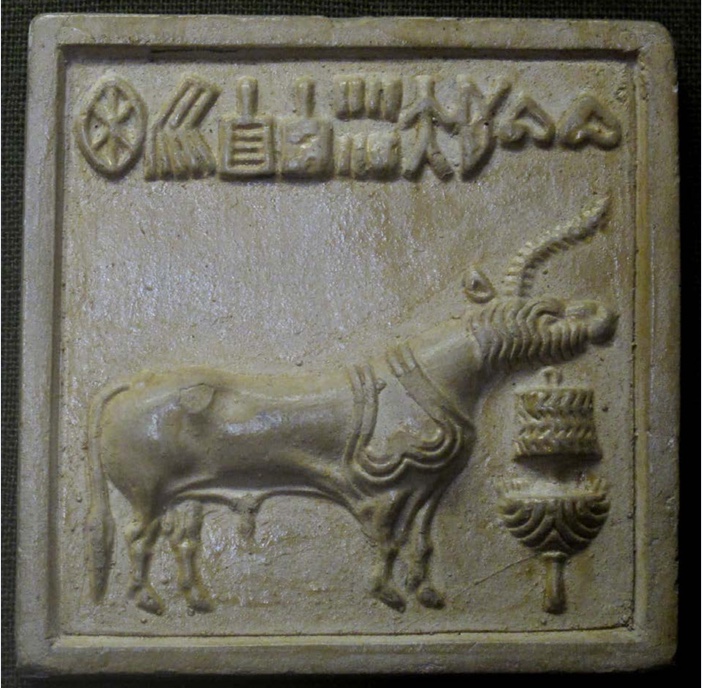
Unicorn Seal | Mold from a “unicorn seal” from Mohenjo-Daro depicting a mythical animal standing over an altar or trough, with writing above. | Author: User “Ismoon” | Source: Wikimedia Commons | License: CC0 1.0
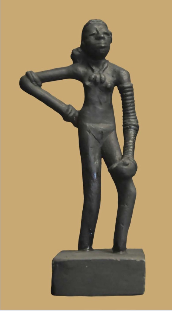
Dancing Girl of Mohenjo-daro | Author: Joe Ravi | Source: Wikimedia Commons | License: CC BY-SA 3.0
The decline of Harappan civilization set in from 1900 BCE and was complete two hundred years later. Stated simply, the towns and cities and their lively trade networks faded away, and the region reverted to rural conditions. Likely causes include geologic, climatic, and environmental factors. Movement by tectonic plates may have led to earthquakes, flooding, and shifts in the course of the Indus. Less rainfall and deforestation may have degraded the environment’s suitability for farming. All of these factors would have impacted the food supply. Consequently, urban areas and the civilization they supported were slowly starved out of existence.
The Geography of East Asia
China’s early historical development long predated Japan’s and Korea’s, which is why a chapter on East Asian history logically begins in the second millennium BCE with China’s first dynasty. However, today’s nation of China is much larger than China was in ancient times. In earlier times, the bulk of the Chinese population lived in China proper, by which we mean the historical heartland of ancient China.
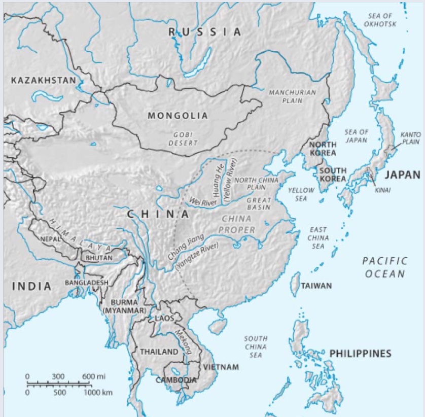
East Asia | Author: Larry Israel | Source: Original Work | License: CC BY-SA 4.0
To the east, China proper is bounded by the Yellow Sea, East China Sea, and South China Sea. To the south, it is bordered by the mountainous jungles of Southeast Asia. To the west and north, China is rimmed by a transitional frontier zone where land suited to agriculture gives way to mountains and plateau or vast expanses of steppe grasslands and desert. At times, the dynasties of China became actively involved in all of these neighboring areas, incorporating them directly into their expanding empires or indirectly as subordinate, tribute-paying states. Those areas include parts of the Korean Peninsula, Northeast China, Mongolia, Central Asia, and Vietnam.
Within China proper, two rivers were particularly important to the formation of agricultural communities that served as the building blocks of Chinese civilization. Those were the Yellow River and Yangzi River. The Yellow River meanders through the northern half of China, where a cool, dry climate is well-suited to wheat and millet farming. Beginning far to the west, this river meanders over dusty plateau, becomes muddied with silt, and then deposits this sediment along its middle and lower reaches. The plains surrounding these reaches are collectively referred to as the North China Plain. Historically, this was the heartland of Chinese civilization. However, the Yangzi River was just as important. Located in south China where the weather is relatively warmer and wetter, its long basin provided fertile soil for rice-paddy agriculture. Over time, the early dynasties expanded into and included the settled agricultural communities in this region.
Japan is an island country consisting of four main islands and many smaller ones located o the Pacific coast of the Asian continent. At 400,000 square kilometers, Japan is slightly smaller than California, although the terrain is more rugged. Because Japan is covered by mountains and traversed by numerous rivers, only fifteen percent of the land is suited to agriculture. Much of that was concentrated in two plains–the Kinai Plain and Kanto Plain–making them particularly important to Japan’s early history. Japan is also located along the Pacific Ring of Fire, where tectonic plates composing the earth’s crust frequently move and collide. That is why earthquakes and volcanic activity have been a constant threat to populations living on these islands.
The Korean Peninsula is the location of North and South Korea today. Prior to the twentieth century, however, it saw a long succession of Korean kingdoms. Extending roughly 1100 kilometers southward from the Asian landmass, the peninsula is bounded by seas to the east, west, and south, and de ned by the Yalu River to the north. Beyond that lies Northeast China which was only periodically included in the territory of Chinese empires. Consequently, because the peninsula lies between China to the north and west and Japan to the east, Korean dynasties have been deeply impacted by these states’ histories and cultures. Like Japan, Korea is also mountainous, although coastal areas and plains located to the west and south were well-suited to agriculture.
The countries of East Asia share in the region’s temperate climate and summer monsoon season. During the summer months, warm and moist air originating from the Pacific flows from southeast to northwest, while during the winter months cold and dry air originating from Central Asia moves in the opposite direction. Thus, those areas of East Asia located further to the east and south are generally warmer and wetter, and for longer periods of time. That made them well-suited to rice-paddy agriculture, and rice consequently became the primary cereal crop in southern China, the Korean peninsula, and the islands of Japan. While growing rice is labor intensive, this grain also offers high yields per unit of land, so it has supported population growth in these countries and, therefore, the formation of vibrant civilizations.
China from Neolithic Village Settlements to the Shang Kingdom

Neolithic cultures in China c. 4000 BCE | Note the location of Yangshao culture along the upper and middle reaches of the Yellow River, where nearly a thousand settlements have been identified by archaeologists. | Author: Lamassu Design | Source: Wikimedia Commons | License: CC BY-SA 3.0
Earlier sections of this chapter covered the development of the first major civilizations of Mesopotamia, Egypt, and India. In each case, rivers were particularly important to that process because they offered a stable supply of water for agriculture. Similarly, in China, the first major states emerged along China’s second longest river–the Yellow River. These states are the Xia [shee-ah] Dynasty (c. 1900 – 1600 BCE), Shang [shawng] Dynasty (1600 – 1046 BCE, See Chapter 3), and Zhou [joe] Dynasty (1045 – 256 BCE, see Chapter 4). Each of these kingdoms was ruled by a line of hereditary monarchs hailing from one lineage, which is why they are also referred to as dynasties.
Because written sources don’t become available until the Shang Dynasty, historians have relied heavily on the archaeological record to reconstruct the process by which these states arose. Looking back at the end of the Paleolithic era (c. 10000 BCE), East Asia was sparsely populated by bands of foragers living in temporary settlements. During the eighth millennium BCE, in China, some of these hunter-gatherers turned to domesticated cereals for a stable food supply and settled into villages so they could cultivate them. Thus, the Neolithic Age (8000 – 2000 BCE) commenced.
Over the course of those six millennia leading up to the Xia Dynasty, Neolithic communities became more diverse and complex. For instance, for the period 5000 – 3000 BCE, archaeologists have identified at least eight major regional Neolithic cultures located along rivers and coasts. They did so by examining pottery styles and village settlement patterns. One example is Yangshao culture, which was concentrated along the middle reaches of the Yellow River. Over one thousand sites left behind by millet-farming village communities have been discovered. Jiangzhai (c. 4000 BCE), for instance, was a moated village settlement that occupied roughly thirteen acres. It was composed of related lineages and tribal in organization.
During the third millennium BCE, Yangshao culture was gradually supplanted by Longshan culture (c. 3000 – 1900 BCE), which emerged further to the east, along the middle and lower reaches of the Yellow River. In 1928, when archaeologists excavated a site near the town after which Longshan was named, they found evidence for a culture that had laid the foundations for the kingdoms that emerged in the second millennium BCE, including the ruins of numerous walled towns with cemeteries outside. Their rammed-earth walls protected urban areas with public buildings, roads, and drainage systems. The cemetery’s arrangement suggests that people living in the towns were buried alongside clan members, but also that some members were wealthier and more powerful: while most graves had nothing but a skeleton, others contained numerous artifacts, such as pottery and jade.
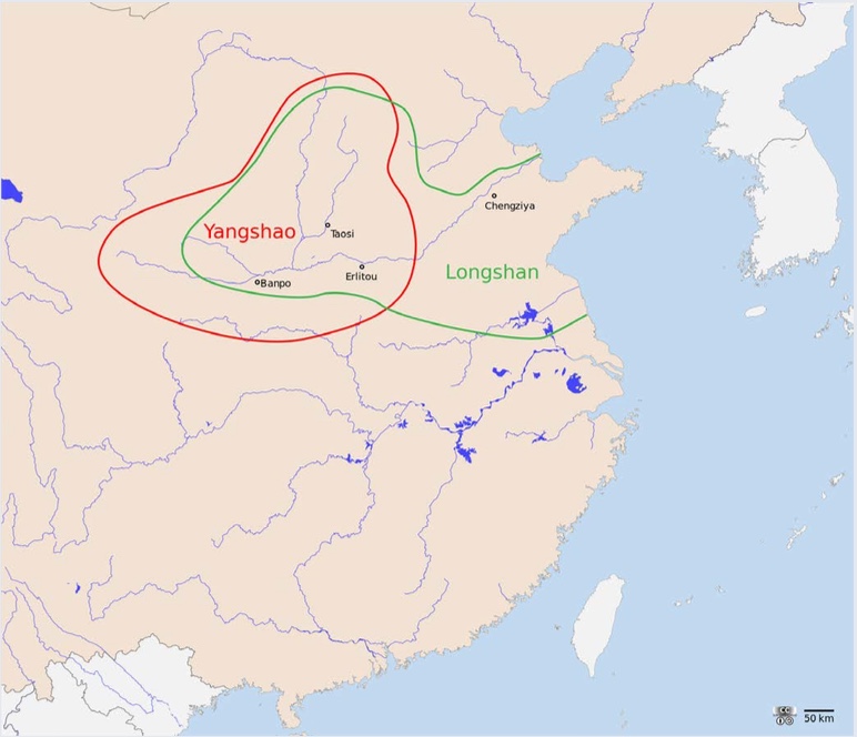
Location of Yangshao culture (5000-3000 BCE) and Longshan culture (3000-1900 BCE) | Note that they overlapped, but also that Longshan culture came later and eventually supplanted Yangshao culture. | Author: Lamassu Design | Source: Wikimedia Commons | License: CC BY-SA 3.0
Based on this evidence, archaeologists have concluded that, during the third millennium BCE, population grew and some of it shifted from villages to walled towns. These walled towns developed into political and economic centers exercising control over and serving as protection for surrounding communities. Individuals with more elaborate graves were likely political and religious leaders, and served as chieftains. Hence, numerous competing chiefdoms emerged, providing the foundation for more powerful kingdoms to follow.
Ancient Chinese histories identify the first major kingdom as the Xia Dynasty (c. 1900 – 1600 BCE). However, these were written many centuries after the kingdom about which they speak and, lacking written evidence from the dynasty itself, specialists have been unable to definitively establish its location. Nevertheless, most agree that the Xia capital was located along the Yellow River at Erlitou [are-lee-toe]. At its peak of activity from 1900 – 1600 BCE, this town looks like something more complex than a chiefdom. Erlitou included a central, walled palace complex, workshops for the production of bronze and pottery, and elite burials containing bronze weapons and jade, suggesting a socially stratified, Bronze Age civilization and kingdom. That is why many historians identify it as the capital of Xia Dynasty.
Works Consulted and Further Reading
Civilizations
Bellows, Sierra. “The Trouble with Civilization,” UVA Magazine (Fall 2010)
Brown, Cynthia Stokes. “What is a Civilization, Anyway?” World History Connected (October 2009)
Mesopotamia
International World History Project. “The Akkadians.”
Khan Academy. “Ziggurat of Ur.”
Kilmer, Anne. “The Musical Instruments from Ur and Ancient Mesopotamian Music.” Expedition. The Penn Museum. 40, 2 (1998): 12-18.
Kramer, Samuel. The Sumerians: Their History, Culture, and Character. Chicago: Chicago University Press, 1963.
Leick, Gwendolyn. Mesopotamia: The Invention of the City. London: Penguin Books, 2004.
Mitchell, William. “The Hydraulic Hypothesis: A Reappraisal.” Current Anthropology. Vol. 15. No. 5. (Dec. 1973): 532-534.
Postgate, J.N. Early Mesopotamia: Society and Economy at the Dawn of History. London: Routledge, 1994.
Spar, Ira. “Gilgamesh.” In Heinbrunn Timeline of Art History. New York: The Metropolitan Museum of Art, 2000. (April 2009).
University of Pennsylvania Museum of Archaeology and Anthropology. “Iraq’s Ancient Past: Rediscovering Ur’s Royal Cemetery.”
Ancient Egypt
Australian Museum. “The Underworld and the Afterlife in Ancient Egypt.” (Australian Museum, 2015).
David, Rosalie. The Pyramid Builders of Ancient Egypt: A Modern Investigation of Pharaoh’s Workforce. New York: Routledge, 1997.
Dollinger, Andre. “Slavery in Ancient Egypt.” (February 2011).
Hierakonoplis Expedition, Hierakpopolis-online.
Johnson, Janet. “Women’s Legal Rights in Ancient Egypt.” Fathom Archive, Digital Collections. University of Chicago Library: 2002.
McDowell, A.G. Village Life in Ancient Egypt: Laundry Lists and Love Songs. Oxford: Oxford University Press, 1999.
Pinch, Geraldine. Egyptian Mythology: A Guide to the Gods, Goddesses, and Traditions of Ancient Egypt. Oxford: Oxford University Press, 2004.
Shaw, Ian. The Oxford History of Ancient Egypt. Oxford: Oxford University Press, 2004.
Shillington, Kevin. History of Africa. 2nd ed. Oxford: Macmillan Education, 2005.
Smith, Jeffrey. “The Narmer Palette,” Yale 2013 PIER Summer Institutes.
Teeter, Emily. Religion and Ritual in Ancient Egypt. Cambridge: Cambridge University Press, 2011.
Tyldesley, Joyce. Daughters of Isis:Women in Ancient Egypt. New York: Penguin History, 1995.
South Asia
Avari, Burjor. India, The Ancient Past: A History of the Indian Sub-Continent from c. 7000 BC to AD 1200. Routledge: New York and Oxon, 2007.
Keay, John. India: A History. New York: Grove Press, 2000.
Khan, Omar. “Harappa.com,” accessed October 15, 2014.
Singh, Upinder. A History of Ancient and Medieval India: From the Stone Age to the 12th Century. New York: Pearson Education, 2008.
Thapar, Romila. Early India: From the Origins to AD 1300. Berkeley: University of California Press, 2002.
Trautmann, Thomas R. India: Brief History of a Civilization. Oxford: Oxford University Press, 2011.
East Asia
Ebrey, Patricia, James B. Palais, and Anne Walthall. East Asia: A Cultural, Social, and Political History. Boston: Houghton Mifflin Company 2006.
Li Feng. Early China: A Social and Cultural History. Cambridge University Press, 2013.
Temple, Robert. The Genius of China: 3,000 years of Science, Discovery and Invention. Rochester: Inner Traditions, 2007.
Links to Primary Sources
Mesopotamia
aThe Epic of Gilgamesh. Nancy Sandars (trans.). New York: Penguin Books, 1960.
“The Flood.” Excerpted from S. Dalley. Myths from Mesopotamia. New York: Oxford University Press, 1991.
“Hymn to the Nile, c. 2100 BCE.”Ancient History Sourcebook. Fordham University.
South Asia
Harappan Civilization Seals and other Artifacts
From Berger, Eugene; Israel, George; Miller, Charlotte; Parkinson, Brian; Reeves, Andrew; and Williams, Nadejda, "World History: Cultures, States, and Societies to 1500" (2016). History Open Textbooks. Book 2. http://oer.galileo.usg.edu/history-textbooks/2
CC BY-SA
This work is licensed under a Creative Commons Attribution-ShareAlike 4.0 International License.