Using GIS and Maps to Teach Mathematics: Measurement, Numbers, and Shapes
Using GIS and Maps to Teach Mathematics: Measurement, Numbers, and Shapes
In this lesson, you will use an interactive web map made with a Geographic Information System (GIS) to learn and practice mathematics skills, such as measurement, numbers, and shapes. You will solve real problems and explore the world at the same time.
Map URL: http://arcg.is/2ejLml8
Click the map URL above to launch the map. It should look like the map below.
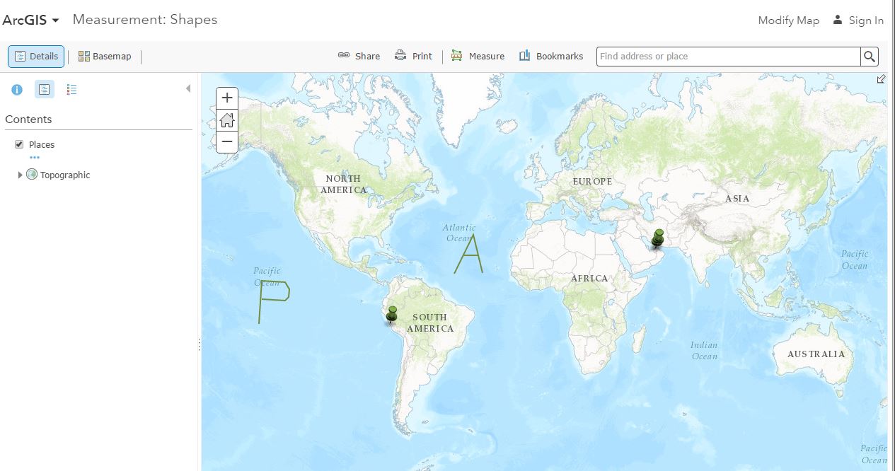
This is a screenshot of an interactive world map that will be used with this lesson.
1. What do the pushpins represent? [The airports at Lima and Dubai].
2. Let’s say you had to pilot an airplane from Lima to Dubai. Use the Measure tool and select the ruler
symbol to measure the distance between the pushpin at Abu Dhabi and the pushpin at Lima, Peru. The distance will be shown as a blue line. What is the distance between these two locations, in kilometers? [Approximately 14,076 km].
? The line you draw between the two locations is a curve rather than a straight line because the Earth is a sphere, but it is represented here by a flat map. The line represents the shortest distance between the two points and is same as a line you would draw on a globe connecting the two points.
3. If you travel at the typical speed of a Boeing 747 jet, at 800 km/h, how long will it take for you to travel from Lima to Dubai, in hours? Round to nearest 1/10th of an hour. [14,076/800 = 17.59, or 17.6 hours].
4. Let’s say that due to a volcanic eruption in South America, you now must fly the other way around the world—instead of from west to east across the Atlantic Ocean (A), from east to west, across the Pacific (P). Click once on Lima, once in Australia (to refuel your plane!), and twice on Dubai to end. What is the distance? [25,905 km].
5. How much farther is the distance across the Pacific Ocean between Lima and Dubai versus the distance across the Atlantic Ocean? [25,905 / 14076=1.84 times longer].
6. How long will your flight now be? [25905/800=32.38 hours]. Now you must also cross the International Date Line, losing 9 hours. Add 9 hours to your time and obtain the new total: [25905/800 = 32.38 hours+9 hrs = 40.38 hrs.]. Do you arrive in Dubai the same day as you left Lima or one day later? [One day later].
7. Now let’s say that once you land at Dubai, you want to journey to the Abu Dhabi International Airport. Use Bookmarks and Abu Dhabi International Airport. Select Basemaps and change the base map to Imagery with Labels. Zoom in to see more detail. Find the longest runway at the airport—the one with the pushpin at one end. This runway is marked with the number “13” at one end and a “31” at the other end.
8. What is the distance in kilometers of the paved portion of this runway from end to end? [4.05 km]. What is the distance in meters of this longest runway from end to end? [4050 m]. Explain how to convert measurements from kilometers to meters. [Multiply kilometers by 1000 to obtain meters].
Explain
9. Change the base map to Topographic. > Bookmark: “Abu Dhabi Area” What shape is the tan feature? [square].
10. Measure each side, in kilometers, with the measure tool. How long is each side? Is the shape a perfect square? What is the perimeter of the shape? [Length of each side=4 km. The shape is a perfect square. Perimeter=16 km].
11. Given the length of each side, how much area would the shape have if it were a perfect square? Why? Be sure to specify the (square) units that you are using. [It should contain 16 sq km: length x width = 4 x 4 = 16 sq km].
12. Now, test your hypothesis by using the Measure Area tool and measure the total area of the shape. What is the total area? Does the total area match the value that you predicted above? [The total area of the polygon is 16 square kilometers. The total area should match the predicted value (unless student did not predict a square)].
Elaborate
Change the base map to National Geographic. Use Bookmarks and select United Arab Emirates (UAE).
13. Use the Measure Polygon tool, draw a boundary around the UAE, making sure that you include some water in your polygon (as shown below). What is the total area of the UAE as you have calculated in square kilometers? What is one reason why your answer may not match the answer of your classmates? [Answers will vary slightly but should be around 112,000 square kilometers. One reason why student answers may not all be the same is inaccurate tracing around the boundaries, or including a greater or lesser amount of the water.]
14. Round your measurement to the nearest hundreds of square kilometers. [Answers will vary depending on the answer to the previous question, but should be about 112,000 square kilometers]. Convert your area measurement to square meters. [Because 1 km = 1000 x 1000 = 1,000,000 sq m, the answer in square meters is 112,000 x 1,000,000 = 112,000,000,000, or 112 billion square meters.]
Evaluate
15. Use the search box to find your community and your school building; zoom to the most detailed scale possible. Use the measurement tool to measure the perimeter of your main school building shown on the satellite image in meters. [Answers will vary]. Describe the shape of your school building. What rooms in the building “stick out” from other parts, and what are the functions of these rooms? [Answers will vary].
16. Measure the perimeter of your school building by walking around it with a tape measure or another device. What is its perimeter as you measured it (in meters)? [Answers will vary].
17. What is the difference between the perimeter as calculated from the satellite image vs. the one you measured by hand? [Answers will vary]. Why are the two measurements not exactly the same? [The hand-measured perimeter is likely longer than the image measurement, because extra details are measured as one walks around the school].
--------------------------
Technical Notes
This lesson uses ArcGIS Online - www.arcgis.com. With this and with manyother lessons based on ArcGIS Online, no log in is required. For more capabilities, a log in is required.
The Measure tool can measure distances, areas, and return a latitude-longitude position.
Bookmarks help you quickly navigate to a locationi.
The base map button allows you to choose among a variety of basemaps, all scalable from global to local.