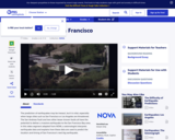
In this video segment adapted from NOVA, a geologist digs a trench …
In this video segment adapted from NOVA, a geologist digs a trench along the San Andreas Fault to reveal three thousand years of earthquake history. Information from the layers of sediment may help geologists to predict earthquakes.
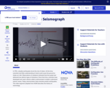
This video segment adapted from NOVA uses historical illustrations, photographs, and animations …
This video segment adapted from NOVA uses historical illustrations, photographs, and animations to explain how seismographs work, the difference between P and S waves, and the Richter scale.
This activity uses the free software 'Seismic Eruption' to visualize seismicity and …
This activity uses the free software 'Seismic Eruption' to visualize seismicity and volcanic activity in space and time and to explore the relationship of earthquakes and volcanic activiy to plate tectonics. Students run simulations on the Pacific coasts of South America and California and the mid-oceanic ridge in the Atlantic Ocean, answer questions, and construct a cross-section. A link to download the software is provided.
In this module, students are asked to devise a way of graphically …
In this module, students are asked to devise a way of graphically plotting the density variations with depth in the Earth.
(Note: this resource was added to OER Commons as part of a batch upload of over 2,200 records. If you notice an issue with the quality of the metadata, please let us know by using the 'report' button and we will flag it for consideration.)
This module explores the combination of densities and shell thicknesses that produce …
This module explores the combination of densities and shell thicknesses that produce an aggregate density of the Earth of 5.5 g/cm3.
(Note: this resource was added to OER Commons as part of a batch upload of over 2,200 records. If you notice an issue with the quality of the metadata, please let us know by using the 'report' button and we will flag it for consideration.)
Working in groups, students learn to navigate a virtual globe, read geophysical …
Working in groups, students learn to navigate a virtual globe, read geophysical data, and assess plate tectonic models. They prepare by studying about plate tectonics from their notes or from the text, and then apply that knowledge to real tectonic settings on the virtual globe. Students drag 3D models out of the subsurface and compare real data to model interpretations. They can also substitute their own sketches for our images.
(Note: this resource was added to OER Commons as part of a batch upload of over 2,200 records. If you notice an issue with the quality of the metadata, please let us know by using the 'report' button and we will flag it for consideration.)
A great variety of processes affect the surface of the Earth. Topics …
A great variety of processes affect the surface of the Earth. Topics to be covered are production and movement of surficial materials; soils and soil erosion; precipitation; streams and lakes; groundwater flow; glaciers and their deposits. The course combines aspects of geology, climatology, hydrology, and soil science to present a coherent introduction to the surface of the Earth, with emphasis on both fundamental concepts and practical applications, as a basis for understanding and intelligent management of the Earth's physical and chemical environment.
This course is designed to be a survey of the various subdisciplines …
This course is designed to be a survey of the various subdisciplines of geophysics (geodesy, gravity, geomagnetism, seismology, and geodynamics) and how they might relate to or be relevant for other planets. No prior background in Earth sciences is assumed, but students should be comfortable with vector calculus, classical mechanics, and potential field theory.
Evolution of Physical Oceanography was created to mark the career of Henry …
Evolution of Physical Oceanography was created to mark the career of Henry M. Stommel, the leading physical oceanographer of the 20th Century and a longtime MIT faculty member. The authors of the different chapters were asked to describe the evolution of their subject over the history of physical oceanography, and to provide a survey of the state-of-the-art of their subject as of 1980. Many of the chapters in this textbook are still up-to-date descriptions of active scientific fields, and all of them are important historical records. This textbook is made available courtesy of The MIT Press.
This assignment is intended to have students use the map reading skills …
This assignment is intended to have students use the map reading skills they have learned in previous labs and their understanding of the lower crust and upper mantle derived from classroom lectures and demonstrations to develop a three-dimensional picture the Southern Canadian Cordillera. I try to incorporate the notion of temporal change by asking students to describe the region at different times in the past and to speculate what the region would look like if certain tectonic events happened in the future.
(Note: this resource was added to OER Commons as part of a batch upload of over 2,200 records. If you notice an issue with the quality of the metadata, please let us know by using the 'report' button and we will flag it for consideration.)
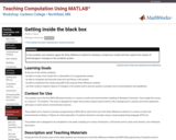
This activity introduces students to the finite difference solution of the hill-slope …
This activity introduces students to the finite difference solution of the hill-slope diffusion PDE. The students derive partial derivatives from Taylor Series expansions of the 2D topography function z(x,t). After deriving the finite difference solution to this PDE, students implement this solution in MATLAB to model hillslope evolution in time using constant material properties and time steps.
(Note: this resource was added to OER Commons as part of a batch upload of over 2,200 records. If you notice an issue with the quality of the metadata, please let us know by using the 'report' button and we will flag it for consideration.)
In this module, students examine Archimede's Principle in general and as it …
In this module, students examine Archimede's Principle in general and as it applies to Isostacy.
(Note: this resource was added to OER Commons as part of a batch upload of over 2,200 records. If you notice an issue with the quality of the metadata, please let us know by using the 'report' button and we will flag it for consideration.)
Students are asked to numerically and then analytically determine the relations governing …
Students are asked to numerically and then analytically determine the relations governing the depth of compensation.
(Note: this resource was added to OER Commons as part of a batch upload of over 2,200 records. If you notice an issue with the quality of the metadata, please let us know by using the 'report' button and we will flag it for consideration.)
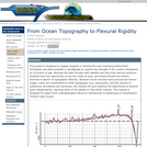
Students will use the available bathymetric datasets to test the utility of …
Students will use the available bathymetric datasets to test the utility of a flexural rigidity model of oceanic crust.
(Note: this resource was added to OER Commons as part of a batch upload of over 2,200 records. If you notice an issue with the quality of the metadata, please let us know by using the 'report' button and we will flag it for consideration.)
This is a freshman advising seminar. The professor of a FAS is …
This is a freshman advising seminar. The professor of a FAS is the first year advisor to the (no more than 8) students in the seminar. The use of Global Positioning System (GPS) in a wide variety of applications has exploded in the last few years. In this seminar we explore how positions on the Earth were determined before GPS; how GPS itself works and the range of applications in which GPS is now a critical element. This seminar is followed by a UROP research project in the spring semester where results from precise GPS measurements will be analyzed and displayed on the Web.
This course examines diagnostic studies of the Earth's atmosphere and discusses their …
This course examines diagnostic studies of the Earth's atmosphere and discusses their implications for the theory of the structure and general circulation of the Earth's atmosphere. It includes some discussion of the validation and use of general circulation models as atmospheric analogs.
This website contains a geologic map of the Island Park, Idaho area. …
This website contains a geologic map of the Island Park, Idaho area. The map shows rocks, deposits, faults, calderas, flows, and other geologic features of interest.
In this problem set students apply the finite difference method to develop …
In this problem set students apply the finite difference method to develop a simple box model and then explore the impact of anthropogenic changes to the modeled system.
(Note: this resource was added to OER Commons as part of a batch upload of over 2,200 records. If you notice an issue with the quality of the metadata, please let us know by using the 'report' button and we will flag it for consideration.)
No restrictions on your remixing, redistributing, or making derivative works. Give credit to the author, as required.
Your remixing, redistributing, or making derivatives works comes with some restrictions, including how it is shared.
Your redistributing comes with some restrictions. Do not remix or make derivative works.
Most restrictive license type. Prohibits most uses, sharing, and any changes.
Copyrighted materials, available under Fair Use and the TEACH Act for US-based educators, or other custom arrangements. Go to the resource provider to see their individual restrictions.