Word Count: 55656 (Note: This resource's metadata has been created automatically by …
Word Count: 55656
(Note: This resource's metadata has been created automatically by reformatting and/or combining the information that the author initially provided as part of a bulk import process.)
What factors lead to a natural disaster? What causes a famine? Why …
What factors lead to a natural disaster? What causes a famine? Why do cities flood? According to a recent article in The Atlantic, Houston's flooding during the 2017 Hurricane Harvey was primarily caused by impervious pavement which prevents the absorption of water into the land. This example illustrates how nature and society are interlinked, which is the main focus of Geography 30, Penn State's introductory course to nature-society geography. In addition to examining the linkages between human development and natural hazards, this course will also explore human society's connection to food systems, climate change, urbanization and biodiversity. The course will also cover topics of ethics and decision making in order to help students evaluate the tradeoffs of these interconnections. \The Atlantic\" needs to be made into a link pointing to this: https://www.theatlantic.com/technology/archive/2017/08/why-cities-flood/538251/"
DESCRIPTION Introduces students to the theory and methods of remote sensing through use of satellite imagery. Practical exercises involve use of SPOT, LANDSAT and Quickbird images with ArcGIS/Imagine Analysis software. Digital analysis is discussed and performed including preprocessing, image classification and image evaluation. Intended for students enrolled in the second year of GIS or UAS programs, or similar academic preparation (see program director for details).
LEARNING OUTCOMES 1. Demonstrate knowledge and apply skills essential to the discipline. 2. Apply GIS skills necessary to provide geospatial and thematic data. 3. Apply critical thinking and problem solving skill that reflect best practice. 4. Coordinate and manage the delivery of reliable, valid, GIS data including analysis and specialized user needs products. 5. Communicate effectively and appropriately within a professional setting in both written and oral form.
This unit explores school geography, focusing upon how geography is currently being …
This unit explores school geography, focusing upon how geography is currently being taught and understood. While studying this unit you will read about the significance of geography as a subject, looking at differing views as to exactly which disciplines make up geography. The unit also includes a lesson plan and a look at definitions of geography as a medium of education.
Latin America covers part of North America, South America, and the West …
Latin America covers part of North America, South America, and the West Indies. It stretches from lifeless Atacama desert to rugged highlands and Alpine glaciers of the Andes mountains. The fertile plains of the Pampas are one of the world's richest agricultural regions. The Amazon Basin is the largest and wettest lowland in the world. Culturally, Latin America is a great mixture of European, indigenous and African cultures.
In this course, we will examine the peoples and places of Latin America from a geographical perspective. We will explore the geographical dimensions of economic, cultural, political, and physical forces influencing Latin America as a region. We will have a mixture of thematic and regional approaches to study the concepts and look into various physical and historical processes that have shaped dynamic and diverse cultural landscapes. We will study contemporary environmental and developmental issues, trends in migration, agricultural change, and globalization to understand Latin America's position in the global economy.
COURSE LEVEL LEARNING OUTCOMES
Define Latin America as a world region. Identify the main physical and cultural features and characteristics of Latin America. Interpret maps, graphs, and visuals as tools for analyzing the distribution patterns of phenomena and understanding their importance in the context of Latin America. Explain the impacts of European colonialism in Latin America. Evaluate how changing cultural, social, political, and economic characteristics of Latin American countries influence internal strife and external intervention. Explain the complexities that contributed to the social inequality, political conflict, and environmental concerns prevalent in some Latin American countries. Discuss the changing political and economic relationships between the United States and countries in Latin America.
This project involved students in in-depth research, thus understanding, of the geological …
This project involved students in in-depth research, thus understanding, of the geological setting of Bozeman. Teams defined the scope of their investigations (with faculty oversight) and delegated tasks to build a knowledge base. This understanding lead to the outreach component -- a poster session to present this knowledge to the campus and broader community. The poster contents were submitted in a digital form as well, with the long-term goal the compilation of a printed poster (suitable for the Chamber of Commerce, for example, to distribute) analogous to those produced for the Geoscape Canada project. As a hook, I would plan to do a brief pretest on the region involving WHAT students know about the region beforehand and WHY they might need to know. Sample questions: Content: How deep would one have to dig or drill to find groundwater under downtown Bozeman Under the airport?? Significance: Which of the following processes/hazards are made worse by groundwater close to the surface? Earthquakes, Landslides... An advantage to such a pretest would be an end-of-semester reflection exercise including the same test as a post-test.
(Note: this resource was added to OER Commons as part of a batch upload of over 2,200 records. If you notice an issue with the quality of the metadata, please let us know by using the 'report' button and we will flag it for consideration.)
Geographic Intelligence (GEOINT) is more than people working with computers in a …
Geographic Intelligence (GEOINT) is more than people working with computers in a secure intelligence facility. Join us for this exciting journey to learn about GEOINT's application in business, law enforcement, and defense. Advances in satellites, GPS, unmanned aerial systems, wireless communications, handheld computing, and the ability to automate laborious map analysis processes has transformed what used to be called geographic intelligence, or GEOINT, and the nature of the insights provided to managers and leaders. We have gone from mountains of hardcopy maps to amazing automated systems that provide previously unavailable understanding. GEOINT combines geographic information science and technologies with an analytic tradecraft. You will experience the value of GEOINT. We welcome you to the Revolution.
This course gives an introduction to German language and culture. The focus …
This course gives an introduction to German language and culture. The focus is on acquisition of vocabulary and grammatical concepts through active communication. Audio, video, and printed materials provide direct exposure to authentic German language and culture. A self-paced language lab program is fully coordinated with the textbook/workbook. The first semester covers the development of effective basic communication skills.
Today, over 115 million children have never set foot inside a school. …
Today, over 115 million children have never set foot inside a school. The fact is that for children living in developing countries, the dream of a first day of school is yet to be realized. The daily realities of poverty, political instability, regional conflict, geography, and cultural or traditional values all play a role to varying degrees -- and the issue of gender disparity makes this fact even more staggering. Full and equal access to education (Article 26) as outlined in the 'Universal Declaration of Human Rights' and 'The Convention on the Rights of the Child' (Articles 2,3,28, and 29), has clearly been out of the reach of poor children -- and even more so in the case of girls. Nearly two-thirds of children who are denied a primary education are girls. In the least developed countries, nearly twice as many adult women than men are illiterate. (Source: UNFPA http://www.unfpa.org/icpd/10/icpd_ed.htm) If you happen to be a female, you are less likely to have access to a quality primary education and beyond -- contributing to the feminization of global poverty. Yet, there is hope despite this current state of affairs. 189 nations have pledged to meet 8 major Millennium Development Goals (MDGs) by 2015. In doing so, nations hope to improve the social and economic development of all peoples. Included in these goals are those that address education and gender disparity: MDG 2: Achieve universal and primary education. MDG 3: Promote gender equality and empower women. Through the activities outlined in this lesson, students will become familiar with the current barriers standing in the way of educational opportunity -- especially for girls. They will watch clips from the WIDE ANGLE film 'Time for School' (2003) to understand the sense of urgency surrounding this issue, the potential benefits that can result from educating girls, and the ways that local communities are trying to address these problems. Note: This lesson focuses on MDG 2 and MDG 3. An introduction to the overall goals of the Millennium Project should be presented prior to this particular lesson.
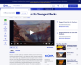
This video segment adapted from NOVA features the youngest rock formations in …
This video segment adapted from NOVA features the youngest rock formations in the Grand Canyon, lava dams, and how they are subject to the eroding power of water.
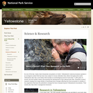
The Greater Yellowstone Science Learning Center is a portal to information about …
The Greater Yellowstone Science Learning Center is a portal to information about the natural and cultural resources of Yellowstone and Grand Teton (including John D. Rockefeller, Jr. Memorial Parkway) national parks and Bighorn Canyon National Recreation Area. By reporting on what has been learned from research and monitoring in these parks, we hope to increase public awareness of new findings and encourage studies that will help guide park management decisions. The National Park Service has set up Research Learning Centers as public-private partnerships that promote the sharing of scientific knowledge about the parks.
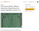
Release of the film Green Book (2018) inspired renewed interest in the …
Release of the film Green Book (2018) inspired renewed interest in the experiences of African Americans when traveling in the United States during the 20th century. This inquiry-based lesson combines individual investigations with whole or small group analysis of primary sources and visual media to investigate the compelling question: How have the intersections of race and place impacted U.S. history and culture?
This article provides links to hands-on science activities that could be used …
This article provides links to hands-on science activities that could be used in an festival or informal learning event. National standards correlations are provided.
This activity reveals a snapshot of declared church affiliation in 1870. It …
This activity reveals a snapshot of declared church affiliation in 1870. It provides historical inquiry questions for students to evaluate the chart. The questions are divided into the following topics: observe, reflect, question, and analyze. This activity may be used to introduce and engage students in the process of historical inquiry and/or to process and reflect about the influence of church affiliation in the United States.
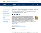
This activity allows students to compare and contrast U.S. occupational categories and …
This activity allows students to compare and contrast U.S. occupational categories and school attendance in 1870 across genders and states. It provides questions for students to practice historical inquiry and evaluate the chart. The questions are divided into the following topics: observe, reflect, question, and analyze. This activity may be used to introduce and engage students in the process of historical inquiry and/or to supplement study of workforce participation in the United States.
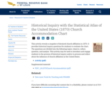
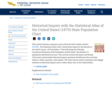
This activity features a primary source from the Fed's online archive, FRASER. …
This activity features a primary source from the Fed's online archive, FRASER. The activity allows students to see maps depicting the best data available for the U.S. population at the time and to practice historical inquiry skills. The activity may be used as a way to introduce early migration or as a supplemental activity.
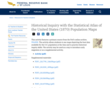
This activity features a primary source from the Fed's online archive, FRASER. …
This activity features a primary source from the Fed's online archive, FRASER. The Statistical Atlas of the United States Based on the Results of the Ninth Census, 1870 includes a "Chart Showing the Principal Constituent Elements of the Population of Each State" that details U.S. population distribution by race. This activity reviews the layout and format of the chart and provides historical inquiry questions divided into four sections: observe, reflect, question, and analyze. The chart may be used to introduce and engage students in historical inquiry and to reflect about race in the United States.
This course introduces students to modern world history and geography. It provides …
This course introduces students to modern world history and geography. It provides an opportunity for students to learn and further develop foundational research and writing skills by incorporating practice into every class session. Early in the course, students select a country to study, then all research and writing activities are focused on that country. It also utilizes the United Nations Sustainable Development Goals to help students explore their country.The course utilizes openly licensed textbooks and publicly available materials as course materials.This survey course is intended for freshmen and sophomore-level students who are interested in exploring historical, political and social contexts beyond their own. Students will have ample opportunities to practice foundational skills including writing, research, source citation, critical thinking and public speaking.It was originally taught over 13 weeks as part of a Fulbright US Scholar grant in the International College at Tunghai University in Taichung Taiwan. It was developed with support from the Open Education for a Better World Program.
During the mid-19th century, cotton was king. Historian Wayne Dowdy explained how …
During the mid-19th century, cotton was king. Historian Wayne Dowdy explained how vital this crop was the Memphis economy and its continuing effects on race and culture in the city.
No restrictions on your remixing, redistributing, or making derivative works. Give credit to the author, as required.
Your remixing, redistributing, or making derivatives works comes with some restrictions, including how it is shared.
Your redistributing comes with some restrictions. Do not remix or make derivative works.
Most restrictive license type. Prohibits most uses, sharing, and any changes.
Copyrighted materials, available under Fair Use and the TEACH Act for US-based educators, or other custom arrangements. Go to the resource provider to see their individual restrictions.