Read the Fine Print
Educational Use
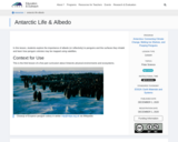
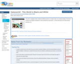
This lesson is a lab in which students use thermometers, white and dark paper, and lamps to measure differences in albedo between the light and dark materials. Connections are made to albedo in Antarctica.
- Subject:
- Applied Science
- Career and Technical Education
- Environmental Science
- Environmental Studies
- Physical Science
- Physics
- Material Type:
- Activity/Lab
- Provider:
- CLEAN: Climate Literacy and Energy Awareness Network
- Provider Set:
- CLEAN: Climate Literacy and Energy Awareness Network
- Author:
- American Museum of Natural History and Rice University
- Date Added:
- 08/25/2011