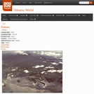
This page from the Volcano World website contains a summary account of …
This page from the Volcano World website contains a summary account of the 1959 eruption at Kilauea Iki which is illustrated by photographs and videos.
This video adapted from the Valdez Museum & Historical Archive, explores what …
This video adapted from the Valdez Museum & Historical Archive, explores what happened during the Great Alaska Earthquake of 1964 through original footage, first-person accounts, and animations illustrating plate tectonics.
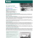
This site describes how and when 100-year floods occur. It states that …
This site describes how and when 100-year floods occur. It states that flood designations are based on statistical averages, not on the number of years between big floods. It also suggests that it would make more sense to refer to 100-year floods as 1-in-100 chance floods. This resource is a United States Geological Survey (USGS) Fact Sheet. It can be used in teaching quantitative skills.
This exercise uses the example of the March 28, 2014 M5.1 La …
This exercise uses the example of the March 28, 2014 M5.1 La Habra earthquake to teach about earthquake risk and resilience in southern California. Students will examine seismic waveforms recording during the earthquake, as well as read reports from scientific agencies and news outlets to answer basic questions regarding earthquake risk and resilience.
(Note: this resource was added to OER Commons as part of a batch upload of over 2,200 records. If you notice an issue with the quality of the metadata, please let us know by using the 'report' button and we will flag it for consideration.)
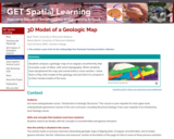
Play-Doh model of a geologic map Provenance: Carol Ormand Ph.D., Carleton College …
Play-Doh model of a geologic map
Provenance: Carol Ormand Ph.D., Carleton College Reuse: This item is offered under a Creative Commons Attribution-NonCommercial-ShareAlike license http://creativecommons.org/licenses/by-nc-sa/3.0/ You may reuse this item for non-commercial purposes as long as you provide attribution and offer any derivative works under a similar license. Students analyze a geologic map of an angular unconformity that truncates a pair of dikes, with some topography. When students have deciphered the map and constructed a cross-section, I show them a Play-Doh model of the geology and ask them to compare it to their mental model of the area.
(Note: this resource was added to OER Commons as part of a batch upload of over 2,200 records. If you notice an issue with the quality of the metadata, please let us know by using the 'report' button and we will flag it for consideration.)
LEARNING OBJECTIVES: Pupil will be able to define pressuresPupil will be able to …
LEARNING OBJECTIVES: Pupil will be able to define pressuresPupil will be able to reason various phenomena related to atmospheric pressurePupil will observe the demonstrations of effect of atmospheric pressure Objectives with specification :-REMEMBRING - Pupil defines the atmospheric pressure - pupil recalls the concept of atmospheric pressure· UNDERSTANDING - Pupil explains the concept of atmospheric pressure Pupil explains the direction of flow of liquid Pubil explains the direction of atmospheric pressureANALYSIS :bout pressure inside our body Pupil gives real life examples related to atmospheric pressurePupil compares the flow of liquid and gasess
This is a computer-based activity in which students retrieve data from websites …
This is a computer-based activity in which students retrieve data from websites maintained by the US Geological Survey (USGS) and the National Weather Service (NWS), and then use that data to test different hypotheses regarding streamflow and precipitation. Students import data from web sites into a spreadsheet program where they can construct scatter plots and perform simple statistical tests. The activity has two components, the first focusing on relations between streamflow and drainage basin characteristics (drainage area, slope, precipitation), the second focusing on trends in annual precipitation at two locations in the USA: Burlington, VT, and Boulder, CO. As part of the second component, students conduct a statistical test to determine if the long-term trends in precipitation are significant.
(Note: this resource was added to OER Commons as part of a batch upload of over 2,200 records. If you notice an issue with the quality of the metadata, please let us know by using the 'report' button and we will flag it for consideration.)
Spreadsheets Across the Curriculum module/Geology of National Parks course. Students estimate travel …
Spreadsheets Across the Curriculum module/Geology of National Parks course. Students estimate travel times and costs of a driving/camping trip to visit national parks in Colorado.
It's no secret that greenhouse gases warm the planet and that this …
It's no secret that greenhouse gases warm the planet and that this has dire consequences for the environment whole islands swallowed up by rising seas, animal and plant species stressed by higher temperatures, and upsets in ecological interactions as populations move to cooler areas. However, carbon dioxide has another, less familiar environmental repercussion: making the Earth's oceans more acidic. Higher levels of carbon dioxide in the atmosphere mean that more carbon dioxide dissolves in the ocean. This dissolved carbon dioxide forms carbonic acid the same substance that helps give carbonated beverages their acidic kick. While this process isn't going to make the ocean fizzy anytime soon, it is introducing its own set of challenges for marine organisms like plankton and coral.
The course treats the following topics: - Relevant physical oceanography - Elements …
The course treats the following topics: - Relevant physical oceanography - Elements of marine geology (seafloor topography, acoustical properties of sediments and rocks) - Underwater sound propagation (ray acoustics, ocean noise) - Interaction of sound with the seafloor (reflection, scattering) - Principles of sonar (beamforming) - Underwater acoustic mapping systems (single beam echo sounding, multi-beam echo sounding, sidescan sonar) - Data analysis (refraction corrections, digital terrain modelling) - Applications (hydrographic survey planning and navigation, coastal engineering) - Current and future developments.
This course will begin with brief overview of what important current research …
This course will begin with brief overview of what important current research topics are in oceanography (physical, geological, and biological) and how acoustics can be used as a tool to address them. Three typical examples are climate, bottom geology, and marine mammal behavior. Will then address the acoustic inverse problem, reviewing inverse methods (linear and nonlinear) and the combination of acoustical methods with other measurements as an integrated system. Last part of course will concentrate on specific case studies, taken from current research journals. This course is taught on campus at MIT and with simultaneous video at Woods Hole Oceanographic Institution.
By far most field trips in structural geology and regional tectonics do …
By far most field trips in structural geology and regional tectonics do NOT take place in large urban centers with a trip focus on mitigation of hazards. What is described here is an example of the instructional and learning opportunities associated with active tectonic examination of large population centers.
ACTIVE TECTONICS, HAZARDS, ACTIVE TECTONICS AND SOCIETY, URBAN GEOLOGY, EARTHQUAKES
(Note: this resource was added to OER Commons as part of a batch upload of over 2,200 records. If you notice an issue with the quality of the metadata, please let us know by using the 'report' button and we will flag it for consideration.)
This short activity (10--15 minutes) for Unit 1 introduces students to the …
This short activity (10--15 minutes) for Unit 1 introduces students to the general relationship between economic development and resource use, and, particularly with the follow-up homework, the relationship among growing populations, increasing economic development, and natural resource extraction. The activity is intended to be completed by individuals or small groups but could also be used for a guided class discussion. This activity serves as a transition to Unit 2.
(Note: this resource was added to OER Commons as part of a batch upload of over 2,200 records. If you notice an issue with the quality of the metadata, please let us know by using the 'report' button and we will flag it for consideration.)
During Activity 2.2, students download, organize, and analyze geoscience data sets of …
During Activity 2.2, students download, organize, and analyze geoscience data sets of sea level trends, terrestrial ice sheet trends, and intensity of tropical cyclones as well as forecast models of atmospheric CO2 and temperature trends and sea level rise. Students utilize the methods of geoscience such as systems thinking and using multiple lines of evidence to determine possible relationships and feedbacks among the data sets. Students use this data to construct their argument from evidence for a position paper in Activity 2.3.
(Note: this resource was added to OER Commons as part of a batch upload of over 2,200 records. If you notice an issue with the quality of the metadata, please let us know by using the 'report' button and we will flag it for consideration.)
This activity is intended to fill the first part of a class …
This activity is intended to fill the first part of a class period on mining and mining impacts. It is a hands-on activity in which students, in small groups, "mine" the blueberries or chocolate chips out of a muffin. This activity helps to review the reading materials and facilitate discussion about mining and mining methods, waste, beneficiation, landscape destruction, reclamation methods, and more.
(Note: this resource was added to OER Commons as part of a batch upload of over 2,200 records. If you notice an issue with the quality of the metadata, please let us know by using the 'report' button and we will flag it for consideration.)
This activity focuses on the interrelationships of ore grades, economics, mining impacts/decisions, …
This activity focuses on the interrelationships of ore grades, economics, mining impacts/decisions, and other factors. It is intended as a small-group activity, where different groups of students work on one of three different parts, with classroom discussion as a follow-up.
(Note: this resource was added to OER Commons as part of a batch upload of over 2,200 records. If you notice an issue with the quality of the metadata, please let us know by using the 'report' button and we will flag it for consideration.)
Even though students will read about sedimentary processes and the mineral resources …
Even though students will read about sedimentary processes and the mineral resources thus formed, they will need some practice in order to truly grasp the concepts.
(Note: this resource was added to OER Commons as part of a batch upload of over 2,200 records. If you notice an issue with the quality of the metadata, please let us know by using the 'report' button and we will flag it for consideration.)
Students will analyze data and answer questions regarding the weathering, erosion, and …
Students will analyze data and answer questions regarding the weathering, erosion, and deposition responsible for concentrating shoreline titanium placer deposits in Florida.
(Note: this resource was added to OER Commons as part of a batch upload of over 2,200 records. If you notice an issue with the quality of the metadata, please let us know by using the 'report' button and we will flag it for consideration.)
No restrictions on your remixing, redistributing, or making derivative works. Give credit to the author, as required.
Your remixing, redistributing, or making derivatives works comes with some restrictions, including how it is shared.
Your redistributing comes with some restrictions. Do not remix or make derivative works.
Most restrictive license type. Prohibits most uses, sharing, and any changes.
Copyrighted materials, available under Fair Use and the TEACH Act for US-based educators, or other custom arrangements. Go to the resource provider to see their individual restrictions.