This class is developed around the concept of disobedient interference within the …
This class is developed around the concept of disobedient interference within the existing models of production of space and knowledge. Modeling is the main modus operandi of the class as students will be required to make critical diagrammatic cuts through processes of production in different thematic registers – from chemistry, law and economy to art, architecture and urbanism – in order to investigate the sense of social responsibility and control over the complex agendas embedded in models that supports production of everyday objects and surroundings. Students will be encouraged to explore relations between material or immaterial aspects and agencies of production, whether they emerged as a consequence of connection of mind, body and space, or the infrastructural, geographical and ecological complexities of the Anthropocene. These production environments will be taken as modeling settings.
This studio explores the notion of in-between by engaging several relationships; the …
This studio explores the notion of in-between by engaging several relationships; the relationship between intervention and perception, between representation and notation and between the fixed and the temporal. In the Exactitude in Science, Jorge Luis Borges tells the perverse tale of the one to one scale map, where the desire for precision and power leads to the escalating production of larger and more accurate maps of the territory. For Jean Baudrillard, "The territory no longer precedes the map nor survives it. …it is the map that precedes the territory... and thus, it would be the territory whose shreds are slowly rotting across the map." The map or the territory, left to ruin-shredding across the 'other', beautifully captures the tension between reality and representation. Mediating between collective desire and territorial surface, maps filter, create, frame, scale, orient, and project. A map has agency. It is not merely representational but operational, the experience and discursive potential of this process lies in the reciprocity between the representation and the real. It is in-between these specific sets of relationships that this studio positions itself.
This is the second undergraduate architecture design studio, which introduces design logic …
This is the second undergraduate architecture design studio, which introduces design logic and skills that enable design thinking, representation, and development. Through the lens of nano-scale machines, technologies, and phenomena, students are asked to explore techniques for describing form, space, and architecture. Exercises encourage various connotations of the "machine" and challenge students to translate conceptual strategies into more integrated design propositions through both digital and analog means.
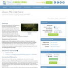
Finding themselves in the middle of the Amazon rainforest after a plane …
Finding themselves in the middle of the Amazon rainforest after a plane crash, students use map scales, keys, and longitude and latitude coordinates to figure out where they are. Then they work in groups to generate ideas and make plans. They decide where they should go to be rescued, the distance to that location, the route to take, and make calculations to estimate walking travel time.
Students create models of objects of their choice, giving them skills and …
Students create models of objects of their choice, giving them skills and practice in techniques used by professionals. They make sketches as they build their objects. This activity facilitates a discussion on models and their usefulness.
In this lesson, students find their location on a map using Latitude …
In this lesson, students find their location on a map using Latitude and Longitudinal coordinates. They determine where they should go to be rescued and how best to get there.
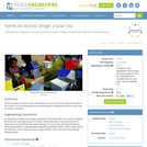
Students design and build a model city powered by the sun! They …
Students design and build a model city powered by the sun! They learn about the benefits of solar power, and how architectural and building engineers integrate photovoltaic panels into the design of buildings.
How can an understanding of pH—a logarithmic scale used to identify the …
How can an understanding of pH—a logarithmic scale used to identify the acidity or basicity of a water-based solution—be used to design and create a color-changing paint? This activity provides students the opportunity to extract dyes from natural products and test dyes for acids or bases as teams develop a prototype “paint” that is eventually applied to help with a wall redesign at a local children’s hospital. Students learn about how dyes are extracted from organic material and use the engineering design process to test dyes using a variety of indicators to achieve the right color for their prototype. Students iterate on their dyes and use ratios and proportions to calculate the amount of dye needed to successfully complete their painting project.
Students are introduced to detail drawings and the importance of clearly documenting …
Students are introduced to detail drawings and the importance of clearly documenting and communicating their designs. They are introduced to the American National Standards Institute (ANSI) Y14.5 standard, which controls how engineers communicate and archive design information. They are introduced to standard paper sizes and drawing view conventions, which are major components of the Y14.5 standard.
Several power points, quiz, study guide, and worksheets about the Earth, Moon, …
Several power points, quiz, study guide, and worksheets about the Earth, Moon, Sun relationships. I developed these for 6th grade science class as support for other materials. Items are great for visual learners and include concepts of scale, seasons / earth tilt, and path of the sun.
Students will use various objects in the classroom to experiment with nonstandard …
Students will use various objects in the classroom to experiment with nonstandard measurement. They will make estimates and test them out. Then, working in pairs or small groups, students will use a ruler or a measuring tape to become familiar with how to use these tools for standard linear measurement. The purpose of this activity is to practice making standard and non-standard measurement and to learn the purpose of making linear measurements and how to apply them to scientific investigations. Students will learn how to make measurements, both nonstandard and standard (with a ruler). They will test their estimates and record their results.
To evaluate the different integumentary systems found in the animal kingdom, students …
To evaluate the different integumentary systems found in the animal kingdom, students conduct an exploratory research-based lab. During the activity, students create a model epidermis that contains phosphorescent powder and compare the results to a control model. After learning about the variations of integumentary systems—systems that comprise the skin and other appendages that act to protect animal bodies from damage—students act as engineers to mimic animal skin samples. Their goal is to create a skin sample that closely represents the animal they are mimicking while protecting the base ‘epidermis’ from UV light.
This class introduces students to the rudiments of Western music through oral, …
This class introduces students to the rudiments of Western music through oral, aural, and written practice utilizing rhythm, melody, intervals, scales, chords, and musical notation. The approach is based upon the inclusive Kodály philosophy of music education. Individual skills are addressed through a variety of means, emphasizing singing and keyboard practice in the required piano labs.
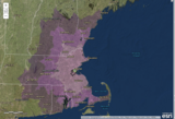
In this data rich world, we need to understand how things are …
In this data rich world, we need to understand how things are organized on the Earth's surface. Those things are represented by spatial data and necessarily depend upon what surrounds them. Spatial statistics provide insights into explaining processes that create patterns in spatial data. In geographical information analysis, spatial statistics such as point pattern analysis, spatial autocorrelation, and spatial interpolation will analyze the spatial patterns, spatial processes, and spatial association that characterize spatial data. Understanding spatial analysis will help you realize what makes spatial data special and why spatial analysis reveals a truth about spatial data.
Students take on the role of geographers and civil engineers and use …
Students take on the role of geographers and civil engineers and use a device enabled with the global positioning system (GPS) to locate geocache locations via a number of waypoints. Teams save their data points, upload them to geographic information systems (GIS) software, such as Google Earth, and create scale drawings of their explorations while solving problems of area, perimeter and rates. The activity is unique in its integration of technology for solving mathematical problems and asks students to relate GPS and GIS to engineering.
No restrictions on your remixing, redistributing, or making derivative works. Give credit to the author, as required.
Your remixing, redistributing, or making derivatives works comes with some restrictions, including how it is shared.
Your redistributing comes with some restrictions. Do not remix or make derivative works.
Most restrictive license type. Prohibits most uses, sharing, and any changes.
Copyrighted materials, available under Fair Use and the TEACH Act for US-based educators, or other custom arrangements. Go to the resource provider to see their individual restrictions.