DATA: Global Digital Elevation Model (DEM) TOOLS: GeoMapApp, Spreadsheet SUMMARY: Use GeoMapApp …
DATA: Global Digital Elevation Model (DEM) TOOLS: GeoMapApp, Spreadsheet SUMMARY: Use GeoMapApp to search for evidence of glacial expansion and retreat. Produce a research report of your findings modeled on peer-reviewed papers in the field of glaciology.
(Note: this resource was added to OER Commons as part of a batch upload of over 2,200 records. If you notice an issue with the quality of the metadata, please let us know by using the 'report' button and we will flag it for consideration.)
Students work in pairs on this worksheet and strengthen their background knowledge …
Students work in pairs on this worksheet and strengthen their background knowledge by identifying different features in photographs of Earth's surface. Then to build on this base, the students need to determine the key processes that form each of the features. To address a common misconception, students read a debate between two hypothetical students and need to determine which student is stating the scientifically correct idea. The project is summarized by a question posed about the features on a hypothetical planet.
(Note: this resource was added to OER Commons as part of a batch upload of over 2,200 records. If you notice an issue with the quality of the metadata, please let us know by using the 'report' button and we will flag it for consideration.)
This activity leads to understanding common landslide hazards in the area and …
This activity leads to understanding common landslide hazards in the area and how they relate to weather patterns and/or local geology.
(Note: this resource was added to OER Commons as part of a batch upload of over 2,200 records. If you notice an issue with the quality of the metadata, please let us know by using the 'report' button and we will flag it for consideration.)
This assignment requires students to visit a local geologic feature. Students choose …
This assignment requires students to visit a local geologic feature. Students choose a field site, visit it and observe features such as weathering, rock type, folding, or faulting. At their field site, they are encouraged to make sketches and take photographs. They will turn in a description of the site, geologic origin, and geomorphologic evolution. This assignment is especially useful for non-majors who may not normally be interested in outdoor activities.
(Note: this resource was added to OER Commons as part of a batch upload of over 2,200 records. If you notice an issue with the quality of the metadata, please let us know by using the 'report' button and we will flag it for consideration.)
Students should download Google Earth and the kmz file prior to class …
Students should download Google Earth and the kmz file prior to class if using personal computers, otherwise both should be downloaded on class computers. In class time is one lab period, with some out of class time; ~6 hrs total.
(Note: this resource was added to OER Commons as part of a batch upload of over 2,200 records. If you notice an issue with the quality of the metadata, please let us know by using the 'report' button and we will flag it for consideration.)
The Fourth Grade Elementary Framework for Science and Integrated Subjects, What Happened …
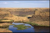
The Fourth Grade Elementary Framework for Science and Integrated Subjects, What Happened at Dry Falls?, uses the phenomena of a local Washington landform to explore erosion from the Ice Age Floods. It is part of Elementary Framework for Science and Integrated Subjects project, a statewide Clime Time collaboration among ESD 123, ESD 105, North Central ESD, and the Office of Superintendent of Public Instruction. Development of the resources is in response to a need for research- based science lessons for elementary teachers that are integrated with English language arts, mathematics and other subjects such as social studies. The template for Elementary Science and Integrated Subjects can serve as an organized, coherent and research-based roadmap for teachers in the development of their own NGSS aligned science lessons. Lessons can also be useful for classrooms that have no adopted curriculum as well as to serve as enhancements for current science curriculum. The EFSIS project brings together grade level teams of teachers to develop lessons or suites of lessons that are 1) pnenomena based, focused on grade level Performance Expectations, and 2) leverage ELA and Mathematics Washington State Learning Standards.
Designed for an introductory geology course (Note: this resource was added to …
Designed for an introductory geology course
(Note: this resource was added to OER Commons as part of a batch upload of over 2,200 records. If you notice an issue with the quality of the metadata, please let us know by using the 'report' button and we will flag it for consideration.)
This activity is an inquiry-based field investigation of the geologic history of …
This activity is an inquiry-based field investigation of the geologic history of the Minnehaha Falls and St. Anthony Falls areas of Minneapolis. Students will be introduced to rocks and the stories rocks tell in a genuine geologic context, rather than as samples in the classroom.
Short Description: This is an inquiry based field investigation where students gather …
Short Description: This is an inquiry based field investigation where students gather data on the Credit River from the rocks in the river bed, water speed, and maps. Students interpret their findings and develop new questions.
Please see the related test//problem set. Integrates geomorphology into a core course …
Please see the related test//problem set. Integrates geomorphology into a core course in geology Designed for an introductory geology course Has minimal/no quantitative component Uses geomorphology to solve problems in other fields
(Note: this resource was added to OER Commons as part of a batch upload of over 2,200 records. If you notice an issue with the quality of the metadata, please let us know by using the 'report' button and we will flag it for consideration.)
Each student must choose a current news article that relates to geomorphology. …
Each student must choose a current news article that relates to geomorphology. Each student will given an oral presentation about the article, including a synopsis of the story and a description of geomorphic processes that are involved. The other students are able to ask questions. The activity gives the students a chance to relate what they are learning about in class to current events and social issues. Designed for a geomorphology course Has minimal/no quantitative component
(Note: this resource was added to OER Commons as part of a batch upload of over 2,200 records. If you notice an issue with the quality of the metadata, please let us know by using the 'report' button and we will flag it for consideration.)
In this activity, students use Google Earth Pro to examine and measure …
In this activity, students use Google Earth Pro to examine and measure sedimentary and geomorphic structures related to the late Pleistocene draining of glacial Lake Missoula and Lake Bonneville.
(Note: this resource was added to OER Commons as part of a batch upload of over 2,200 records. If you notice an issue with the quality of the metadata, please let us know by using the 'report' button and we will flag it for consideration.)
This activity is a interdisciplinary field investigation where students will form observations …
This activity is a interdisciplinary field investigation where students will form observations and make calculations about stream characteristics and stream flow.
This activity is a field investigation where students will observe the topography …
This activity is a field investigation where students will observe the topography of Big Stone Lake and generate questions about the history of this area.
This activity is a field investigation where students make observations in the …
This activity is a field investigation where students make observations in the Minnesota River valley, discuss their findings amongst other student groups, and describe how those observations fit with the general geology of Minnesota.
This activity is a combination of a field investigation and direct instruction …
This activity is a combination of a field investigation and direct instruction at Minnehaha Falls. We are investigating Twin Cities rock types and weathering from the flowing water.
Students map one large hairpin parabolic dune in the Pinebush Preserve. They …
Students map one large hairpin parabolic dune in the Pinebush Preserve. They also profile the slopes on both proximal and distal sides of the dune. As a group, we take an ~ 2m long core of the dune sand to sample the sand beneath the soil profile. In the lab, students measure the particle size distribution of their sand samples, map the whole dune field from aerial photographs and a DEM, and estimate paleo-wind speed and direction. They then compare these data with modern wind data (available from the web) to answer the question of .just how different conditions were when the dune field was deposited Uses online and/or real-time data Addresses student fear of quantitative aspect and/or inadequate quantitative skills Uses geomorphology to solve problems in other fields
(Note: this resource was added to OER Commons as part of a batch upload of over 2,200 records. If you notice an issue with the quality of the metadata, please let us know by using the 'report' button and we will flag it for consideration.)
This class exercise is an opportunity for students to gain valuable field …
This class exercise is an opportunity for students to gain valuable field experiences and develop fieldwork skills. The goal is to have students compare their measurements of a bankfull channel and its bed sediments with theoretical values that might imply whether the channel is 'adjusted' or is out of equilibrium with its setting. This is accomplished by having the students calculate a bankfull Shields stress value and then compare that value with both: (1) a theoretical range of values that might comprise an 'adjusted' condition, and (2) experimental values for the minimal Shields stress required to entrain bed grains of different sizes. They are then to evaluate whether the channel is stable or not. Designed for a geomorphology course
(Note: this resource was added to OER Commons as part of a batch upload of over 2,200 records. If you notice an issue with the quality of the metadata, please let us know by using the 'report' button and we will flag it for consideration.)
Each student or pair of students is provided with an illustration of …
Each student or pair of students is provided with an illustration of a landscape, landform, or geomorphic process and asked to place it in the appropriate location on the timescale answer form (Acrobat (PDF) 8kB Feb28 12) (see the list of landforms and geomorphic processes (Excel 74kB May8 12)). The landforms and processes list includes information on time ranges for each time, time in seconds, and time in years. Note that the time ranges represent approximate values for the processes and that the time in seconds and time in years columns represent low-end values for each respective process. Thus, some processes may fit into multiple locations on the timescale answer form and some revision by students will occur during the initial phase of the activity.
After students have completed their first iteration of the timescale, the instructor will assess the placement of each process on the answer form (Acrobat (PDF) 8kB Feb28 12). The instructor will then determine which processes need further explanation. For some processes, lecture or other learning strategies might be implemented if students do not have a good understanding of the scale in which they occur. For other processes, the instructor may facilitate a discussion to lead students to expand, contract, or alter their perceptions of the time range.
Ultimately, and perhaps towards the end of the lecture period or as a quiz, students will again be asked to complete the timescale answer form.
(Note: this resource was added to OER Commons as part of a batch upload of over 2,200 records. If you notice an issue with the quality of the metadata, please let us know by using the 'report' button and we will flag it for consideration.)
No restrictions on your remixing, redistributing, or making derivative works. Give credit to the author, as required.
Your remixing, redistributing, or making derivatives works comes with some restrictions, including how it is shared.
Your redistributing comes with some restrictions. Do not remix or make derivative works.
Most restrictive license type. Prohibits most uses, sharing, and any changes.
Copyrighted materials, available under Fair Use and the TEACH Act for US-based educators, or other custom arrangements. Go to the resource provider to see their individual restrictions.