In this laboratory exercise students will have an opportunity to examine the …
In this laboratory exercise students will have an opportunity to examine the crystal structures, optical properties and health hazards of the common asbestos minerals. The laboratory will reinforce optical microscopic skills that students have learned in mineralogy and show them how mineralogy can be critical to understanding a current public policy issue.
(Note: this resource was added to OER Commons as part of a batch upload of over 2,200 records. If you notice an issue with the quality of the metadata, please let us know by using the 'report' button and we will flag it for consideration.)
Assemble a regional geologic history by compiling observations made a several sites. …
Assemble a regional geologic history by compiling observations made a several sites.
(Note: this resource was added to OER Commons as part of a batch upload of over 2,200 records. If you notice an issue with the quality of the metadata, please let us know by using the 'report' button and we will flag it for consideration.)
LiDAR-Derived Digital Outcrops, 3D Hand Samples, Petrography, and Geochemistry Short Description: Classic …
LiDAR-Derived Digital Outcrops, 3D Hand Samples, Petrography, and Geochemistry
Short Description: Classic Central Gneiss Belt of the Grenville outcrops are revealed in this image-dense geological reference book. Each site is complete with 3D models of outcrops, rock samples, and virtual thin sections. Geochemical data is also available for some samples. High resolution images of thin sections and more detailed descriptions are available to post-secondary instructors upon request.
Word Count: 7112
(Note: This resource's metadata has been created automatically by reformatting and/or combining the information that the author initially provided as part of a bulk import process.)
LiDAR-Derived Digital Outcrops, 3D Hand Samples, Petrography, and Geochemistry Short Description: Classic …
LiDAR-Derived Digital Outcrops, 3D Hand Samples, Petrography, and Geochemistry
Short Description: Classic Central Metasedimentary Belt of the Grenville outcrops are revealed in this image-dense geological reference book. Each site is complete with 3D models of outcrops, rock samples, and virtual thin sections. Geochemical data is also available for some samples. High resolution images of thin sections and more detailed descriptions are available to post-secondary instructors upon request.
Word Count: 5365
(Note: This resource's metadata has been created automatically by reformatting and/or combining the information that the author initially provided as part of a bulk import process.)
The impact of natural disasters is made vivid in this video segment …
The impact of natural disasters is made vivid in this video segment adapted from NOVA. A small town in Iceland, prepared for recurrent avalanches, is devastated when one takes a new and damaging path.
There are now about 170 identified impact craters on the Earth, and …
There are now about 170 identified impact craters on the Earth, and this number is growing, ever since the well known discovery of Meteor Crater in 1920s. Currently, multi-interdisciplinary research studies of impact structures are getting conducted in fields like mineralogy, petrology, environmental geology, and marine biology. The course objectives are to introduce basic principles of impact cratering, understand the application of analytical tools, and become familiar with geological, geochemical and environmental studies. This course is offered during the Independent Activities Period (IAP), which is a special 4-week term at MIT that runs from the first week of January until the end of the month.
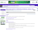
In this project, students interpret a high-resolution image of result from an …
In this project, students interpret a high-resolution image of result from an experimental run of the Jurrasic Tank sedimentation simulator at the St. Anthony Falls Lab at the University of Minnesota. They are expected to interpret depositional environments, characterize simulated stratigraphic sections, and interpret the overall sedimentary architecture of the simulated basin. All of these observations are to put together onto a poster which is the final product of the project.
(Note: this resource was added to OER Commons as part of a batch upload of over 2,200 records. If you notice an issue with the quality of the metadata, please let us know by using the 'report' button and we will flag it for consideration.)
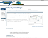
This is one component of the Rupturing Continental Lithosphere suite of mini-lessons. …
This is one component of the Rupturing Continental Lithosphere suite of mini-lessons. Students investigate the morphology of rifted margins by creating topographic/bathymetric maps and profiles across the Red Sea and the Gulf of California (using GeoMapApp ), and describe north-to-south variations in basin morphology in the Gulf of California (including making graphs using Excel). This lab exercise will allow students to examine the roles of structural evolution, sedimentation, and physical and chemical evolution of the crust in the rifting process. This lesson can act as an introduction to more detailed examinations of the roles of sedimentation and obliquity in rifted margins.
This video segment describes how the Australopithecus afarensis skeleton known as Lucy …
This video segment describes how the Australopithecus afarensis skeleton known as Lucy could have been fossilized. Footage courtesy of NOVA: "In Search of Human Origins."
Working with data, students develop 3-D understandings of Earth structures using inference …
Working with data, students develop 3-D understandings of Earth structures using inference to construct a block diagram from a collection of 2-D information.
(Note: this resource was added to OER Commons as part of a batch upload of over 2,200 records. If you notice an issue with the quality of the metadata, please let us know by using the 'report' button and we will flag it for consideration.)
X-ray diffraction is a quick and valuable tool for identifying minerals. Minerals …
X-ray diffraction is a quick and valuable tool for identifying minerals. Minerals are an integral portion of our everyday life, in addition to composing our planet! They help bring electricity into our homes and remove our bathtub rings. In this lab, students analyze the X-ray diffraction patterns of three household cleansers, Ajax, White Magic, and Soft Scrub, in order to identify the abrasive minerals in each.
(Note: this resource was added to OER Commons as part of a batch upload of over 2,200 records. If you notice an issue with the quality of the metadata, please let us know by using the 'report' button and we will flag it for consideration.)
The 50-minute group-based activity for hundreds of students starts by constructing bio-zones …
The 50-minute group-based activity for hundreds of students starts by constructing bio-zones for a given set of fossil ranges. Results are reviewed using a sequence of clicker questions to discuss the optimal biostratigraphic decisions, the necessary types of thinking, and how to articulate a concise yet complete textual description of corresponding biozones.
A set of stratigraphic logs is then used to interpret changes in depositional environment across space and time. Students also decide (and justify decisions) on the optimal choice of fossils for use when interpreting variations in depositional environment. The final result is an interpreted geologic section based on stratigraphic and biostratigraphic data.
This interpretive exercise is only three weeks into a first course on Earth and life through time, so guidance is provided using carefully designed question sequences posed using "clicker" (personal response system) and/or for individual or whole class discussion.
(Note: this resource was added to OER Commons as part of a batch upload of over 2,200 records. If you notice an issue with the quality of the metadata, please let us know by using the 'report' button and we will flag it for consideration.)
Storms can have devastating impacts on coastal communities. Typically, tropical storms like …
Storms can have devastating impacts on coastal communities. Typically, tropical storms like hurricanes get the most attention, but there are other types of storms that occur at more northern latitudes that can be just as destructive. For example, in January of 2018, Winter Storm Grayson caused more than 300,000 power outages and $1.1 billion in damage, and resulted in 22 confirmed casualties along the eastern seaboard. In this module, students will learn how barometric pressure changes during a storm, analyze the effect of storms on oceanographic variables, classify a storm as a bomb cyclone, and compare a bomb cyclone to a hurricane. Ultimately students will use their quantitative reasoning skills to manipulate and visualize data during storms in the northeastern United States.
(Note: this resource was added to OER Commons as part of a batch upload of over 2,200 records. If you notice an issue with the quality of the metadata, please let us know by using the 'report' button and we will flag it for consideration.)
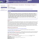
Question Suppose that you are building a new house. It will take …
Question Suppose that you are building a new house. It will take about 90 kg (198 pounds) of copper to do the electrical wiring. In order to get the copper in the first place, someone needs to mine solid rock that contains copper, extract the copper minerals, throw away the waste rock, and smelt the copper minerals to produce copper metal. Rocks mined for copper typically contain only very small percentages of copper -- about 0.7% in the case of most of the big porphyry copper deposits of the world. How much rock would someone have to mine in order to extract enough copper to wire your new house?
(Note: this resource was added to OER Commons as part of a batch upload of over 2,200 records. If you notice an issue with the quality of the metadata, please let us know by using the 'report' button and we will flag it for consideration.)
There are many, including my environmental and civil engineering technology students, who …
There are many, including my environmental and civil engineering technology students, who do not have decades to commit to developing a working understanding of the Earth and the specific geological and geomorphological contexts they may find themselves working in. Therefore, this textbook is designed to provide a brief introduction to the concepts of geology and geomorphology, with an Ontarian perspective. It serves as a good starting point for individuals who have neither prior experience nor knowledge in geology nor geomorphology. In order to adequately explain concepts that unfold in four dimensions (3 dimensions with time as the fourth), an electronic format is used to leverage enhanced illustrations. These illustrations include traditional 2D figures; however, videos, animations, and interactive figures are also used to help create a deeper understanding.
BRIGHT Girls was a project to build broader participation in the sciences, …
BRIGHT Girls was a project to build broader participation in the sciences, led by the University of Alaska Fairbanks and funded by the National Science Foundation. We sought to increase students' motivation and capacity to pursue careers in STEM by engaging them in studies of nearby natural environments. The developed lesson plans may be used in formal or informal educational settings, e.g., in a summer academy or across multiple class periods. These investigations help students explore the relationships among life history and ecosystems, connecting biology to geology and remote sensing.
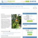
Students design and construct devices to trap insects that are present in …
Students design and construct devices to trap insects that are present in the area around the school. The objective is to ask the right design questions and conduct the right tests to determine if the traps work .
In association with rock and mineral ID tables, this lab introduces students …
In association with rock and mineral ID tables, this lab introduces students to basic rocks and minerals via grouping and comparison, rather than as individual samples. I use this lab in my environmental geology course, where we don't have enough lab time to examine each set of rocks and minerals separately, but students need a basic familiarity with these materials and a context in which to place them. I find these groupings teach them how to look at rocks and minerals and give them the cursory experience identifying geologic materials necessary to go on successfully in the course.
(Note: this resource was added to OER Commons as part of a batch upload of over 2,200 records. If you notice an issue with the quality of the metadata, please let us know by using the 'report' button and we will flag it for consideration.)
This activity involves building crystal structure ball models in order to strengthen …
This activity involves building crystal structure ball models in order to strengthen students' understanding of crystalline order, relative atomic size, atomic coordination, crystal chemistry, and crystal symmetry.
(Note: this resource was added to OER Commons as part of a batch upload of over 2,200 records. If you notice an issue with the quality of the metadata, please let us know by using the 'report' button and we will flag it for consideration.)
This course covers examination of the state of knowledge of planetary formation, …
This course covers examination of the state of knowledge of planetary formation, beginning with planetary nebulas and continuing through accretion (from gas, to dust, to planetesimals, to planetary embryos, to planets). It also includes processes of planetary differentiation, crust formation, atmospheric degassing, and surface water condensation. This course has integrated discussions of compositional and physical processes, based upon observations from our solar system and from exoplanets. Focus on terrestrial (rocky and metallic) planets, though more volatile-rich bodies are also examined.
No restrictions on your remixing, redistributing, or making derivative works. Give credit to the author, as required.
Your remixing, redistributing, or making derivatives works comes with some restrictions, including how it is shared.
Your redistributing comes with some restrictions. Do not remix or make derivative works.
Most restrictive license type. Prohibits most uses, sharing, and any changes.
Copyrighted materials, available under Fair Use and the TEACH Act for US-based educators, or other custom arrangements. Go to the resource provider to see their individual restrictions.