The primary objective of this U.S. Geological Survey Open-file Report is to …
The primary objective of this U.S. Geological Survey Open-file Report is to improve seismic-hazard assessments in regions of Wyoming with low to moderate levels of historic seismicity. A map and pamphlet are available for download in PDF format. The map shows faults and folds with evidence of Quaternary movement including data on timing of the most recent movement, sense of movement, slip rate, and continuity of surface expression.
In the Mapping Earthquakes to Save the World activity, students leverage real-time …
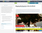
In the Mapping Earthquakes to Save the World activity, students leverage real-time data to plot earthquakes on a world map. The fate of the world is in their hands – the President of the United States has asked for their help to save humankind. Students identify patterns in their data and connect earthquakes with tectonic plates, making recommendations back to the President about where people are safe and where people are most at risk. This activity was heavily inspired by a project from the Stevens Institute for Technology Center for Innovation in Engineering and Science Education.
In the Mapping Earthquakes to Save the World activity, students leverage real-time …
In the Mapping Earthquakes to Save the World activity, students leverage real-time data to plot earthquakes on a world map. The fate of the world is in their hands – the President of the United States has asked for their help to save humankind. Students identify patterns in their data and connect earthquakes with tectonic plates, making recommendations back to the President about where people are safe and where people are most at risk. This activity was heavily inspired by a project from the Stevens Institute for Technology Center for Innovation in Engineering and Science Education.
In this activity, students will learn about the Mercalli Scale for rating …
In this activity, students will learn about the Mercalli Scale for rating earthquakes. Also, students will make a booklet with drawings that represent each rating of the scale.
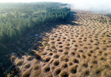
The Mima mounds are small, irregularly spaced hills, described by some as …
The Mima mounds are small, irregularly spaced hills, described by some as “soil pimples” because they are piles of silt, sand, and pebbles.Scientists still don't know what created the Mima mounds. These resources will invite students to develop their own hypotheses, evaluate the existing evidence, and construct an explanation.Start with the "Mima mounds educator guide" to learn about the available resources, alignment to learning standards, and opportunities for modification and extension. The educator guide also includes student worksheets to guide inquiry and exploration. The attached "Mima mounds booklet" was created by the Washington Geologic Survey, within the Washington Department of Natural Resources. It is an illustrated guide to the mounds and the hypotheses about what formed them. The educator guide will walk you through ways to use the booklet. You can contact DNR's Youth Education and Outreach Program at yeop@dnr.wa.gov with any questions.
Students are introduced to our planet's structure and its dynamic system of …
Students are introduced to our planet's structure and its dynamic system of natural forces through an examination of the natural hazards of earthquakes, volcanoes, landslides, tsunamis, floods and tornados, as well as avalanches, fires, hurricanes and thunderstorms. They see how these natural events become disasters when they impact people, and how engineers help to make people safe from them. Students begin by learning about the structure of the Earth; they create clay models showing the Earth's layers, see a continental drift demo, calculate drift over time, and make fault models. They learn how earthquakes happen; they investigate the integrity of structural designs using model seismographs. Using toothpicks and mini-marshmallows, they create and test structures in a simulated earthquake on a tray of Jell-O. Students learn about the causes, composition and types of volcanoes, and watch and measure a class mock eruption demo, observing the phases that change a mountain's shape. Students learn that the different types of landslides are all are the result of gravity, friction and the materials involved. Using a small-scale model of a debris chute, they explore how landslides start in response to variables in material, slope and water content. Students learn about tsunamis, discovering what causes them and makes them so dangerous. Using a table-top-sized tsunami generator, they test how model structures of different material types fare in devastating waves. Students learn about the causes of floods, their benefits and potential for disaster. Using riverbed models made of clay in baking pans, students simulate the impact of different river volumes, floodplain terrain and levee designs in experimental trials. They learn about the basic characteristics, damage and occurrence of tornadoes, examining them closely by creating water vortices in soda bottles. They complete mock engineering analyses of tornado damage, analyze and graph US tornado damage data, and draw and present structure designs intended to withstand high winds.
Students learn about frequency and period, particularly natural frequency using springs. They …
Students learn about frequency and period, particularly natural frequency using springs. They learn that the natural frequency of a system depends on two things: the stiffness and mass of the system. Students see how the natural frequency of a structure plays a big role in the building surviving an earthquake or high winds.
Students are introduced to natural disasters, and learn the difference between natural …
Students are introduced to natural disasters, and learn the difference between natural hazards and natural disasters. They discover the many types of natural hazards avalanche, earthquake, flood, forest fire, hurricane, landslide, thunderstorm, tornado, tsunami and volcano as well as specific examples of natural disasters. Students also explore why understanding these natural events is important to engineers and everyone's survival on our planet.
Learn how plate tectonics plays a critical role in shaping the onshore …
Learn how plate tectonics plays a critical role in shaping the onshore and offshore terrain around La Jolla.Ę Dr. Neal Driscoll will present new offshore data illustrating the interplay between sediments, tectonics and sea level. (56 minutes)
Updated Fall 2023 This textbook was designed especially for Community College students, …
Updated Fall 2023
This textbook was designed especially for Community College students, as a resource to instill the knowledge and adventure that the discipline of geography holds for so many of us. The following units will cover a wide array of topics such as: Earth’s grid system, weather, climate, rivers, oceans, deserts, basic geology, and cartography. This book also integrates virtual field trips and interactive multimedia.
The Text Has 19 units; Unit 1: Introduction to Geography as a Discipline Unit 2: Earth’s Place within the Cosmos Unit 3: Introduction to Geology & Geologic Time Unit 4: Mapping Earth’s Surface Unit 5: Earth-Sun Relationships: Reasons for the Seasons Unit 6: Earth’s Atmosphere Unit 7: Elements of Weather & Climate Unit 8: Basic Mineral Development Unit 9: Igneous Rocks Unit 10: Sedimentary Rocks Unit 11: Metamorphism & Metamorphic Rocks Unit 12: Weathering & Soils Unit 13: Earths Dynamic Surface: Plate Tectonics Unit 14: Earths Dynamic Surface: Tectonics Force Unit 15: Earths Dynamic Surface: Volcanoes Unit 16: Shaped by Coastal Processes Unit 17: Shaped by Rivers & Running Water Unit 18: Shaped by Wind as a Geomorphic Agent Unit 19: Shaped by Glaciers
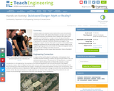
Students explore the physical science behind the causes of quicksand and become …
Students explore the physical science behind the causes of quicksand and become familiar with relationship between concepts such as total stress, pore pressure, and effective stress. Students also relate these concepts to soil liquefaction—a major concern during earthquakes. Students begin the activity by designing a simple device to test the effects of quicksand on materials of different densities and weights. They prototype a support structure that works to prevent a heavy object from sinking into quicksand. At the end of the activity, students reflect on the engineering design process and consider the steps civil engineers take in designing sturdy buildings and other structures.
Travel to the Pacific Northwest, home to some of the most seismically …
Travel to the Pacific Northwest, home to some of the most seismically active areas in the U.S. Learn from experts about tectonic activity and find out if they know when the "big one†will hit.
Students learn about various natural hazards and specific methods engineers use to …
Students learn about various natural hazards and specific methods engineers use to prevent these hazards from becoming natural disasters. They study a hypothetical map of an area covered with natural hazards and decide where to place natural disaster prevention devices by applying their critical thinking skills and an understanding of the causes of natural disasters.
This course examines the science of natural catastrophes such as earthquakes and …
This course examines the science of natural catastrophes such as earthquakes and hurricanes and explores the relationships between the science of and policy toward such hazards. It presents the causes and effects of these phenomena, discusses their predictability, and examines how this knowledge influences policy making. This course includes intensive practice in the writing and presentation of scientific research and summaries for policy makers.
Students learn about the types of seismic waves produced by earthquakes and …
Students learn about the types of seismic waves produced by earthquakes and how they move the Earth. The dangers of earthquakes are presented as well as the necessity for engineers to design structures for earthquake-prone areas that are able to withstand the forces of seismic waves. Students learn how engineers build shake tables that simulate the ground motions of the Earth caused by seismic waves in order to test the seismic performance of buildings.
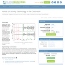
Students learn about seismology by using a sample seismograph constructed out of …
Students learn about seismology by using a sample seismograph constructed out of common classroom materials. The seismograph creates a seismogram based on vibrations caused by moving a ruler. The students work in groups to represent an engineering firm that must analyze the seismograph for how it works and how to read the seismogram it creates.
The high school earth and physical science unit moves through an exploration …
The high school earth and physical science unit moves through an exploration of tectonic plates, why and how they move, and the earthquakes that they cause. As the final project, teams learn about Early Warning Systems for earthquakes and how they have saved millions of lives in other countries. Teams take on a population in Oregon and design a ShakeAlert system to give them the seconds required to prepare for a mega earthquake.
Students learn about how engineers design and build shake tables to test …
Students learn about how engineers design and build shake tables to test the ability of buildings to withstand the various types of seismic waves generated by earthquakes. Just like engineers, students design and build shake tables to test their own model buildings made of toothpicks and mini marshmallows. Once students are satisfied with the performance of their buildings, they put them through a one-minute simulated earthquake challenge.
Students learn about tsunamis, discovering what causes them and what makes them …
Students learn about tsunamis, discovering what causes them and what makes them so dangerous. They learn that engineers design detection and warning equipment, as well as structures that that can survive the strong wave forces. In a hands-on activity, students use a table-top-sized tsunami generator to observe the formation and devastation of a tsunami. They see how a tsunami moves across the ocean and what happens when it reaches a coastline. They make villages of model houses to test how different material types are impacted by the huge waves.
There is a 40% chance that the lower ⅓ of the of …
There is a 40% chance that the lower ⅓ of the of the Cascadia subduction zone will rupture in the next 50 years, generating a large earthquake and ensuing tsunami. In this project, students will work collaboratively to design and test a model of a vertical evacuation structure. They will evaluate the performance of their models and propose further modifications to improve their design. Students will then make a scale drawing and a model to apply math concepts of scale to designing and creating an ideal model of a vertical evacuation structure. Finally, students will present their findings and proposed final design to their peers and an adult audience. The entire process takes about 2 weeks, and was expanded to include more information and activities with earthquake/tsunami prediction and application of scale. The unit is a great fit for standards within Earth Science (specifically plate tectonics and human mitigation) as well as Engineering and Design standards.
No restrictions on your remixing, redistributing, or making derivative works. Give credit to the author, as required.
Your remixing, redistributing, or making derivatives works comes with some restrictions, including how it is shared.
Your redistributing comes with some restrictions. Do not remix or make derivative works.
Most restrictive license type. Prohibits most uses, sharing, and any changes.
Copyrighted materials, available under Fair Use and the TEACH Act for US-based educators, or other custom arrangements. Go to the resource provider to see their individual restrictions.