Finding and eradicating invasive plants is a tough job that requires constant …
Finding and eradicating invasive plants is a tough job that requires constant vigilance. County-scale maps that show where invasive plants are and where they have the potential to spread in the future are helping on-the-ground efforts to build the resilience of natural vegetation.
Increasingly volatile climate and weather; vulnerable drinking water supplies; shrinking wildlife habitats; …
Increasingly volatile climate and weather; vulnerable drinking water supplies; shrinking wildlife habitats; widespread deforestation due to energy and food production. These are examples of environmental challenges that are of critical importance in our world, both in far away places and close to home, and are particularly well suited to inquiry using geographic information systems. In GEOG 487 you will explore topics like these and learn about data and spatial analysis techniques commonly employed in environmental applications. After taking this course you will be equipped with relevant analytical approaches and tools that you can readily apply to your own environmental contexts.
This module focuses on the description of different vetation types that may …
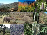
This module focuses on the description of different vetation types that may be of use as part of an introductory physical geography course (biogeography), or for a class focused on the study of plants and vegetation. All images were collected from travels to learn about vegetation over the past 40 years and I openly make them available through the OER site. The resources attached to the module include:I. Description of terms used to describe and distinguish among global vegetation types (biomes)- descriptive notes and imagesII. Tropical Vegetation Types- descriptive notes and powerpoint slide showIIIl Subtropical_Temperate_Arctic Vegetation Types- descriptive notes; powerpoint slide show; supportive lists for desert and montane species.
This course provides students with a scientific foundation of anthropogenic climate change …
This course provides students with a scientific foundation of anthropogenic climate change and an introduction to climate models. It focuses on fundamental physical processes that shape climate (e.g. solar variability, orbital mechanics, greenhouse gases, atmospheric and oceanic circulation, and volcanic and soil aerosols) and on evidence for past and present climate change. During the course they discuss material consequences of climate change, including sea level change, variations in precipitation, vegetation, storminess, and the incidence of disease. This course also examines the science behind mitigation and adaptation proposals.
This resource is a video abstract of a research paper created by …
This resource is a video abstract of a research paper created by Research Square on behalf of its authors. It provides a synopsis that's easy to understand, and can be used to introduce the topics it covers to students, researchers, and the general public. The video's transcript is also provided in full, with a portion provided below for preview:
"Forests are disappearing at an alarming rate, with human activities such as logging being a major cause of this loss. One way China is addressing this problem is through so-called mountain closure, that is, by stopping all anthropogenic activity within degraded forests. But precisely how mountain closure affects ecosystem renewal isn’t well known. To answer this question, researchers have turned their attention underground, to fine roots. By following the status of these structures, they’ve shed light on how forests renew themselves over the decades after human activity is stopped. Plants use fine roots to acquire water and nutrients from soil, which gives them a crucial role in terrestrial carbon and nutrient cycling. Because soil composition is key to ecosystem productivity, changes in fine root abundance are one indicator of a forest’s health. This prompted the researchers to use fine roots to assess how forests fare after closure..."
The rest of the transcript, along with a link to the research itself, is available on the resource itself.
No restrictions on your remixing, redistributing, or making derivative works. Give credit to the author, as required.
Your remixing, redistributing, or making derivatives works comes with some restrictions, including how it is shared.
Your redistributing comes with some restrictions. Do not remix or make derivative works.
Most restrictive license type. Prohibits most uses, sharing, and any changes.
Copyrighted materials, available under Fair Use and the TEACH Act for US-based educators, or other custom arrangements. Go to the resource provider to see their individual restrictions.