In analyzing fiscal issues, conventional public finance approaches focus mainly on taxation …
In analyzing fiscal issues, conventional public finance approaches focus mainly on taxation and public spending. Policymakers and practitioners rarely explore solutions by examining the fundamental problem: the failure of interested parties to act collectively to internalize the positive externalities generated by public goods. Public finance is merely one of many possible institutional arrangements for assigning the rights and responsibilities to public goods consumption. This system is currently under stress because of the financial crisis. The first part of the class will focus on collective action and its connection with local public finance. The second part will explore alternative institutional arrangements for mediating collective action problems associated with the provision of local public goods. The objective of the seminar is to broaden the discussion of local public finance by incorporating collective action problems into the discourse. This inclusion aims at exploring alternative institutional arrangements for financing local public services in the face of severe economic downturn. Applications of emerging ideas to the provision of public health, education, and natural resource conservation will be discussed.
This course focuses on the archaeology of the Greek and Roman city. …
This course focuses on the archaeology of the Greek and Roman city. It investigates the relationship between urban architecture and the political, social, and economic role of cities in the Greek and Roman world, by analyzing a range of archaeological and literary evidence relevant to the use of space in Greek and Roman cities (e.g. Athens, Paestum, Rome, Pompeii) and a range of theoretical frameworks for the study of ancient urbanism.
This course serves as an introduction to urban form and design, focusing …
This course serves as an introduction to urban form and design, focusing on the physical, historical, and social form of cities. Selected cities are analyzed, drawn, and compared, to develop a working understanding of urban and architectural form. The development of map making and urban representation is discussed, and use of the computer is required. A special focus is placed on the historical development of the selected cities, especially mid-nineteenth and mid-twentieth century periods of expansion. Readings focus on urban design theory in the twentieth century and will be discussed during a weekly seminar on them. This is a methods class for S.M.Arch.S. students in Architecture and Urbanism.
Using film as a lens to explore and interpret various aspects of …
Using film as a lens to explore and interpret various aspects of the urban experience in both the U.S. and abroad, this course presents a survey of important developments in urbanism from 1900 to the present day, including changes in technology, bureaucracy, and industrialization; immigration and national identity; race, class, gender, and economic inequality; politics, conformity, and urban anomie; and planning, development, private property, displacement, sprawl, environmental degradation, and suburbanization.
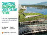
The class of CIVE230: Engineering and Sustainable Development have been at it …
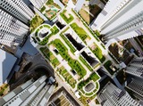
The class of CIVE230: Engineering and Sustainable Development have been at it again, learning remotely in Spring 2021. This is the second COVID-19 edition of the course!The course introduces sustainability on two levels: qualitative concepts and background information is covered; and quantitative models which emphasize core engineering methods are applied to sustainability problems. Quantitative methods are derived and applied to air quality, water quality, energy and solid waste. Attention is given to sustainable urban systems, as they apply to both developed and developing countries. Sustainability concepts covering the triple bottom line are also presented, and their applicability to sustainable cities are demonstrated. Students in the course were tasked with making a contribution to an e-book. They were creative and innovative in applying course concepts to cities of their choice and exploring sustainability challenges and innovations. Their sustainability project encouraged them to explore sustainable infrastructure, solutions and technologies in Canada and globally to generate an enriched learning experience and to tie ideas to the Sustainable Development Goals (SDG) and the Canadian Engineering Grand Challenges (CEGC).
Learning about sustainability requires systems-thinking and a curiosity to explore. When learning …
Learning about sustainability requires systems-thinking and a curiosity to explore. When learning opportunities are created for students so that go beyond the course content by learning from the world around us and from each other, they get so much more out of the course. This e-book has been the project experience that allowed students to explore topics of their choice in cities of their choice!This e-book serves as a contribution by the class for the class, and for the wider UW and engineering community. Have a read through.
After decades of efforts to promote development, why is there so much …
After decades of efforts to promote development, why is there so much poverty in the world? What are some of the root causes of inequality world-wide and why do poverty, economic transformations and development policies often have different consequences for women and men? This course explores these issues while also examining the history of development itself, its underlying assumptions, and its range of supporters and critics. It considers the various meanings given to development by women and men, primarily as residents of particular regions, but also as aid workers, policy makers and government officials. In considering how development projects and policies are experienced in daily life in urban and rural areas in Africa, Latin America, Asia and Melanesia, this course asks what are the underlying political, economic, social, and gender dynamics that make "development" an ongoing problem world-wide.
This class explores the political and aesthetic foundations of hip hop. Students …
This class explores the political and aesthetic foundations of hip hop. Students trace the musical, corporeal, visual, spoken word, and literary manifestations of hip hop over its 30 year presence in the American cultural imagery. Students also investigate specific black cultural practices that have given rise to its various idioms. Students create material culture related to each thematic section of the course. Scheduled work in performance studio helps students understand how hip hop is created and assessed.
A truly inter-disciplinary course, Housing and Land Use in Rapidly Urbanizing Regions …
A truly inter-disciplinary course, Housing and Land Use in Rapidly Urbanizing Regions reviews how law, economics, sociology, political science, and planning conceptualize urban land and property rights and uses cases to discuss what these different lenses illuminate and obscure. It also looks at how the social sciences might be informed by how design, cartography, and visual studies conceptualize space's physicality. This year's topics include land trusts for affordable housing, mixed-use in public space, and critical cartography.
Our planet is currently being challenged by dramatic changes to earth and …
Our planet is currently being challenged by dramatic changes to earth and human systems under the influence of climate change and variability. These include changes of population and environmental dynamics that impacts human health. Thus, climate change is considered the biggest threat to human health in the 21st century. Health impacts can be direct typically related to extreme weather events; indirect with linkages to climate change induced environmental alterations and damage or in relation to displacement, conflict and social disruption. This presentation provides a series of examples of changes of environmental and social determinants of health with negative or positive health impacts. These include impacts on communicable diseases, non-communicable diseases and mental health of importance in particular in vulnerable urban and rural settings as well as among sensitive community groups exposed to variations in temperature and precipitation patterns.
This introductory survey course is intended to develop an understanding of key …
This introductory survey course is intended to develop an understanding of key issues and dilemmas of planning in non-Western countries. The issues covered by the course include state intervention, governance, law and institutions in development, privatization, participatory planning, decentralization, poverty, urban-rural linkages, corruption and civil service reform, trade and outsourcing and labor standards, post-conflict development and the role of aid in development.
The primary purpose of this seminar is to enable students to craft …
The primary purpose of this seminar is to enable students to craft approaches to so-called "First World"/ "Third World" city comparisons that are theoretically sophisticated, methodologically rigorous, contextually grounded, and significantly beneficial. Since there exists very little literature and very few projects which compare "First World" and "Third World" cities in a sophisticated and genuinely useful manner, the seminar is structured around a series of readings, case studies, and discussions to assist students in becoming mindful of the potential and pitfalls of comparative analysis, the types of data, the methods of analysis, and the urban issues or sectors which may benefit the most from such approaches. The course is designed to be interdisciplinary and interactive, and is geared towards masters and doctoral students.
Alienation, overcrowding, sensory overload, homelessness, criminality, violence, loneliness, sprawl, blight. How have …
Alienation, overcrowding, sensory overload, homelessness, criminality, violence, loneliness, sprawl, blight. How have the realities of city living influenced literature's formal and thematic techniques? How useful is it to think of literature as its own kind of "map" of urban space? Are cities too grand, heterogeneous, and shifting to be captured by writers? In this seminar we will seek answers to these questions in key city literature, and in theoretical works that endeavor to understand the culture of cities.
This workshop explores the potential of media technology and the Internet to …
This workshop explores the potential of media technology and the Internet to enhance communication and transform city design and community development in inner-city neighborhoods. The class introduces a variety of methods for describing or representing a place and its residents, for simulating actions and changes, for presenting visions of the future, and for engaging multiple actors in the process of envisioning change and guiding action. Students will engage one neighborhood, meet real people working on real projects, put theory into practice, and reflect on insights gained in the process. This year the course will examine what it means to be an urban designer/planner and how to create a digital teaching tool (using digital storytelling) that supports others in learning about the relationship between design and planning professionals, on the one hand, and members of the communities they serve, on the other. What is the nature of the knowledge that resides in a community and how can designers and planners learn about, tap, and use that knowledge? What is the relationship between community organizing and urban design and planning? What are the relationships between you as a professional, the place(s) in which you work, and the values and care you bring to that work? We will explore these themes in the context of Camfield Estates in Lower Roxbury, MA and its participation in the US Department of Housing and Urban Development's (HUD) Demonstration Disposition Project. There have been many stories written about Camfield Estates' participation in the Demonstration Disposition project, for it has been widely regarded as a model of success. There are two stories that have not yet been told, however: the story of the residents who organized the community and the story of the architects and planners who participated in the project. This course will use digital storytelling to reconstruct and connect these two stories.
This course provides an introduction to public policy analysis. It is designed …
This course provides an introduction to public policy analysis. It is designed for students who may be planning a career in public or non-profit sectors. The primary goal is to help students understand the implications of public policy for different pursuits. The class examines various approaches to policy analysis by considering the concepts, tools, and methods used in economics, political science, and other disciplines. Students apply and critique these approaches through case studies of current public policy problems.
The goal of this course is to offer a general introduction to …
The goal of this course is to offer a general introduction to 20th and 21st century literature and cultural production about Modern Mexico. Emphasis will be placed on the way intellectuals and artists have presented the changes in Mexico City's urban life, and how these representations question themes and trends in national identity, state control, globalization, and immigration.
Trees grow all around us. Sometimes they are in large forests and …
Trees grow all around us. Sometimes they are in large forests and sometimes they are single trees along the road or in our schoolyards. In this storyline, students explore cultural connections with trees, learn about the characteristics of trees, and discover what trees need to grow through handson activities, art, and literacy integration.
Students will learn how trees grow and cycle matter, and trees’ roles …
Students will learn how trees grow and cycle matter, and trees’ roles in a changing climate. The urban heat island effect is examined and students learn about the many benefits trees offer cities. The storyline culminates with students examining the trees and canopy cover in their or a nearby city and proposing actions to increase the urban forest through a letter to city officials.
This is a solutions-oriented storyline that leads students through a series of …
This is a solutions-oriented storyline that leads students through a series of investigations to quantify and qualify the ecosystem and social benefits of an urban forest. At the end of the storyline, students will be able to design, evaluate and refine a chosen solution for urban forest ecosystem benefits.
Urban forests provide many benefits to a community and can minimize the …
Urban forests provide many benefits to a community and can minimize the human impact on the environment. Students will explore the impacts an urban community has on the environment. Students will discover the role trees play in an urban community and how trees can affect the ecosystem, human wellbeing, and provide economic value. Students will explore Indigenous relationships with trees. During the course of this storyline, students will measure and monitor urban forest ecosystem benefits, perform a field investigation, and design a development to minimize negative environmental impacts
No restrictions on your remixing, redistributing, or making derivative works. Give credit to the author, as required.
Your remixing, redistributing, or making derivatives works comes with some restrictions, including how it is shared.
Your redistributing comes with some restrictions. Do not remix or make derivative works.
Most restrictive license type. Prohibits most uses, sharing, and any changes.
Copyrighted materials, available under Fair Use and the TEACH Act for US-based educators, or other custom arrangements. Go to the resource provider to see their individual restrictions.