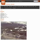
This page from the Volcano World website contains a summary account of …
This page from the Volcano World website contains a summary account of the 1959 eruption at Kilauea Iki which is illustrated by photographs and videos.
The course treats the following topics: - Relevant physical oceanography - Elements …
The course treats the following topics: - Relevant physical oceanography - Elements of marine geology (seafloor topography, acoustical properties of sediments and rocks) - Underwater sound propagation (ray acoustics, ocean noise) - Interaction of sound with the seafloor (reflection, scattering) - Principles of sonar (beamforming) - Underwater acoustic mapping systems (single beam echo sounding, multi-beam echo sounding, sidescan sonar) - Data analysis (refraction corrections, digital terrain modelling) - Applications (hydrographic survey planning and navigation, coastal engineering) - Current and future developments.
Long Description: Located at https://courses.lumenlearning.com/labmethods/ Word Count: 9849 (Note: This resource's metadata …
Long Description: Located at https://courses.lumenlearning.com/labmethods/
Word Count: 9849
(Note: This resource's metadata has been created automatically by reformatting and/or combining the information that the author initially provided as part of a bulk import process.)
Long Description: Located at https://courses.lumenlearning.com/labmethods/ Word Count: 13827 (Note: This resource's metadata …
Long Description: Located at https://courses.lumenlearning.com/labmethods/
Word Count: 13827
(Note: This resource's metadata has been created automatically by reformatting and/or combining the information that the author initially provided as part of a bulk import process.)
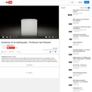
This short film uses graphics to provide an introduction to the physical …
This short film uses graphics to provide an introduction to the physical causes of earthquakes, and to explore how the way we build and manage our cities determines their vulnerability to a seismic strike.
It was created with the UK GCSE and A' Level curricula in mind.
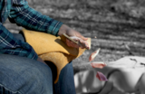
Explore the physics and material science of making stone tools. Educator Nate …
Explore the physics and material science of making stone tools. Educator Nate Salzman walks us through the surprisingly complex science of flintknapping, or the process of turning stone into blades, arrowheads, spear points, axes, jewelry and more. Making tools from stone may be thousands of years old, but required people to think about the properties of the material they were using and the physics of striking the stone to shape it just right.NOTE: These are animations derived from the video "The Science of Knapping" which is linked here and published under its own listing on OER Commons.This resource is part of Jefferson Patterson Park and Museum’s open educational resources project to provide history, ecology, archaeology, and conservation resources related to our 560 acre public park. More of our content can be found on YouTube and SketchFab. JPPM is a part of the Maryland Historical Trust under the Maryland Department of Planning.
This presentation offers an overview of the developing concept of The Anthropocene …
This presentation offers an overview of the developing concept of The Anthropocene -- a term coined to describe our current geological epoch, in which human impact on the planet will leave a permanent trace.
In this problem-based learning module, students will ‘dig’ for fossils in a digital …
In this problem-based learning module, students will ‘dig’ for fossils in a digital environment, using the advanced graphing techniques of line-of-best-fit and piecewise functions to look for different kinds of trends in the health of the history of the earth. They will apply this information to their knowledge of the laws of superposition and index fossils to form a complete analysis in the historical health as well as to predict where we are going in the future.
This video segment describes how the Australopithecus afarensis skeleton known as Lucy …
This video segment describes how the Australopithecus afarensis skeleton known as Lucy could have been fossilized. Footage courtesy of NOVA: "In Search of Human Origins."
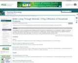
X-ray diffraction is a quick and valuable tool for identifying minerals. Minerals …
X-ray diffraction is a quick and valuable tool for identifying minerals. Minerals are an integral portion of our everyday life, in addition to composing our planet! They help bring electricity into our homes and remove our bathtub rings. In this lab, students analyze the X-ray diffraction patterns of three household cleansers, Ajax, White Magic, and Soft Scrub, in order to identify the abrasive minerals in each.
(Note: this resource was added to OER Commons as part of a batch upload of over 2,200 records. If you notice an issue with the quality of the metadata, please let us know by using the 'report' button and we will flag it for consideration.)
There are many, including my environmental and civil engineering technology students, who …
There are many, including my environmental and civil engineering technology students, who do not have decades to commit to developing a working understanding of the Earth and the specific geological and geomorphological contexts they may find themselves working in. Therefore, this textbook is designed to provide a brief introduction to the concepts of geology and geomorphology, with an Ontarian perspective. It serves as a good starting point for individuals who have neither prior experience nor knowledge in geology nor geomorphology. In order to adequately explain concepts that unfold in four dimensions (3 dimensions with time as the fourth), an electronic format is used to leverage enhanced illustrations. These illustrations include traditional 2D figures; however, videos, animations, and interactive figures are also used to help create a deeper understanding.
BRIGHT Girls was a project to build broader participation in the sciences, …
BRIGHT Girls was a project to build broader participation in the sciences, led by the University of Alaska Fairbanks and funded by the National Science Foundation. We sought to increase students' motivation and capacity to pursue careers in STEM by engaging them in studies of nearby natural environments. The developed lesson plans may be used in formal or informal educational settings, e.g., in a summer academy or across multiple class periods. These investigations help students explore the relationships among life history and ecosystems, connecting biology to geology and remote sensing.
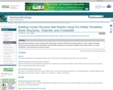
This activity involves building crystal structure ball models in order to strengthen …
This activity involves building crystal structure ball models in order to strengthen students' understanding of crystalline order, relative atomic size, atomic coordination, crystal chemistry, and crystal symmetry.
(Note: this resource was added to OER Commons as part of a batch upload of over 2,200 records. If you notice an issue with the quality of the metadata, please let us know by using the 'report' button and we will flag it for consideration.)
In this lab exercise, students examine one or more metamorphic rocks and …
In this lab exercise, students examine one or more metamorphic rocks and use various approaches to estimating and calculating the pressure-temperature conditions at which the rocks equilibrated. The exercise involves hand sample description, petrography, interpretation of phase diagrams, and calculations of a phase diagram or P-T conditions from given equations.
This learning video uses a simple analog setup to explore why earthquakes …
This learning video uses a simple analog setup to explore why earthquakes are so unpredictable. The setup is simple enough that students should be able to assemble and operate it on their own with a teacher's supervision. The teaching approach used in this module is known as the 5E approach, which stands for Engagement, Exploration, Explanation, Elaboration, and Evaluation. Over the course of this lesson, the basic mechanisms that give rise to the behavior of the simple analog system are explained, and further elaboration helps the students to apply their understanding of the analog system to complex fault systems that cause earthquakes
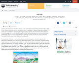
This module provides an overview of the biogeochemical carbon cycle. Major sources …
This module provides an overview of the biogeochemical carbon cycle. Major sources and sinks of carbon are discussed as well as the impact of human activities on global carbon levels.
Students consider the Earth's major types of landforms such as mountains, rivers, …
Students consider the Earth's major types of landforms such as mountains, rivers, plains, hills, canyons, oceans and plateaus. Student teams build three-dimensional models of landscapes, depicting several of these landforms. Once the models are built, they act as civil and transportation engineers to design and build roads through the landscapes they have created. The worksheet is provided in English and Spanish.
This interactive resource adapted from the National Park Service presents the key …
This interactive resource adapted from the National Park Service presents the key concepts of cave and karst systems, including how and where they form, different types, and various cave environments.
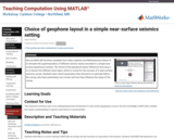
Click to watch Alain Plattner discuss his activity or watch the full webinar.We use MATLAB functions available from https://github.com/NSGeophysics/Seism-O to simulate the superimposition of different seismic waves recorded in a simple near-surface geophysics setting. The choice of the geophone layout influences how easy it is to discern the different wave types, which is crucial for the success of a near-surface seismics survey. Students learn which parameters they should try to estimate before the survey, why these parameters are crucial, and how they influence the setup of the survey.
(Note: this resource was added to OER Commons as part of a batch upload of over 2,200 records. If you notice an issue with the quality of the metadata, please let us know by using the 'report' button and we will flag it for consideration.)
No restrictions on your remixing, redistributing, or making derivative works. Give credit to the author, as required.
Your remixing, redistributing, or making derivatives works comes with some restrictions, including how it is shared.
Your redistributing comes with some restrictions. Do not remix or make derivative works.
Most restrictive license type. Prohibits most uses, sharing, and any changes.
Copyrighted materials, available under Fair Use and the TEACH Act for US-based educators, or other custom arrangements. Go to the resource provider to see their individual restrictions.