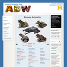
This site is a searchable encyclopedia of thousands of photos, descriptions, sound …
This site is a searchable encyclopedia of thousands of photos, descriptions, sound recordings, and other information about individual animal species. Find out about amphibians, arthropods, birds, fishes, insects, mammals, mollusks, reptiles, and sharks. Explore special features on mammals, skulls, and frog calls. Students are invited to contribute.
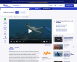
In this video segment, ZOOM guest Cassie takes us on a tour …
In this video segment, ZOOM guest Cassie takes us on a tour of the coral reef near her home in Key Largo, Florida, and points out some of its unique features.
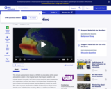
This video segment adapted from NASA's Goddard Space Flight Center describes El …
This video segment adapted from NASA's Goddard Space Flight Center describes El Niño, how it forms, and the chain reaction of consequences it triggers around the globe.
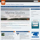
Located in Newport, Oregon, Hatfield Marine Science Center plays an integral role …
Located in Newport, Oregon, Hatfield Marine Science Center plays an integral role in programs of marine and estuarine research and instruction, as a laboratory facility serving resident scientists, as a base for far-ranging oceanographic studies, and as a classroom for students. Site features information on courses, seminars, facilities, and current research. Education Programs section includes teacher and student resources. Resources applicable to local and distant educators.
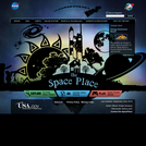
This site provides fun activities for children to do and make, while …
This site provides fun activities for children to do and make, while they learn about space and Earth science, and the technology that enables science. The Teachers Corner on the WWW site contains curriculum supplements originally published in the ITEA (International Technology Education Association) Technology Transfer Teacher magazine.
No restrictions on your remixing, redistributing, or making derivative works. Give credit to the author, as required.
Your remixing, redistributing, or making derivatives works comes with some restrictions, including how it is shared.
Your redistributing comes with some restrictions. Do not remix or make derivative works.
Most restrictive license type. Prohibits most uses, sharing, and any changes.
Copyrighted materials, available under Fair Use and the TEACH Act for US-based educators, or other custom arrangements. Go to the resource provider to see their individual restrictions.