Air pressure is pushing on us all the time although we do …
Air pressure is pushing on us all the time although we do not usually notice it. In this activity, students learn about the units of pressure and get a sense of just how much air pressure is pushing on them.
An interactive applet and associated web page that explain the area of …
An interactive applet and associated web page that explain the area of a triangle. The applet shows a triangle that can be reshaped by dragging any vertex. As it changes, the area is continually recalculated using the 'half base times height' method. The triangle has a fixed square grid in its interior that can be used to visually estimate the area for later correlation with the calculated value. The calculation can be hidden while estimation is in progress. The text page has links to a similar page that uses Heron's Formula to compute the area. Applet can be enlarged to full screen size for use with a classroom projector. This resource is a component of the Math Open Reference Interactive Geometry textbook project at http://www.mathopenref.com.
Students learn the importance of the Pythagorean theorem as applied in radar …
Students learn the importance of the Pythagorean theorem as applied in radar imaging. They use a sensor unit with IRED (infrared emitting diode) to measure triangle distances and the theorem to calculate and verify distances. Student groups calibrate the sensor units to ensure accurate distance measurements. A "pretend" outdoor radar imaging model is provided to groups for sensor unit testing.
In this lesson, students will investigate error. As shown in earlier activities …
In this lesson, students will investigate error. As shown in earlier activities from navigation lessons 1 through 3, without an understanding of how errors can affect your position, you cannot navigate well. Introducing accuracy and precision will develop these concepts further. Also, students will learn how computers can help in navigation. Often, the calculations needed to navigate accurately are time consuming and complex. By using the power of computers to do calculations and repetitive tasks, one can quickly see how changing parameters likes angles and distances and introducing errors will affect their overall result.
The Hot Balloon game lets you control the altitude of the balloon …
The Hot Balloon game lets you control the altitude of the balloon through heating the balloon or releasing air from the air flaps. Hot air rises the balloon through a force called buoyancy. The difference between the outside and the inside air determines the amount of buoyancy. Using weight difference, wind speeds and limited fuel the balloon can go on the farthest rides.
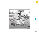
In this lesson, students will learn how great navigators of the past …
In this lesson, students will learn how great navigators of the past stayed on course that is, the historical methods of navigation. The concepts of dead reckoning and celestial navigation are discussed.
Students develop an understanding of air pressure by using candy or cookie …
Students develop an understanding of air pressure by using candy or cookie wafers to model how it changes with altitude, by comparing its magnitude to gravitational force per unit area, and by observing its magnitude with an aluminum can crushing experiment.
In this lesson, students will compare weather and climate, explain patterns over …
In this lesson, students will compare weather and climate, explain patterns over time and participate in a climate relay race.
NGSS: K-ESS2-1
Time: 45-50 minutes
Materials: globe, flashlight, three sets of clothing for the relay race (sunglasses, sunhat, swim suit, board shorts, rain jacket, hiking boots, umbrella, sweater, heavy jacket, warm hat, gloves, scarf, etc.)
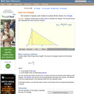
An interactive applet and associated web page that introduce the concept of …
An interactive applet and associated web page that introduce the concept of a triangle. The applet shows a triangle where the user can drag the vertices to reshape it. As it is being dragged a base and altitude are shown continuously changing. Demonstrates that the altitude may require the base to be extended. The text on the page lists the properties of a triangle and lists the various triangle types, with links to a definition of each. Applet can be enlarged to full screen size for use with a classroom projector. This resource is a component of the Math Open Reference Interactive Geometry textbook project at http://www.mathopenref.com.
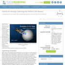
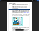
This is a lesson about the vertical dimension of the atmosphere and …
This is a lesson about the vertical dimension of the atmosphere and includes four activities. Activity 1 Introduces concepts related to distance, including length and height and units of measurement. Students are asked to make comparisons of distances. In activity 2, students learn about the vertical profile of the atmosphere. They work with a graph and plot the heights of objects and the layers of the atmosphere: troposphere, stratosphere, mesosphere, thermosphere, and exosphere. In activity 3, students learn about other forms of visual displays using satellite imagery. They compare images of the same weather feature, a hurricane, using two different images from MODIS and CALIPSO. One image is looking down on the hurricane from space, the other looks through the hurricane to display a profile of the hurricane. Activity 4 reinforces the concept of the vertical nature of the atmosphere. Students will take a CALIPSO satellite image that shows a profile of the atmosphere and use this information to plot mountains and clouds on their own graph of the atmosphere. The recommended order for the activities is to complete the first two activities on day one, and the second two activities on day two. Each day will require approximately 1 to 1.5 hours.
Students are introduced to some essential meteorology concepts so they more fully …
Students are introduced to some essential meteorology concepts so they more fully understand the impact of meteorological activity on air pollution control and prevention. First, they develop an understanding of the magnitude and importance of air pressure. Next, they build a simple aneroid barometer to understand how air pressure information is related to weather prediction. Then, students explore the concept of relative humidity and its connection to weather prediction. Finally, students learn about air convection currents and temperature inversions. In an associated literacy activity, students learn how scientific terms are formed using Latin and Greek roots, prefixes and suffixes, and are introduced to the role played by metaphor in language development. Note: Some of these activities can be conducted simultaneously with the air quality activity (What Color Is Your Air Today?) of Air Pollution unit, Lesson 1.
How does our climate affect us? How do we decide what to …
How does our climate affect us? How do we decide what to wear each day? What factors determine if our clothing choices are comfortable? What is the source of our water? Students explore characteristics that define climatic regions. They learn how tropical, desert, coastal and alpine climates result in different lifestyle, clothing, water source and food options for the people who live there. They learn that a location's latitude, altitude, land features, weather conditions, and distance from large bodies of water, determines its climate. Students discuss how engineers help us adapt to all climates by designing clothing, shelters, weather technologies and clean water systems.
How do we know where we are? What happens if you are …
How do we know where we are? What happens if you are completely lost in the middle of nowhere? Does technology provide tools for people lost in their travels? A person cannot usually determine an accurate position just by looking out a window in the middle of the ocean or vast area of land, particularly if it has not been charted before. In this lesson, students explore the concept of triangulation that is used in navigation satellites and global positioning systems designed by engineers. Also, students learn how these technologies can help people determine their position or the location of someone else.
No restrictions on your remixing, redistributing, or making derivative works. Give credit to the author, as required.
Your remixing, redistributing, or making derivatives works comes with some restrictions, including how it is shared.
Your redistributing comes with some restrictions. Do not remix or make derivative works.
Most restrictive license type. Prohibits most uses, sharing, and any changes.
Copyrighted materials, available under Fair Use and the TEACH Act for US-based educators, or other custom arrangements. Go to the resource provider to see their individual restrictions.